Morris County Rolled Sketch 2A
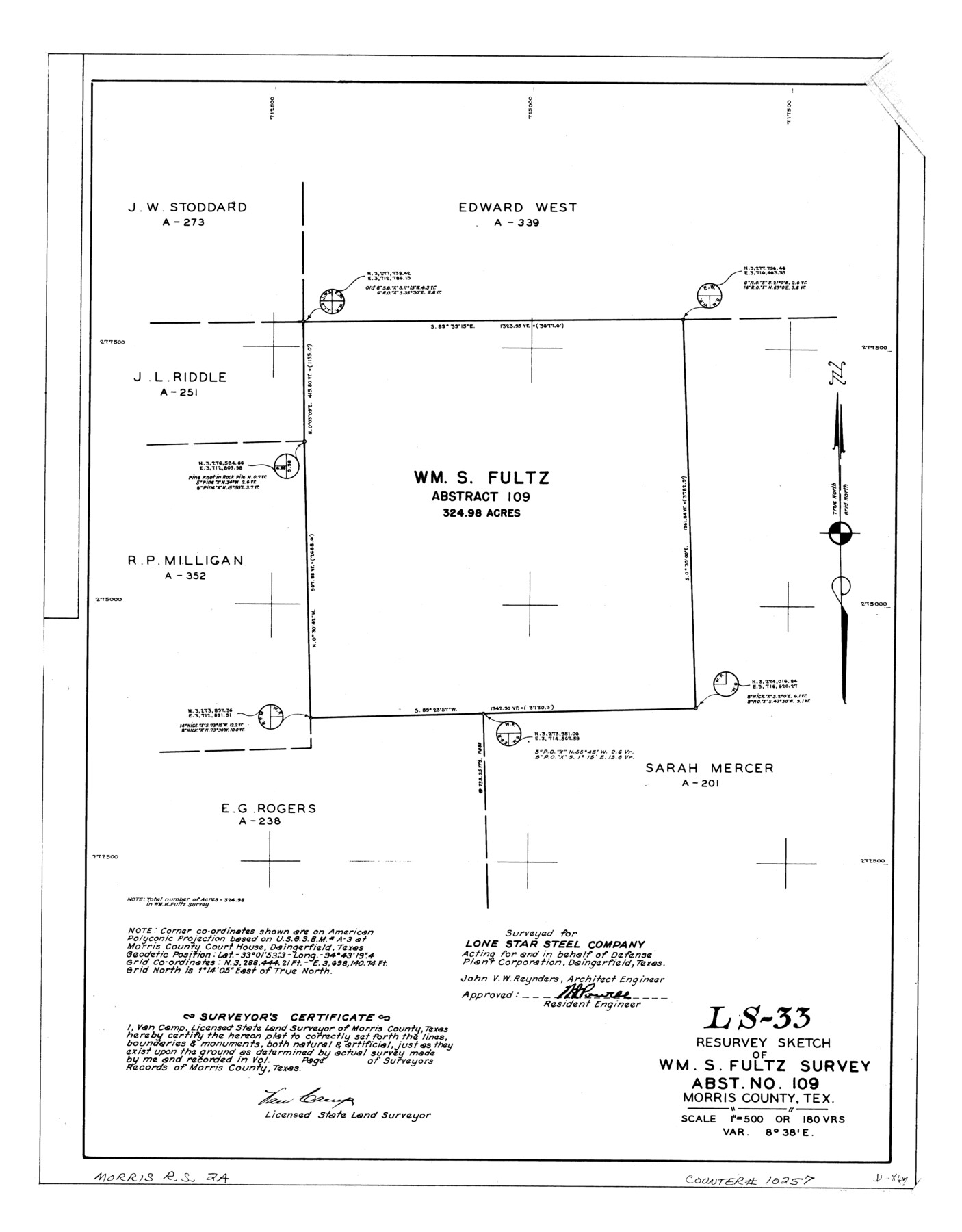
LS-33 - Resurvey sketch of Wm. S. Fultz survey, abst. no. 109, Morris County, Tex.
-
Map/Doc
10257
-
Collection
General Map Collection
-
People and Organizations
Van Camp (Surveyor/Engineer)
-
Counties
Morris
-
Subjects
Surveying Rolled Sketch
-
Height x Width
24.0 x 18.8 inches
61.0 x 47.8 cm
-
Medium
linen, manuscript
-
Scale
1" = 180 varas
-
Comments
See Morris County Rolled Sketch 2 (9550) for map of all retracement surveys made for Lone Star Steel Company.
Related maps
Morris County Rolled Sketch 2

Print $40.00
- Digital $50.00
Morris County Rolled Sketch 2
1944
Size 59.4 x 43.5 inches
Map/Doc 9550
Part of: General Map Collection
Jasper County Sketch File 5

Print $4.00
- Digital $50.00
Jasper County Sketch File 5
Size 8.4 x 12.1 inches
Map/Doc 27770
[F. W. & D. C. Ry. Co. Alignment and Right of Way Map, Clay County]
![64722, [F. W. & D. C. Ry. Co. Alignment and Right of Way Map, Clay County], General Map Collection](https://historictexasmaps.com/wmedia_w700/maps/64722-1.tif.jpg)
Print $20.00
- Digital $50.00
[F. W. & D. C. Ry. Co. Alignment and Right of Way Map, Clay County]
1927
Size 18.7 x 11.7 inches
Map/Doc 64722
Dimmit County Sketch File 46

Print $32.00
- Digital $50.00
Dimmit County Sketch File 46
1905
Size 3.9 x 9.0 inches
Map/Doc 21172
Terry County Boundary File 2a

Print $32.00
- Digital $50.00
Terry County Boundary File 2a
Size 11.6 x 8.9 inches
Map/Doc 59209

King County Working Sketch 4

Print $20.00
- Digital $50.00
King County Working Sketch 4
1939
Size 42.9 x 25.7 inches
Map/Doc 70168
Flight Mission No. DAH-17M, Frame 22, Orange County

Print $20.00
- Digital $50.00
Flight Mission No. DAH-17M, Frame 22, Orange County
1953
Size 18.8 x 22.6 inches
Map/Doc 86885
Concho County Boundary File 4

Print $2.00
- Digital $50.00
Concho County Boundary File 4
Size 12.7 x 8.4 inches
Map/Doc 51825

Panola County Working Sketch 18

Print $20.00
- Digital $50.00
Panola County Working Sketch 18
1945
Map/Doc 71427
Travis County Rolled Sketch 26

Print $20.00
- Digital $50.00
Travis County Rolled Sketch 26
1945
Size 24.6 x 25.2 inches
Map/Doc 8028
Haskell County Working Sketch 12

Print $20.00
- Digital $50.00
Haskell County Working Sketch 12
1979
Size 39.3 x 44.2 inches
Map/Doc 66070
You may also like
Cottle County Working Sketch 1

Print $20.00
- Digital $50.00
Cottle County Working Sketch 1
1895
Size 27.0 x 21.7 inches
Map/Doc 68311
Flight Mission No. CRC-2R, Frame 199, Chambers County

Print $20.00
- Digital $50.00
Flight Mission No. CRC-2R, Frame 199, Chambers County
1956
Size 18.6 x 22.4 inches
Map/Doc 84777
Right of Way and Track Map Texas & New Orleans R.R. Co. operated by the T. & N. O. R.R. Co. Dallas-Sabine Branch

Print $40.00
- Digital $50.00
Right of Way and Track Map Texas & New Orleans R.R. Co. operated by the T. & N. O. R.R. Co. Dallas-Sabine Branch
1918
Size 24.3 x 55.9 inches
Map/Doc 64156
Mason County Working Sketch 13

Print $20.00
- Digital $50.00
Mason County Working Sketch 13
1954
Size 20.0 x 29.9 inches
Map/Doc 70849
Jack County Working Sketch 21

Print $20.00
- Digital $50.00
Jack County Working Sketch 21
1993
Size 28.3 x 40.0 inches
Map/Doc 66447
Sabine County Sketch File 9

Print $6.00
Sabine County Sketch File 9
1912
Size 12.7 x 8.0 inches
Map/Doc 35624
Pendleton-Baxter Addition to Shamrock, Texas

Print $20.00
- Digital $50.00
Pendleton-Baxter Addition to Shamrock, Texas
Size 13.0 x 14.0 inches
Map/Doc 92116
Andrews County Rolled Sketch 45

Print $40.00
- Digital $50.00
Andrews County Rolled Sketch 45
1946
Size 111.7 x 41.0 inches
Map/Doc 8402
Laredo Route. Mexican National Railroad - the Shortest Line to Mexico

Print $20.00
- Digital $50.00
Laredo Route. Mexican National Railroad - the Shortest Line to Mexico
1905
Size 11.0 x 8.5 inches
Map/Doc 96589
Kerr County Rolled Sketch 21

Print $20.00
- Digital $50.00
Kerr County Rolled Sketch 21
1959
Size 44.5 x 30.5 inches
Map/Doc 9348
Dallam County

Print $20.00
- Digital $50.00
Dallam County
1901
Size 43.8 x 29.3 inches
Map/Doc 93458
Brewster County Working Sketch 3

Print $20.00
- Digital $50.00
Brewster County Working Sketch 3
1908
Size 26.4 x 19.4 inches
Map/Doc 67536