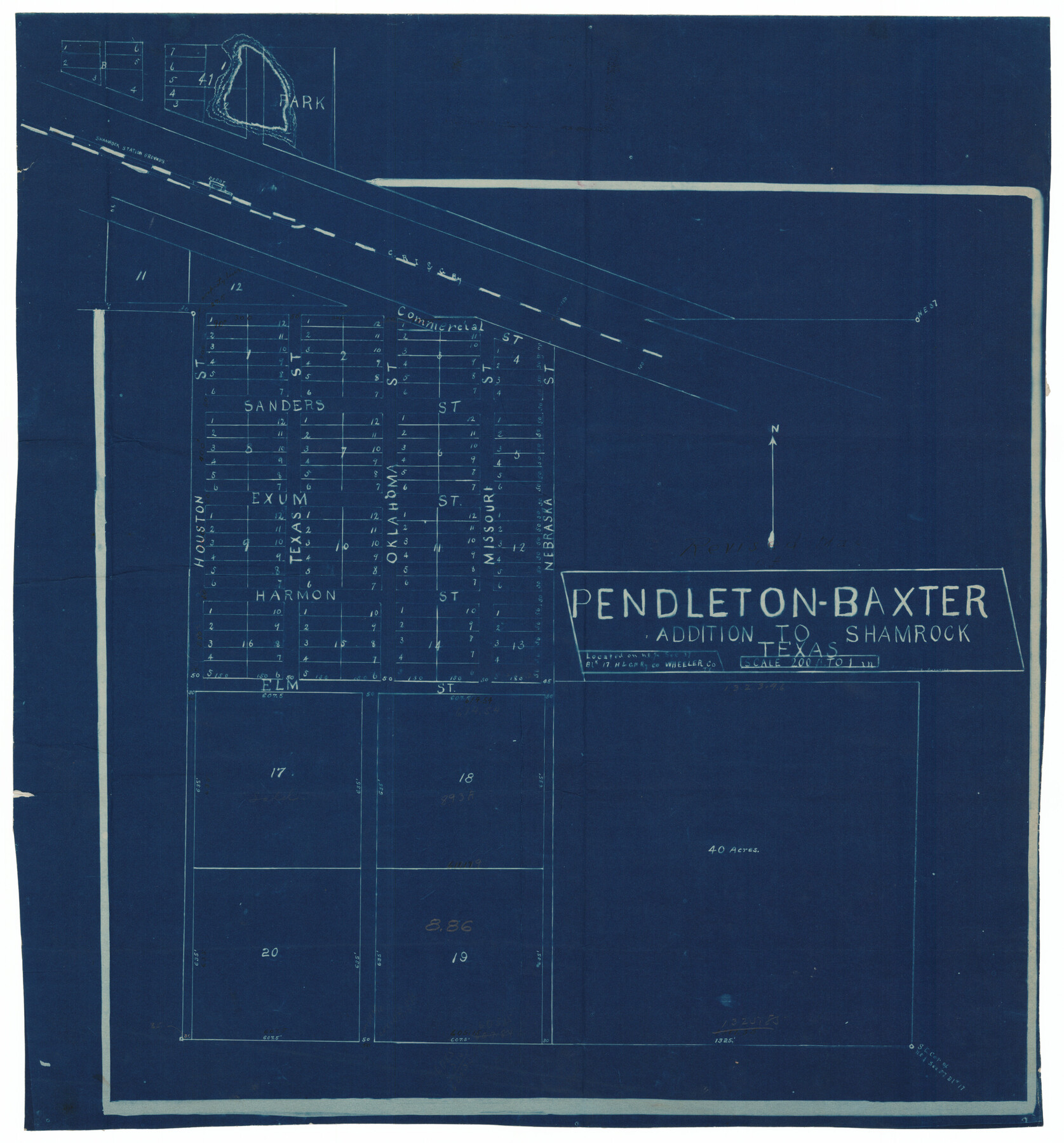
Pendleton-Baxter Addition to Shamrock, Texas
-
Map/Doc
92116
-
Collection
Twichell Survey Records
-
Counties
Wheeler
-
Height x Width
13.0 x 14.0 inches
33.0 x 35.6 cm
Part of: Twichell Survey Records
[Southern Part of County]
![91905, [Southern Part of County], Twichell Survey Records](https://historictexasmaps.com/wmedia_w700/maps/91905-1.tif.jpg)
Print $2.00
- Digital $50.00
[Southern Part of County]
Size 9.8 x 7.6 inches
Map/Doc 91905
Yellowhouse Addition to Littlefield, Texas Located on Labors 12 & 13 Capitol League 664

Print $20.00
- Digital $50.00
Yellowhouse Addition to Littlefield, Texas Located on Labors 12 & 13 Capitol League 664
1925
Size 26.9 x 26.7 inches
Map/Doc 92402
[Sketch of part of G. & M. Block 5, G. & M. Block 4, Block M19 and Block 21W]
![93092, [Sketch of part of G. & M. Block 5, G. & M. Block 4, Block M19 and Block 21W], Twichell Survey Records](https://historictexasmaps.com/wmedia_w700/maps/93092-1.tif.jpg)
Print $20.00
- Digital $50.00
[Sketch of part of G. & M. Block 5, G. & M. Block 4, Block M19 and Block 21W]
Size 22.6 x 17.7 inches
Map/Doc 93092
[Sketch showing Blocks B5 and B6 and Capitol Land Reservation]
![89973, [Sketch showing Blocks B5 and B6 and Capitol Land Reservation], Twichell Survey Records](https://historictexasmaps.com/wmedia_w700/maps/89973-1.tif.jpg)
Print $20.00
- Digital $50.00
[Sketch showing Blocks B5 and B6 and Capitol Land Reservation]
Size 46.3 x 41.9 inches
Map/Doc 89973
Levelland Independent School District Hockley County, Texas

Print $20.00
- Digital $50.00
Levelland Independent School District Hockley County, Texas
Size 36.2 x 29.8 inches
Map/Doc 92240
[Sketch showing Block M-20, Sections 9 through 46 and Block 22, Sections 1 through 12]
![91717, [Sketch showing Block M-20, Sections 9 through 46 and Block 22, Sections 1 through 12], Twichell Survey Records](https://historictexasmaps.com/wmedia_w700/maps/91717-1.tif.jpg)
Print $3.00
- Digital $50.00
[Sketch showing Block M-20, Sections 9 through 46 and Block 22, Sections 1 through 12]
Size 10.9 x 13.9 inches
Map/Doc 91717
Blocks T1, T2, T3, S3, A, O5, and Capitol Leagues]
![91074, Blocks T1, T2, T3, S3, A, O5, and Capitol Leagues], Twichell Survey Records](https://historictexasmaps.com/wmedia_w700/maps/91074-1.tif.jpg)
Print $20.00
- Digital $50.00
Blocks T1, T2, T3, S3, A, O5, and Capitol Leagues]
Size 30.0 x 33.4 inches
Map/Doc 91074
Bravo Deed, Instrument 24, Tract A and Tract B

Digital $50.00
Bravo Deed, Instrument 24, Tract A and Tract B
Map/Doc 91480
Part of Block T-2 Lamb County Texas

Print $20.00
- Digital $50.00
Part of Block T-2 Lamb County Texas
1952
Size 14.3 x 24.6 inches
Map/Doc 92182
Famous Heights Park Addition, Map Showing Proposed Park and Plan of Subdividing Famous Heights Plus Park, Addition to the city of Amarillo, Texas

Print $40.00
- Digital $50.00
Famous Heights Park Addition, Map Showing Proposed Park and Plan of Subdividing Famous Heights Plus Park, Addition to the city of Amarillo, Texas
1907
Size 62.5 x 37.4 inches
Map/Doc 93117
[Wm. Baker and Chas. Lydings surveys and vicinity]
![92988, [Wm. Baker and Chas. Lydings surveys and vicinity], Twichell Survey Records](https://historictexasmaps.com/wmedia_w700/maps/92988-1.tif.jpg)
Print $2.00
- Digital $50.00
[Wm. Baker and Chas. Lydings surveys and vicinity]
Size 6.6 x 7.0 inches
Map/Doc 92988
Map of Escarpment Section through Webb County, Texas (South half of Webb County)

Print $40.00
- Digital $50.00
Map of Escarpment Section through Webb County, Texas (South half of Webb County)
1925
Size 43.3 x 76.2 inches
Map/Doc 93163
You may also like
Jefferson County Rolled Sketch 31

Print $425.00
- Digital $50.00
Jefferson County Rolled Sketch 31
1955
Size 10.1 x 15.3 inches
Map/Doc 46323
Edwards County Sketch File 36

Print $20.00
- Digital $50.00
Edwards County Sketch File 36
Size 18.3 x 18.7 inches
Map/Doc 11436
Brewster County Rolled Sketch 61

Print $40.00
- Digital $50.00
Brewster County Rolled Sketch 61
1939
Size 43.7 x 70.3 inches
Map/Doc 8486
![88925, Map of Duval Co[unty], Library of Congress](https://historictexasmaps.com/wmedia_w700/maps/88925-1.tif.jpg)
Nueces County Sketch File 62

Print $4.00
- Digital $50.00
Nueces County Sketch File 62
1936
Size 8.6 x 14.3 inches
Map/Doc 32971
Flight Mission No. BRE-3P, Frame 97, Nueces County

Print $20.00
- Digital $50.00
Flight Mission No. BRE-3P, Frame 97, Nueces County
1956
Size 18.4 x 22.2 inches
Map/Doc 86828
Texas - Rand McNally Indexed Pocket Map - Tourists' and Shippers' Guide - Main Highways, Railroads, and Electric Lines, Counties, Cities, Towns, Villages, Post Offices, Lakes, Rivers, etc.

Texas - Rand McNally Indexed Pocket Map - Tourists' and Shippers' Guide - Main Highways, Railroads, and Electric Lines, Counties, Cities, Towns, Villages, Post Offices, Lakes, Rivers, etc.
1924
Map/Doc 95854
Denton County Working Sketch 27

Print $20.00
- Digital $50.00
Denton County Working Sketch 27
1996
Size 41.3 x 35.3 inches
Map/Doc 68632
Anderson County Working Sketch 43

Print $20.00
- Digital $50.00
Anderson County Working Sketch 43
1988
Size 37.2 x 33.9 inches
Map/Doc 67043
Trinity County Sketch File 40

Print $20.00
- Digital $50.00
Trinity County Sketch File 40
1926
Size 16.5 x 21.8 inches
Map/Doc 12494
Montgomery County Working Sketch 23

Print $20.00
- Digital $50.00
Montgomery County Working Sketch 23
1937
Size 42.5 x 37.2 inches
Map/Doc 71130
Flight Mission No. CUG-3P, Frame 37, Kleberg County

Print $20.00
- Digital $50.00
Flight Mission No. CUG-3P, Frame 37, Kleberg County
1956
Size 18.5 x 22.2 inches
Map/Doc 86242