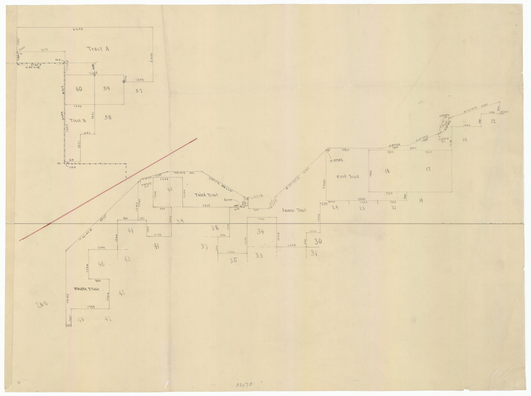
Bravo Deed, Instrument 24, Tract A and Tract B
180-56
-
Map/Doc
91480
-
Collection
Twichell Survey Records
-
Counties
Oldham
Part of: Twichell Survey Records
Ownership Map Midland Co., Texas

Ownership Map Midland Co., Texas
1951
Size 43.2 x 45.3 inches
Map/Doc 89914
Hockley County Sketch Mineral Application Number 38245

Print $20.00
- Digital $50.00
Hockley County Sketch Mineral Application Number 38245
1946
Size 40.6 x 18.5 inches
Map/Doc 92243
[Sketch of a portion of a Bastrop District GLO map]
![90240, [Sketch of a portion of a Bastrop District GLO map], Twichell Survey Records](https://historictexasmaps.com/wmedia_w700/maps/90240-1.tif.jpg)
Print $3.00
- Digital $50.00
[Sketch of a portion of a Bastrop District GLO map]
1923
Size 11.4 x 15.1 inches
Map/Doc 90240
[Northwest Garza County around John Walker and Thomas Hughes surveys]
![90848, [Northwest Garza County around John Walker and Thomas Hughes surveys], Twichell Survey Records](https://historictexasmaps.com/wmedia_w700/maps/90848-2.tif.jpg)
Print $20.00
- Digital $50.00
[Northwest Garza County around John Walker and Thomas Hughes surveys]
1913
Size 27.5 x 14.3 inches
Map/Doc 90848
Sketch showing the Fred Turner surveys in Pecos County, Texas

Print $20.00
- Digital $50.00
Sketch showing the Fred Turner surveys in Pecos County, Texas
1928
Size 28.9 x 36.0 inches
Map/Doc 91590
Section L Tech Memorial Park, Inc.

Print $3.00
- Digital $50.00
Section L Tech Memorial Park, Inc.
1950
Size 11.7 x 12.8 inches
Map/Doc 92270
Working Sketch Crockett County

Print $20.00
- Digital $50.00
Working Sketch Crockett County
1925
Size 16.6 x 15.2 inches
Map/Doc 90476

[Southwest part of County]
![90922, [Southwest part of County], Twichell Survey Records](https://historictexasmaps.com/wmedia_w700/maps/90922-1.tif.jpg)
Print $20.00
- Digital $50.00
[Southwest part of County]
Size 28.8 x 18.4 inches
Map/Doc 90922
Texas Boundary Line

Print $20.00
- Digital $50.00
Texas Boundary Line
Size 21.6 x 11.9 inches
Map/Doc 92078
[Block S Sections 20 and 24, Block I Sections 6 and 7]
![92851, [Block S Sections 20 and 24, Block I Sections 6 and 7], Twichell Survey Records](https://historictexasmaps.com/wmedia_w700/maps/92851-1.tif.jpg)
Print $20.00
- Digital $50.00
[Block S Sections 20 and 24, Block I Sections 6 and 7]
Size 22.8 x 19.0 inches
Map/Doc 92851
Subdivision of Outlots 1 and 2 in Original Townsite of Seagraves, Texas

Print $20.00
- Digital $50.00
Subdivision of Outlots 1 and 2 in Original Townsite of Seagraves, Texas
1955
Size 17.3 x 29.1 inches
Map/Doc 92688
You may also like
Lebanon Quadrangle

Print $20.00
- Digital $50.00
Lebanon Quadrangle
1999
Size 35.4 x 23.4 inches
Map/Doc 97360
PSL Field Notes for Blocks C13 and C14 in Jeff Davis and Reeves Counties, Block C17 in Culberson and Reeves Counties, and Blocks C11, C12, C15, C16, C18, C19, C20, and C21 in Reeves County

PSL Field Notes for Blocks C13 and C14 in Jeff Davis and Reeves Counties, Block C17 in Culberson and Reeves Counties, and Blocks C11, C12, C15, C16, C18, C19, C20, and C21 in Reeves County
Map/Doc 81672
Map Showing Colonel A.W. Doniphan's Route through the States of New Mexico, Chihuahua and Coahuila

Print $20.00
Map Showing Colonel A.W. Doniphan's Route through the States of New Mexico, Chihuahua and Coahuila
1847
Size 16.9 x 14.0 inches
Map/Doc 79729
Liberty County Rolled Sketch N

Print $20.00
- Digital $50.00
Liberty County Rolled Sketch N
Size 44.7 x 38.5 inches
Map/Doc 10180
Map of a part of Fisher and Miller's Colony - Harvey's District

Print $20.00
- Digital $50.00
Map of a part of Fisher and Miller's Colony - Harvey's District
1856
Size 15.2 x 19.8 inches
Map/Doc 1972
Ownership Map NW 1/4 Lubbock County

Print $20.00
- Digital $50.00
Ownership Map NW 1/4 Lubbock County
1926
Size 32.1 x 39.6 inches
Map/Doc 89696
Concho County Working Sketch 25

Print $20.00
- Digital $50.00
Concho County Working Sketch 25
1982
Size 32.3 x 38.1 inches
Map/Doc 68207
General Highway Map, Blanco County, Texas

Print $20.00
General Highway Map, Blanco County, Texas
1940
Size 25.0 x 18.5 inches
Map/Doc 79020
Milam County Boundary File 6a

Print $20.00
- Digital $50.00
Milam County Boundary File 6a
Size 9.5 x 29.0 inches
Map/Doc 57248
Crockett County Sketch File 92

Print $21.00
- Digital $50.00
Crockett County Sketch File 92
1925
Size 11.4 x 8.8 inches
Map/Doc 19937
Packery Channel

Print $20.00
- Digital $50.00
Packery Channel
1958
Size 29.5 x 37.5 inches
Map/Doc 2992
Map of Re-Survey of Blk. 34 & 35 T5N

Print $40.00
- Digital $50.00
Map of Re-Survey of Blk. 34 & 35 T5N
1915
Size 53.5 x 39.2 inches
Map/Doc 89765