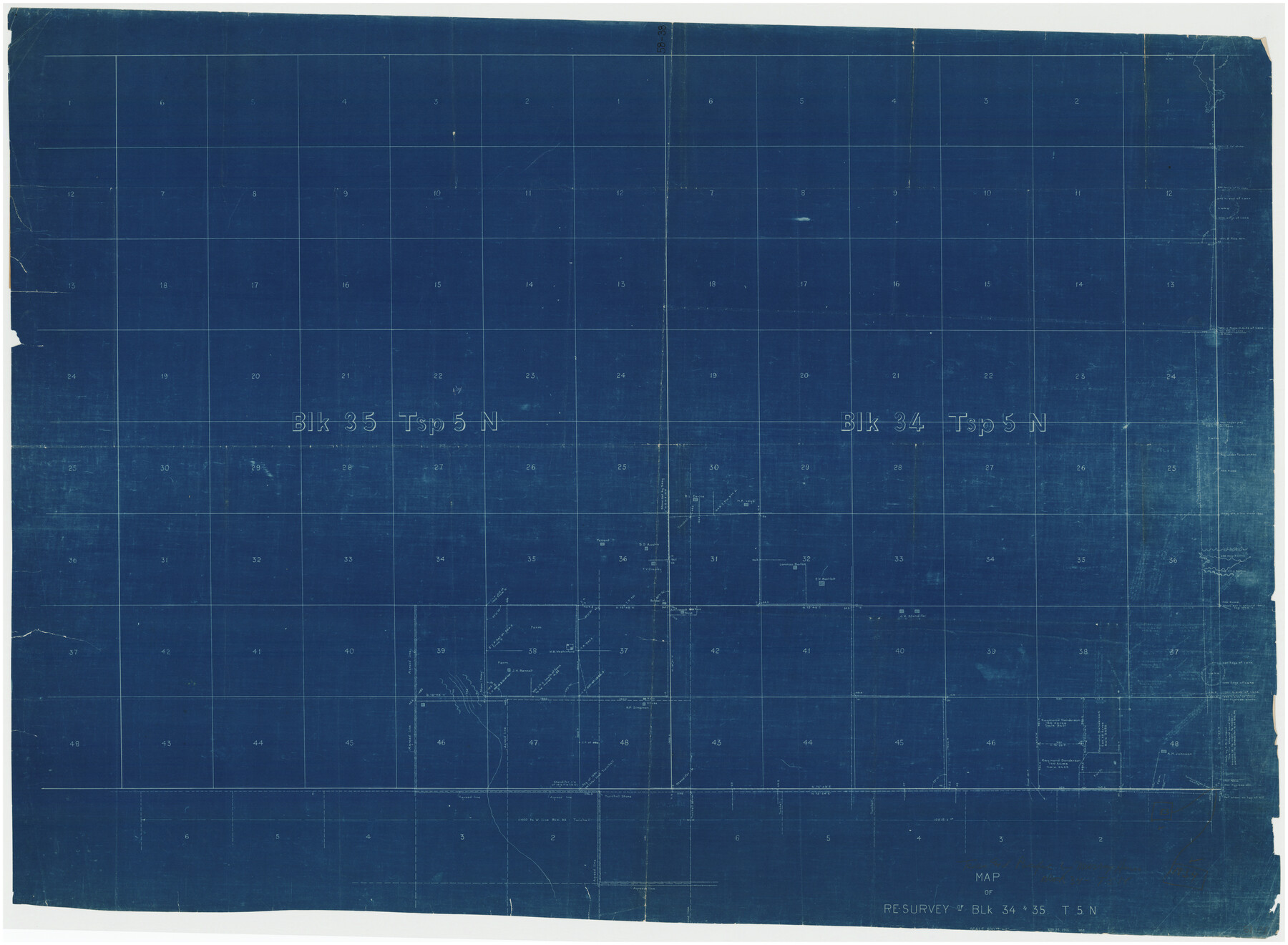
Map of Re-Survey of Blk. 34 & 35 T5N
58-38
-
Map/Doc
89765
-
Collection
Twichell Survey Records
-
Object Dates
11/23/1915 (Creation Date)
-
Counties
Dawson
-
Height x Width
53.5 x 39.2 inches
135.9 x 99.6 cm
Part of: Twichell Survey Records
New Hobbs Addition Lea County, New Mexico

Print $20.00
- Digital $50.00
New Hobbs Addition Lea County, New Mexico
1930
Size 30.6 x 18.9 inches
Map/Doc 92425
Map of Hale County, Texas

Print $2.00
- Digital $50.00
Map of Hale County, Texas
1903
Size 9.2 x 11.6 inches
Map/Doc 90698
![91464, [Block B7], Twichell Survey Records](https://historictexasmaps.com/wmedia_w700/maps/91464-1.tif.jpg)
Map [showing surveys 820-829] Along Red River
![89813, Map [showing surveys 820-829] Along Red River, Twichell Survey Records](https://historictexasmaps.com/wmedia_w700/maps/89813-1.tif.jpg)
Print $20.00
- Digital $50.00
Map [showing surveys 820-829] Along Red River
1920
Size 40.4 x 45.2 inches
Map/Doc 89813
[Blocks T2, T3, and K13]
![90989, [Blocks T2, T3, and K13], Twichell Survey Records](https://historictexasmaps.com/wmedia_w700/maps/90989-1.tif.jpg)
Print $20.00
- Digital $50.00
[Blocks T2, T3, and K13]
Size 20.6 x 19.8 inches
Map/Doc 90989
[Sketch showing C. D. & W. A. Murphy's Pasture and Wint Barfield's Pasture]
![90935, [Sketch showing C. D. & W. A. Murphy's Pasture and Wint Barfield's Pasture], Twichell Survey Records](https://historictexasmaps.com/wmedia_w700/maps/90935-1.tif.jpg)
Print $20.00
- Digital $50.00
[Sketch showing C. D. & W. A. Murphy's Pasture and Wint Barfield's Pasture]
Size 30.4 x 26.7 inches
Map/Doc 90935
[Part of Hutchison County]
![91144, [Part of Hutchison County], Twichell Survey Records](https://historictexasmaps.com/wmedia_w700/maps/91144-1.tif.jpg)
Print $2.00
- Digital $50.00
[Part of Hutchison County]
1875
Size 7.5 x 11.5 inches
Map/Doc 91144
[Castro, Lamb, Hockley, Swisher, Hale, and Lubbock Counties]
![91026, [Castro, Lamb, Hockley, Swisher, Hale, and Lubbock Counties], Twichell Survey Records](https://historictexasmaps.com/wmedia_w700/maps/91026-1.tif.jpg)
Print $20.00
- Digital $50.00
[Castro, Lamb, Hockley, Swisher, Hale, and Lubbock Counties]
Size 28.7 x 37.6 inches
Map/Doc 91026
[Borden County Lines - Description of County Line Markers]
![90215, [Borden County Lines - Description of County Line Markers], Twichell Survey Records](https://historictexasmaps.com/wmedia_w700/maps/90215-1.tif.jpg)
Print $3.00
- Digital $50.00
[Borden County Lines - Description of County Line Markers]
Size 14.4 x 10.1 inches
Map/Doc 90215
Replat of Baker 2nd Addition to Lamesa, Part of Southwest Quarter, Section 71, Block 35, Dawson County, Texas

Print $20.00
- Digital $50.00
Replat of Baker 2nd Addition to Lamesa, Part of Southwest Quarter, Section 71, Block 35, Dawson County, Texas
1958
Size 9.2 x 18.0 inches
Map/Doc 92630
[H. & G. N. RR. Co. Block 1]
![90888, [H. & G. N. RR. Co. Block 1], Twichell Survey Records](https://historictexasmaps.com/wmedia_w700/maps/90888-1.tif.jpg)
Print $20.00
- Digital $50.00
[H. & G. N. RR. Co. Block 1]
Size 37.1 x 43.6 inches
Map/Doc 90888
[Blocks L. E. and B8]
![90666, [Blocks L. E. and B8], Twichell Survey Records](https://historictexasmaps.com/wmedia_w700/maps/90666-2.tif.jpg)
Print $20.00
- Digital $50.00
[Blocks L. E. and B8]
Size 18.4 x 13.6 inches
Map/Doc 90666
You may also like
Angelina County Sketch File 15f

Print $4.00
- Digital $50.00
Angelina County Sketch File 15f
Size 10.4 x 7.6 inches
Map/Doc 12994
Map of surveys 191 & 192 T. C. R.R. Co. in Travis County, Texas

Print $20.00
- Digital $50.00
Map of surveys 191 & 192 T. C. R.R. Co. in Travis County, Texas
1915
Size 20.6 x 13.6 inches
Map/Doc 75554
Flight Mission No. BRA-8M, Frame 133, Jefferson County

Print $20.00
- Digital $50.00
Flight Mission No. BRA-8M, Frame 133, Jefferson County
1953
Size 18.7 x 22.3 inches
Map/Doc 85629
Presidio County Rolled Sketch 83B

Print $20.00
- Digital $50.00
Presidio County Rolled Sketch 83B
Size 16.6 x 23.0 inches
Map/Doc 2061
[Leagues 656-666, 671-676, 684-688, 692-695]
![91007, [Leagues 656-666, 671-676, 684-688, 692-695], Twichell Survey Records](https://historictexasmaps.com/wmedia_w700/maps/91007-1.tif.jpg)
Print $20.00
- Digital $50.00
[Leagues 656-666, 671-676, 684-688, 692-695]
Size 30.6 x 20.7 inches
Map/Doc 91007
Map of Titus County

Print $20.00
- Digital $50.00
Map of Titus County
1857
Size 24.1 x 34.5 inches
Map/Doc 83380
Flight Mission No. BRA-6M, Frame 88, Jefferson County

Print $20.00
- Digital $50.00
Flight Mission No. BRA-6M, Frame 88, Jefferson County
1953
Size 18.4 x 22.4 inches
Map/Doc 85431
Newton County Sketch File 5

Print $8.00
- Digital $50.00
Newton County Sketch File 5
Size 8.2 x 12.8 inches
Map/Doc 32368
Orange County Working Sketch 50

Print $20.00
- Digital $50.00
Orange County Working Sketch 50
1991
Size 36.0 x 43.6 inches
Map/Doc 71382
Tom Green County

Print $20.00
- Digital $50.00
Tom Green County
1873
Size 22.4 x 36.9 inches
Map/Doc 1551
General Highway Map. Detail of Cities and Towns in Hardin County, Texas [Silsbee and vicinity]
![79500, General Highway Map. Detail of Cities and Towns in Hardin County, Texas [Silsbee and vicinity], Texas State Library and Archives](https://historictexasmaps.com/wmedia_w700/maps/79500.tif.jpg)
Print $20.00
General Highway Map. Detail of Cities and Towns in Hardin County, Texas [Silsbee and vicinity]
1961
Size 18.1 x 24.7 inches
Map/Doc 79500
[Surveys on Galveston and East Bay]
![248, [Surveys on Galveston and East Bay], General Map Collection](https://historictexasmaps.com/wmedia_w700/maps/248.tif.jpg)
Print $2.00
- Digital $50.00
[Surveys on Galveston and East Bay]
1846
Size 8.8 x 7.9 inches
Map/Doc 248