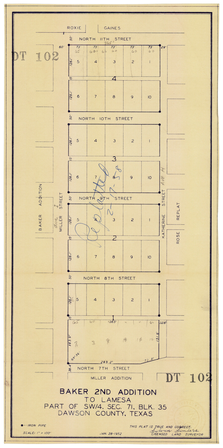
Replat of Baker 2nd Addition to Lamesa, Part of Southwest Quarter, Section 71, Block 35, Dawson County, Texas
DT102
-
Map/Doc
92630
-
Collection
Twichell Survey Records
-
Object Dates
2/15/1958 (Creation Date)
-
People and Organizations
John N. Cinelli (Surveyor/Engineer)
-
Counties
Dawson
-
Height x Width
9.2 x 18.0 inches
23.4 x 45.7 cm
Part of: Twichell Survey Records
Olton, Texas Voted County Seat of Lamb County

Print $20.00
- Digital $50.00
Olton, Texas Voted County Seat of Lamb County
Size 23.2 x 24.1 inches
Map/Doc 92151
J. B. McCauley Farm Section 17, Block AK

Print $20.00
- Digital $50.00
J. B. McCauley Farm Section 17, Block AK
Size 22.9 x 27.3 inches
Map/Doc 92297
[Leagues 247, 320, and 321]
![91291, [Leagues 247, 320, and 321], Twichell Survey Records](https://historictexasmaps.com/wmedia_w700/maps/91291-1.tif.jpg)
Print $2.00
- Digital $50.00
[Leagues 247, 320, and 321]
Size 8.2 x 15.1 inches
Map/Doc 91291
Map of Terry County

Print $20.00
- Digital $50.00
Map of Terry County
1917
Size 17.7 x 22.6 inches
Map/Doc 91874
[Hockley County Sketch, Mineral Application Number 38322- 38379]
![91203, [Hockley County Sketch, Mineral Application Number 38322- 38379], Twichell Survey Records](https://historictexasmaps.com/wmedia_w700/maps/91203-1.tif.jpg)
Print $20.00
- Digital $50.00
[Hockley County Sketch, Mineral Application Number 38322- 38379]
1946
Size 43.5 x 26.7 inches
Map/Doc 91203
[H. & G. N. RR. Co. Block 1]
![90889, [H. & G. N. RR. Co. Block 1], Twichell Survey Records](https://historictexasmaps.com/wmedia_w700/maps/90889-1.tif.jpg)
Print $20.00
- Digital $50.00
[H. & G. N. RR. Co. Block 1]
Size 16.5 x 27.9 inches
Map/Doc 90889
[Sketch showing I. & G. N. Block 8]
![91798, [Sketch showing I. & G. N. Block 8], Twichell Survey Records](https://historictexasmaps.com/wmedia_w700/maps/91798-1.tif.jpg)
Print $2.00
- Digital $50.00
[Sketch showing I. & G. N. Block 8]
1919
Size 7.6 x 12.6 inches
Map/Doc 91798
Leila Y. Post Montgomery & Marjorie Post Hutton's Subdivision of Hall County School Land Leagues 158-159-N 1/2 157, Cochran County, Texas

Print $20.00
- Digital $50.00
Leila Y. Post Montgomery & Marjorie Post Hutton's Subdivision of Hall County School Land Leagues 158-159-N 1/2 157, Cochran County, Texas
Size 8.4 x 18.4 inches
Map/Doc 90456
[Capitol Leagues along New Mexico Line]
![90766, [Capitol Leagues along New Mexico Line], Twichell Survey Records](https://historictexasmaps.com/wmedia_w700/maps/90766-1.tif.jpg)
Print $20.00
- Digital $50.00
[Capitol Leagues along New Mexico Line]
Size 8.2 x 22.7 inches
Map/Doc 90766
[Part of Eastern Texas RR. Co. Block 1]
![91921, [Part of Eastern Texas RR. Co. Block 1], Twichell Survey Records](https://historictexasmaps.com/wmedia_w700/maps/91921-1.tif.jpg)
Print $20.00
- Digital $50.00
[Part of Eastern Texas RR. Co. Block 1]
Size 23.9 x 43.1 inches
Map/Doc 91921
[Blocks 3T, 1, and 6T]
![91421, [Blocks 3T, 1, and 6T], Twichell Survey Records](https://historictexasmaps.com/wmedia_w700/maps/91421-1.tif.jpg)
Print $20.00
- Digital $50.00
[Blocks 3T, 1, and 6T]
Size 26.2 x 25.7 inches
Map/Doc 91421
Map of Edwards County, Texas

Print $20.00
- Digital $50.00
Map of Edwards County, Texas
Size 21.5 x 18.2 inches
Map/Doc 92635
You may also like
Baylor County Sketch File 15

Print $6.00
- Digital $50.00
Baylor County Sketch File 15
1879
Size 13.0 x 8.4 inches
Map/Doc 14183
Schleicher County Sketch File 40

Print $6.00
- Digital $50.00
Schleicher County Sketch File 40
1958
Size 11.2 x 8.9 inches
Map/Doc 36541
Delta County, Texas

Print $20.00
- Digital $50.00
Delta County, Texas
1884
Size 14.1 x 20.0 inches
Map/Doc 416
Lubbock County Working Sketch 8

Print $20.00
- Digital $50.00
Lubbock County Working Sketch 8
1989
Size 27.4 x 25.2 inches
Map/Doc 70668
Sabine County Working Sketch 4

Print $20.00
- Digital $50.00
Sabine County Working Sketch 4
1913
Size 23.7 x 32.0 inches
Map/Doc 63675
Red River County Working Sketch 37

Print $20.00
- Digital $50.00
Red River County Working Sketch 37
1964
Size 31.1 x 34.8 inches
Map/Doc 72020
Flight Mission No. CRC-5R, Frame 23, Chambers County

Print $20.00
- Digital $50.00
Flight Mission No. CRC-5R, Frame 23, Chambers County
1956
Size 18.8 x 22.4 inches
Map/Doc 84945
Chambers County Sketch File 24

Print $20.00
- Digital $50.00
Chambers County Sketch File 24
1909
Size 34.1 x 14.5 inches
Map/Doc 11065
[Beaumont, Sour Lake and Western Ry. Right of Way and Alignment - Frisco]
![64111, [Beaumont, Sour Lake and Western Ry. Right of Way and Alignment - Frisco], General Map Collection](https://historictexasmaps.com/wmedia_w700/maps/64111.tif.jpg)
Print $20.00
- Digital $50.00
[Beaumont, Sour Lake and Western Ry. Right of Way and Alignment - Frisco]
1910
Size 19.8 x 45.9 inches
Map/Doc 64111
Rockwall County Boundary File 8

Print $10.00
- Digital $50.00
Rockwall County Boundary File 8
Size 14.4 x 8.8 inches
Map/Doc 58428
Map of Palo Pinto County, east of the Brazos River, Robertson - west of it, Milam Land District

Print $20.00
- Digital $50.00
Map of Palo Pinto County, east of the Brazos River, Robertson - west of it, Milam Land District
1859
Size 27.4 x 22.3 inches
Map/Doc 3935
