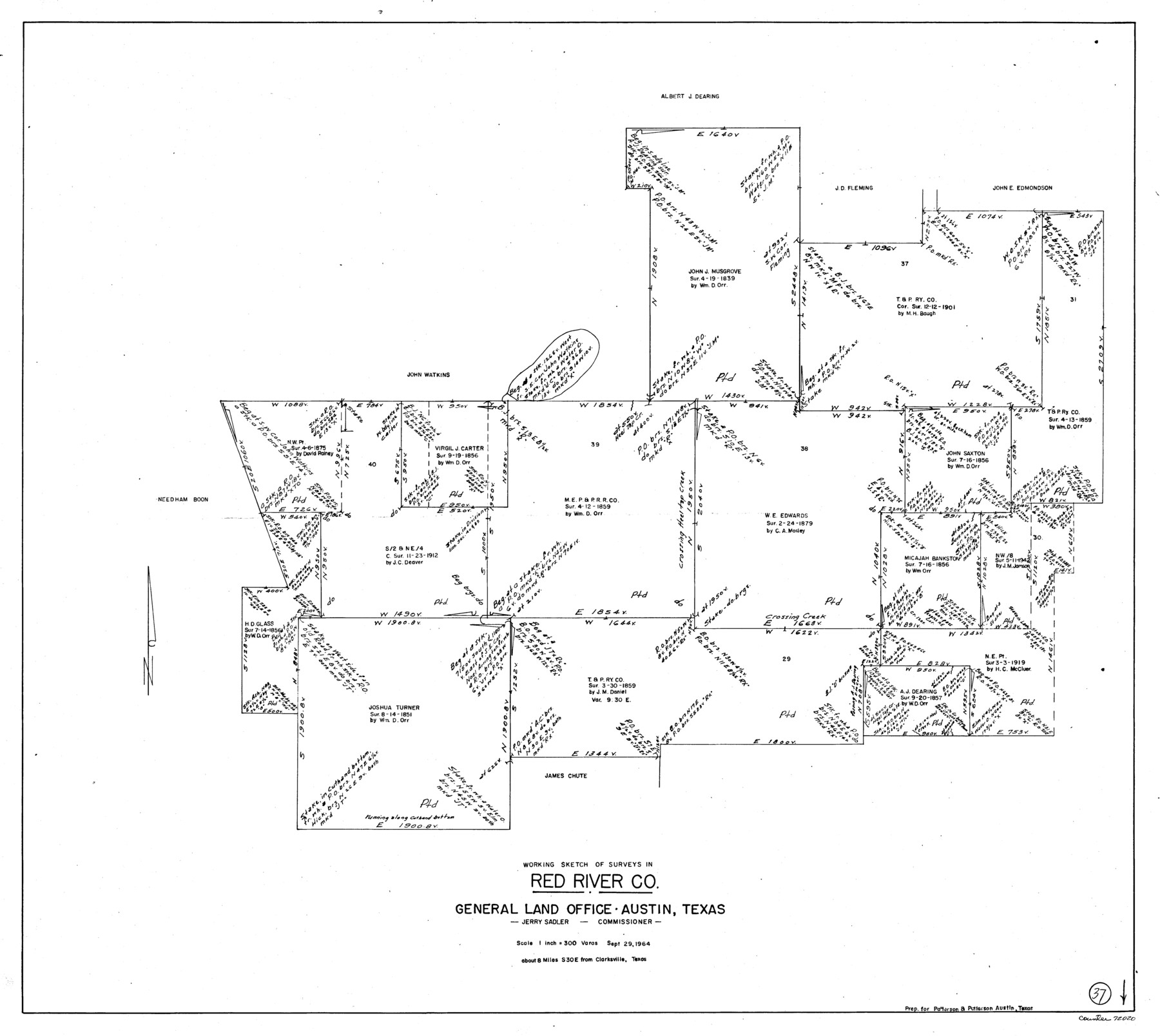
Red River County Working Sketch 37
-
Map/Doc
72020
-
Collection
General Map Collection
-
Object Dates
9/29/1964 (Creation Date)
-
Counties
Red River
-
Subjects
Surveying Working Sketch
-
Height x Width
31.1 x 34.8 inches
79.0 x 88.4 cm
-
Scale
1" = 300 varas
Part of: General Map Collection
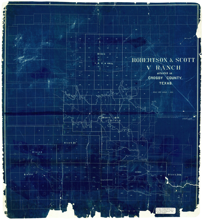
Crosby County Rolled Sketch V
Print $20.00
- Digital $50.00
Crosby County Rolled Sketch V
Size 45.4 x 41.8 inches
Map/Doc 8739
Sutton County Working Sketch 67

Print $20.00
- Digital $50.00
Sutton County Working Sketch 67
1972
Size 37.7 x 36.7 inches
Map/Doc 62410
Kendall County Working Sketch 4

Print $20.00
- Digital $50.00
Kendall County Working Sketch 4
1946
Size 25.7 x 24.3 inches
Map/Doc 66676
Smith County Sketch File 4

Print $4.00
- Digital $50.00
Smith County Sketch File 4
1853
Size 10.3 x 8.1 inches
Map/Doc 36752
Grayson County Boundary File 2a

Print $60.00
- Digital $50.00
Grayson County Boundary File 2a
Size 43.7 x 9.8 inches
Map/Doc 53938
Reagan County Rolled Sketch 8

Print $20.00
- Digital $50.00
Reagan County Rolled Sketch 8
Size 30.2 x 26.7 inches
Map/Doc 7436
Taylor County Working Sketch 16

Print $20.00
- Digital $50.00
Taylor County Working Sketch 16
1981
Size 28.8 x 41.2 inches
Map/Doc 69626
Sutton County Working Sketch 22

Print $20.00
- Digital $50.00
Sutton County Working Sketch 22
1981
Size 33.7 x 33.4 inches
Map/Doc 62365
Kendall County Working Sketch 16

Print $20.00
- Digital $50.00
Kendall County Working Sketch 16
1967
Size 28.0 x 29.1 inches
Map/Doc 66688
Travis County Sketch File 36

Print $4.00
- Digital $50.00
Travis County Sketch File 36
1912
Size 8.4 x 9.9 inches
Map/Doc 38355
Comanche County Working Sketch 12

Print $20.00
- Digital $50.00
Comanche County Working Sketch 12
1957
Size 15.4 x 25.5 inches
Map/Doc 68146
Kerr County Working Sketch 18

Print $20.00
- Digital $50.00
Kerr County Working Sketch 18
1956
Size 25.4 x 29.3 inches
Map/Doc 70049
You may also like
Upper Galveston Bay, Houston Ship Channel, Dollar Pt. to Atkinson I.

Print $40.00
- Digital $50.00
Upper Galveston Bay, Houston Ship Channel, Dollar Pt. to Atkinson I.
1973
Size 49.8 x 36.8 inches
Map/Doc 69896
McLennan County Sketch File 4

Print $4.00
- Digital $50.00
McLennan County Sketch File 4
1852
Size 12.7 x 8.2 inches
Map/Doc 31235
Map of Jefferson County

Print $20.00
- Digital $50.00
Map of Jefferson County
1840
Size 34.8 x 27.0 inches
Map/Doc 3726
Topographical Map of the country between San Antonio & Colorado Rivers in the State of Texas.

Print $40.00
Topographical Map of the country between San Antonio & Colorado Rivers in the State of Texas.
1864
Size 53.4 x 69.8 inches
Map/Doc 88605
Carte de la Louisiane et du Cours du Mississipi

Print $20.00
- Digital $50.00
Carte de la Louisiane et du Cours du Mississipi
1718
Size 20.6 x 27.3 inches
Map/Doc 93821
Wichita County Working Sketch 26

Print $20.00
- Digital $50.00
Wichita County Working Sketch 26
1981
Size 13.1 x 21.0 inches
Map/Doc 72536
Working Sketch in Gray, Donley, and Carson Counties, Texas

Print $20.00
- Digital $50.00
Working Sketch in Gray, Donley, and Carson Counties, Texas
1909
Size 22.7 x 27.0 inches
Map/Doc 90779
Glasscock County Rolled Sketch 1

Print $20.00
- Digital $50.00
Glasscock County Rolled Sketch 1
1906
Size 37.3 x 33.6 inches
Map/Doc 9055
Reagan County Working Sketch 31

Print $20.00
- Digital $50.00
Reagan County Working Sketch 31
1964
Size 38.7 x 36.6 inches
Map/Doc 71873
Hutchinson County Working Sketch 2

Print $20.00
- Digital $50.00
Hutchinson County Working Sketch 2
Size 32.0 x 18.9 inches
Map/Doc 66360
Jim Hogg County Rolled Sketch 9

Print $20.00
- Digital $50.00
Jim Hogg County Rolled Sketch 9
1974
Size 18.2 x 19.8 inches
Map/Doc 6443
Map of the lower surveys in Robertsons Colony Sold by the State of Coahuila and Texas

Print $20.00
- Digital $50.00
Map of the lower surveys in Robertsons Colony Sold by the State of Coahuila and Texas
1834
Size 22.0 x 28.5 inches
Map/Doc 122