Glasscock County Rolled Sketch 1
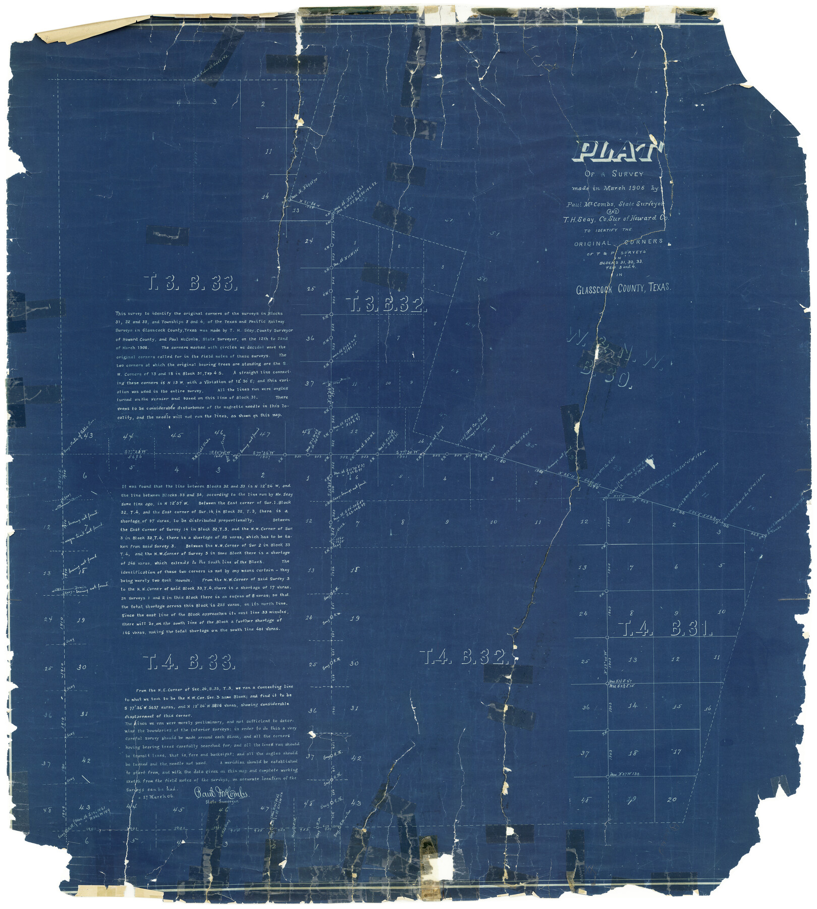
Plat of a survey made in March 1906 by Paul McCombs, State Surveyor, and T.H. Seay, Co. Sur. of Howard Co. to identify the original corners of T. & P. surveys in Blocks 31, 32, 33, Tsp. 3 and 4
-
Map/Doc
9055
-
Collection
General Map Collection
-
Object Dates
3/27/1906 (Creation Date)
7/27/1906 (File Date)
-
People and Organizations
Paul McCombs (Surveyor/Engineer)
T.H. Seay (Surveyor/Engineer)
-
Counties
Glasscock
-
Subjects
Surveying Rolled Sketch
-
Height x Width
37.3 x 33.6 inches
94.7 x 85.3 cm
-
Medium
blueprint/diazo
Part of: General Map Collection
Menard County Sketch File 3

Print $40.00
- Digital $50.00
Menard County Sketch File 3
Size 16.3 x 12.9 inches
Map/Doc 31488
Concho County Working Sketch 21

Print $20.00
- Digital $50.00
Concho County Working Sketch 21
1957
Size 36.4 x 36.0 inches
Map/Doc 68203
Map of Jefferson County

Print $20.00
- Digital $50.00
Map of Jefferson County
1840
Size 34.8 x 27.0 inches
Map/Doc 3726
Runnels County Rolled Sketch 51

Print $20.00
- Digital $50.00
Runnels County Rolled Sketch 51
Size 26.1 x 34.3 inches
Map/Doc 7536
State Land for Sale on Mustang Island

Print $20.00
- Digital $50.00
State Land for Sale on Mustang Island
1910
Size 28.8 x 20.3 inches
Map/Doc 719
Sabine County Working Sketch 15

Print $20.00
- Digital $50.00
Sabine County Working Sketch 15
1957
Size 21.2 x 34.9 inches
Map/Doc 63686
Rusk County Sketch File 43

Print $20.00
Rusk County Sketch File 43
1951
Size 23.5 x 26.6 inches
Map/Doc 12278
St. Louis, Brownsville & Mexico

Print $40.00
- Digital $50.00
St. Louis, Brownsville & Mexico
1906
Size 21.2 x 130.5 inches
Map/Doc 89280
Kaufman County

Print $40.00
- Digital $50.00
Kaufman County
1942
Size 50.0 x 41.0 inches
Map/Doc 95552
Bowie County Sketch File 6b

Print $40.00
- Digital $50.00
Bowie County Sketch File 6b
Size 14.4 x 13.5 inches
Map/Doc 14848
Upton County Rolled Sketch 16

Print $20.00
- Digital $50.00
Upton County Rolled Sketch 16
1927
Size 18.9 x 37.7 inches
Map/Doc 8071
Edwards County Working Sketch 18

Print $20.00
- Digital $50.00
Edwards County Working Sketch 18
1931
Size 34.3 x 37.0 inches
Map/Doc 68894
You may also like
Sunset, Montague Co., Texas

Print $20.00
Sunset, Montague Co., Texas
1890
Size 9.7 x 14.5 inches
Map/Doc 89209
Grid Map Showing Texas, Louisiana, Arkansas, Mississippi and portions of New Mexico, Oklahoma and Tennessee

Print $40.00
- Digital $50.00
Grid Map Showing Texas, Louisiana, Arkansas, Mississippi and portions of New Mexico, Oklahoma and Tennessee
1940
Size 34.2 x 48.1 inches
Map/Doc 3121
Presidio County Working Sketch 132

Print $20.00
- Digital $50.00
Presidio County Working Sketch 132
1989
Size 36.7 x 29.4 inches
Map/Doc 71810
Map of the Military Department of the Gulf

Print $20.00
Map of the Military Department of the Gulf
1864
Size 24.4 x 45.7 inches
Map/Doc 93568
Gaines County Sketch File 4

Print $4.00
- Digital $50.00
Gaines County Sketch File 4
1902
Size 14.3 x 8.5 inches
Map/Doc 23175
[Kent County Block 4, Sections 33 and 46, Block 97, Sections 771 and 772]
![92192, [Kent County Block 4, Sections 33 and 46, Block 97, Sections 771 and 772], Twichell Survey Records](https://historictexasmaps.com/wmedia_w700/maps/92192-1.tif.jpg)
Print $2.00
- Digital $50.00
[Kent County Block 4, Sections 33 and 46, Block 97, Sections 771 and 772]
1951
Size 8.7 x 15.6 inches
Map/Doc 92192
Flight Mission No. DAG-17K, Frame 75, Matagorda County

Print $20.00
- Digital $50.00
Flight Mission No. DAG-17K, Frame 75, Matagorda County
1952
Size 16.5 x 16.5 inches
Map/Doc 86334
Harris County Sketch File E

Print $4.00
- Digital $50.00
Harris County Sketch File E
1860
Size 7.6 x 12.1 inches
Map/Doc 25315
Map of Atascosa Co.

Print $40.00
- Digital $50.00
Map of Atascosa Co.
1894
Size 48.3 x 46.6 inches
Map/Doc 4877
Flight Mission No. DAG-22K, Frame 87, Matagorda County

Print $20.00
- Digital $50.00
Flight Mission No. DAG-22K, Frame 87, Matagorda County
1953
Size 18.6 x 22.4 inches
Map/Doc 86471
Mexico y sus Cercanias

Print $20.00
- Digital $50.00
Mexico y sus Cercanias
Size 26.1 x 34.2 inches
Map/Doc 96809
The Republic County of Lamar. December 26, 1842

Print $20.00
The Republic County of Lamar. December 26, 1842
2020
Size 16.4 x 21.7 inches
Map/Doc 96205