Presidio County Rolled Sketch 83B
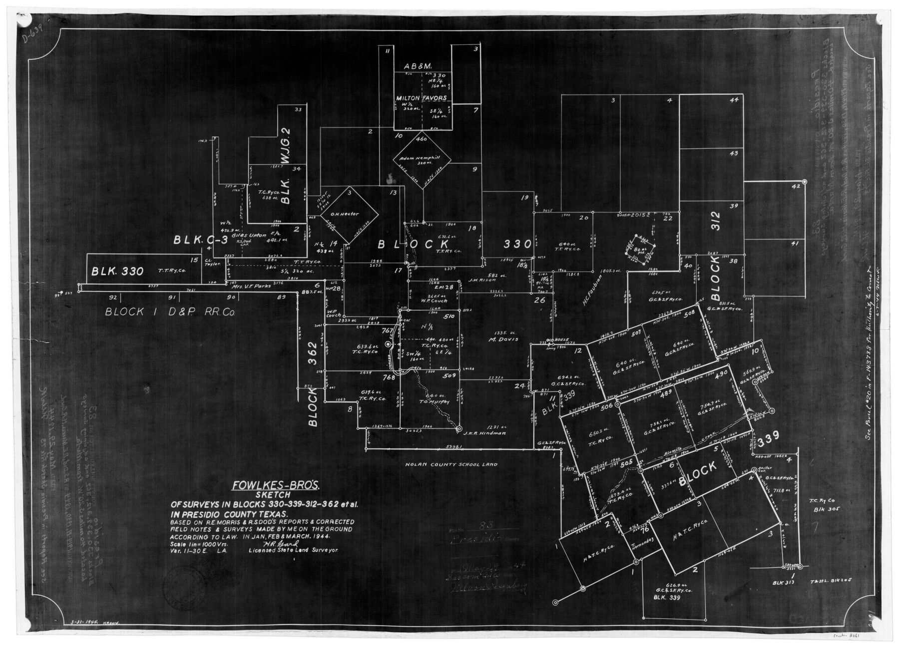
Fowlkes-Bros. sketch of surveys in Blocks 330, 339, 312, 362 et al in Presidio County, Texas based on R.E. Morris & R.S. Dod's reports & corrected field notes & surveys
-
Map/Doc
2061
-
Collection
General Map Collection
-
Object Dates
3/1944 (Survey Date)
5/29/1944 (File Date)
-
People and Organizations
H.R. Gard (Surveyor/Engineer)
-
Counties
Presidio
-
Subjects
Surveying Rolled Sketch
-
Height x Width
16.6 x 23.0 inches
42.2 x 58.4 cm
-
Medium
photostat
-
Scale
1" = 1000 varas
-
Comments
See Presidio County Sketch File 73 (34682) for report and see Presidio County Rolled Sketch 83A (7370) for related sketch.
Related maps
Presidio County Sketch File 73

Print $11.00
- Digital $50.00
Presidio County Sketch File 73
1944
Size 11.4 x 8.8 inches
Map/Doc 34682
Presidio County Rolled Sketch 83A

Print $20.00
- Digital $50.00
Presidio County Rolled Sketch 83A
1930
Size 28.2 x 27.6 inches
Map/Doc 7370
Part of: General Map Collection
Fort Bend County State Real Property Sketch 12

Print $40.00
- Digital $50.00
Fort Bend County State Real Property Sketch 12
1986
Size 43.2 x 35.0 inches
Map/Doc 61686
Kleberg County Rolled Sketch 10-7

Print $20.00
- Digital $50.00
Kleberg County Rolled Sketch 10-7
1953
Size 37.3 x 34.5 inches
Map/Doc 9401
[Sketch for Mineral Application 26501 - Sabine River, T. A. Oldhausen]
![2843, [Sketch for Mineral Application 26501 - Sabine River, T. A. Oldhausen], General Map Collection](https://historictexasmaps.com/wmedia_w700/maps/2843.tif.jpg)
Print $20.00
- Digital $50.00
[Sketch for Mineral Application 26501 - Sabine River, T. A. Oldhausen]
1931
Size 23.8 x 36.2 inches
Map/Doc 2843
Flight Mission No. BRA-16M, Frame 72, Jefferson County

Print $20.00
- Digital $50.00
Flight Mission No. BRA-16M, Frame 72, Jefferson County
1953
Size 18.5 x 22.4 inches
Map/Doc 85689
Panola County Sketch File 9

Print $8.00
- Digital $50.00
Panola County Sketch File 9
Size 13.9 x 8.5 inches
Map/Doc 33461
Flight Mission No. BRA-7M, Frame 76, Jefferson County

Print $20.00
- Digital $50.00
Flight Mission No. BRA-7M, Frame 76, Jefferson County
1953
Size 18.8 x 22.3 inches
Map/Doc 85498
[Map of Nacogdoches County]
![93368, [Map of Nacogdoches County], General Map Collection](https://historictexasmaps.com/wmedia_w700/maps/93368-1.tif.jpg)
Print $40.00
- Digital $50.00
[Map of Nacogdoches County]
1840
Size 79.3 x 38.0 inches
Map/Doc 93368
Real County Working Sketch 81

Print $20.00
- Digital $50.00
Real County Working Sketch 81
1984
Size 19.9 x 17.1 inches
Map/Doc 71973
Knox County Rolled Sketch 18

Print $20.00
- Digital $50.00
Knox County Rolled Sketch 18
1945
Size 23.1 x 29.5 inches
Map/Doc 6558
Uvalde County Working Sketch Graphic Index

Print $20.00
- Digital $50.00
Uvalde County Working Sketch Graphic Index
1976
Size 42.5 x 46.2 inches
Map/Doc 76723
Uvalde County Sketch File 15a

Print $20.00
- Digital $50.00
Uvalde County Sketch File 15a
1890
Size 13.2 x 16.7 inches
Map/Doc 12530

You may also like
Shelby County Working Sketch 14

Print $20.00
- Digital $50.00
Shelby County Working Sketch 14
1948
Size 28.5 x 22.3 inches
Map/Doc 63867
Denton County Working Sketch 10

Print $20.00
- Digital $50.00
Denton County Working Sketch 10
1960
Size 30.2 x 25.0 inches
Map/Doc 68615
[Resurvey of Block Number 01- W. H. Godair Surveys]
![92585, [Resurvey of Block Number 01- W. H. Godair Surveys], Twichell Survey Records](https://historictexasmaps.com/wmedia_w700/maps/92585-1.tif.jpg)
Print $20.00
- Digital $50.00
[Resurvey of Block Number 01- W. H. Godair Surveys]
1923
Size 33.9 x 14.9 inches
Map/Doc 92585
Smith Co. showing location of Texas and Pacific Railway

Print $20.00
- Digital $50.00
Smith Co. showing location of Texas and Pacific Railway
1872
Size 19.5 x 21.6 inches
Map/Doc 64139
Nueces County Sketch File 4

Print $4.00
- Digital $50.00
Nueces County Sketch File 4
1848
Size 10.1 x 8.0 inches
Map/Doc 32505
Collingsworth County Working Sketch 4

Print $20.00
- Digital $50.00
Collingsworth County Working Sketch 4
1960
Size 42.6 x 17.3 inches
Map/Doc 68092
Baylor County Rolled Sketch 8

Print $20.00
- Digital $50.00
Baylor County Rolled Sketch 8
1883
Size 12.9 x 18.4 inches
Map/Doc 5124
Padre Island National Seashore, Texas - Dependent Resurvey

Print $4.00
- Digital $50.00
Padre Island National Seashore, Texas - Dependent Resurvey
2001
Size 18.3 x 24.4 inches
Map/Doc 60545
Kent County Rolled Sketch 6

Print $20.00
- Digital $50.00
Kent County Rolled Sketch 6
Size 39.0 x 36.5 inches
Map/Doc 6476
Webb County Rolled Sketch 50

Print $20.00
- Digital $50.00
Webb County Rolled Sketch 50
1943
Size 38.2 x 42.6 inches
Map/Doc 10125
A Map of that part of Young District south of old Fannin District line

Print $20.00
- Digital $50.00
A Map of that part of Young District south of old Fannin District line
1861
Size 24.9 x 38.0 inches
Map/Doc 1979
Fayette County

Print $40.00
- Digital $50.00
Fayette County
1920
Size 42.7 x 49.8 inches
Map/Doc 4945