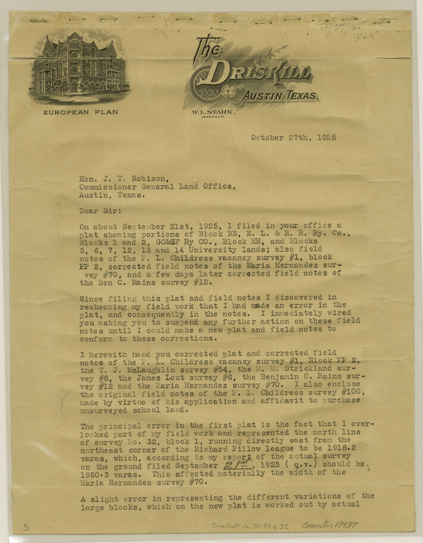
Crockett County Sketch File 92
[Field notes and correspondence regarding multiple surveys]
-
Map/Doc
19937
-
Collection
General Map Collection
-
Object Dates
1925/10/27 (Creation Date)
1925/9/21 (File Date)
1925 (Survey Date)
-
People and Organizations
Frank F. Friend (Surveyor/Engineer)
Herman Hubby (Chainman)
Jas. Swann (Chainman)
-
Counties
Crockett
-
Subjects
Surveying Sketch File
-
Height x Width
11.4 x 8.8 inches
29.0 x 22.4 cm
-
Medium
multi-page, multi-format
-
Scale
1:1000
-
Features
Live Oak Creek
Pecos River
Part of: General Map Collection
Hartley County Rolled Sketch 7

Print $20.00
- Digital $50.00
Hartley County Rolled Sketch 7
1952
Size 24.2 x 27.4 inches
Map/Doc 6161

Jasper County Rolled Sketch 2

Print $20.00
- Digital $50.00
Jasper County Rolled Sketch 2
1941
Size 37.9 x 24.1 inches
Map/Doc 6349
Reeves County Working Sketch 45

Print $20.00
- Digital $50.00
Reeves County Working Sketch 45
1974
Size 46.9 x 32.3 inches
Map/Doc 63488
Nueces County Sketch File 86

Print $2.00
- Digital $50.00
Nueces County Sketch File 86
Map/Doc 81935
Van Zandt County Sketch File 34

Print $4.00
- Digital $50.00
Van Zandt County Sketch File 34
1861
Size 7.8 x 15.0 inches
Map/Doc 39472
Denton County Boundary File 3

Print $34.00
- Digital $50.00
Denton County Boundary File 3
Size 6.1 x 3.9 inches
Map/Doc 52424
Uvalde County Sketch File 20

Print $40.00
- Digital $50.00
Uvalde County Sketch File 20
1882
Size 15.0 x 13.2 inches
Map/Doc 39002
Pecos County Rolled Sketch 101

Print $20.00
- Digital $50.00
Pecos County Rolled Sketch 101
1938
Size 22.5 x 39.0 inches
Map/Doc 7249
Copy of Surveyor's Field Book, Morris Browning - In Blocks 7, 5 & 4, I&GNRRCo., Hutchinson and Carson Counties, Texas

Print $2.00
- Digital $50.00
Copy of Surveyor's Field Book, Morris Browning - In Blocks 7, 5 & 4, I&GNRRCo., Hutchinson and Carson Counties, Texas
1888
Size 7.0 x 8.9 inches
Map/Doc 62268
Clay County Sketch File 7

Print $2.00
- Digital $50.00
Clay County Sketch File 7
Size 8.2 x 3.5 inches
Map/Doc 18397
Hamilton County Working Sketch 10

Print $20.00
- Digital $50.00
Hamilton County Working Sketch 10
1946
Size 30.6 x 24.6 inches
Map/Doc 63348
You may also like
Flight Mission No. DAG-28K, Frame 29, Matagorda County

Print $20.00
- Digital $50.00
Flight Mission No. DAG-28K, Frame 29, Matagorda County
1953
Size 16.2 x 16.1 inches
Map/Doc 86597

Pecos County Rolled Sketch 112

Print $20.00
- Digital $50.00
Pecos County Rolled Sketch 112
1941
Size 39.0 x 37.0 inches
Map/Doc 9720
Stonewall County Sketch File 8

Print $14.00
- Digital $50.00
Stonewall County Sketch File 8
1896
Size 8.7 x 7.7 inches
Map/Doc 37222
Atascosa County Working Sketch 39

Print $20.00
- Digital $50.00
Atascosa County Working Sketch 39
2011
Size 43.2 x 34.8 inches
Map/Doc 90068
Wilson County Working Sketch 5

Print $20.00
- Digital $50.00
Wilson County Working Sketch 5
1954
Size 32.4 x 33.9 inches
Map/Doc 72585
Sulphur River, Ringo Crossing Sheet

Print $20.00
- Digital $50.00
Sulphur River, Ringo Crossing Sheet
1933
Size 18.5 x 20.4 inches
Map/Doc 78334
Dallas County Sketch File 8

Print $5.00
- Digital $50.00
Dallas County Sketch File 8
1858
Size 16.3 x 9.1 inches
Map/Doc 20410
Wood County Working Sketch 15

Print $20.00
- Digital $50.00
Wood County Working Sketch 15
1981
Size 25.7 x 31.7 inches
Map/Doc 62015
Brazoria County Sketch File 47

Print $10.00
- Digital $50.00
Brazoria County Sketch File 47
Size 14.3 x 8.9 inches
Map/Doc 15106
Kendall County Boundary File 3a

Print $8.00
- Digital $50.00
Kendall County Boundary File 3a
Size 11.2 x 8.9 inches
Map/Doc 55765
Terrell County Rolled Sketch 29

Print $20.00
- Digital $50.00
Terrell County Rolled Sketch 29
1929
Size 27.5 x 41.9 inches
Map/Doc 7936