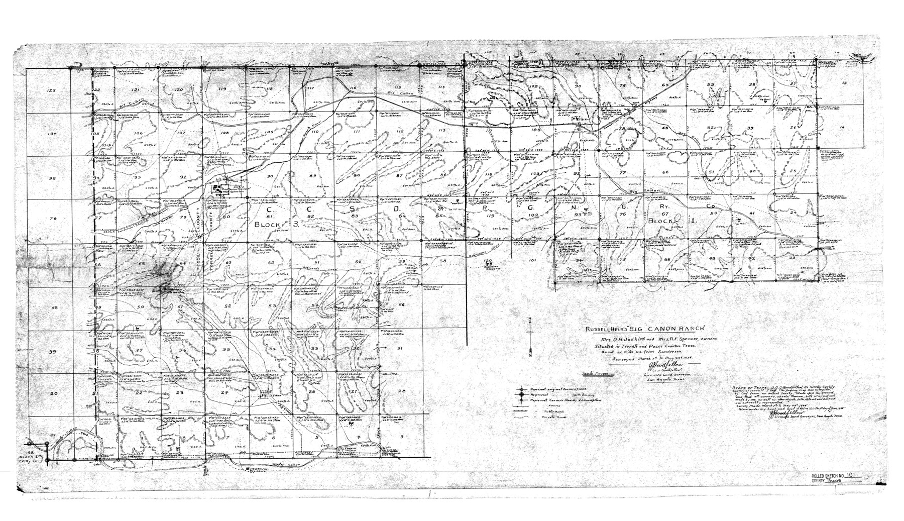
Pecos County Rolled Sketch 101
Russell Heir's "Big Canon Ranch"
-
Map/Doc
7249
-
Collection
General Map Collection
-
Object Dates
1938/5/23 (Survey Date)
1938/7/23 (File Date)
1938/6/9 (Creation Date)
-
People and Organizations
J.J. Goodfellow (Surveyor/Engineer)
-
Counties
Pecos Terrell
-
Subjects
Surveying Rolled Sketch
-
Height x Width
22.5 x 39.0 inches
57.2 x 99.1 cm
-
Scale
1" = 1000 varas
Part of: General Map Collection
Bandera County Working Sketch 22

Print $20.00
- Digital $50.00
Bandera County Working Sketch 22
1949
Size 42.8 x 24.9 inches
Map/Doc 67618
Reeves County Rolled Sketch 20

Print $20.00
- Digital $50.00
Reeves County Rolled Sketch 20
Size 32.1 x 38.4 inches
Map/Doc 9852
Terrell County Sketch File 8

Print $6.00
- Digital $50.00
Terrell County Sketch File 8
Size 11.4 x 10.2 inches
Map/Doc 37902
Flight Mission No. DIX-6P, Frame 118, Aransas County

Print $20.00
- Digital $50.00
Flight Mission No. DIX-6P, Frame 118, Aransas County
1956
Size 19.1 x 22.9 inches
Map/Doc 83824
Concho County Sketch File 37

Print $20.00
- Digital $50.00
Concho County Sketch File 37
1938
Size 18.7 x 29.1 inches
Map/Doc 11162

Bell County Sketch File 19a

Print $4.00
- Digital $50.00
Bell County Sketch File 19a
Size 8.1 x 8.7 inches
Map/Doc 14404
Stonewall County Rolled Sketch 22

Print $20.00
- Digital $50.00
Stonewall County Rolled Sketch 22
1951
Size 33.2 x 30.9 inches
Map/Doc 9961
Briscoe County Sketch File M

Print $40.00
- Digital $50.00
Briscoe County Sketch File M
Size 36.1 x 28.0 inches
Map/Doc 11010
Flight Mission No. DQN-1K, Frame 49, Calhoun County

Print $20.00
- Digital $50.00
Flight Mission No. DQN-1K, Frame 49, Calhoun County
1953
Size 18.6 x 22.4 inches
Map/Doc 84149
Harris County Sketch File D

Print $4.00
- Digital $50.00
Harris County Sketch File D
1860
Size 8.1 x 4.9 inches
Map/Doc 25313
Crane County Rolled Sketch REE

Print $40.00
- Digital $50.00
Crane County Rolled Sketch REE
1936
Size 50.6 x 34.1 inches
Map/Doc 8681
You may also like
Delta County Sketch File 1a

Print $4.00
- Digital $50.00
Delta County Sketch File 1a
Size 8.3 x 8.9 inches
Map/Doc 20668
Bastrop County Sketch File 2

Print $4.00
- Digital $50.00
Bastrop County Sketch File 2
1858
Size 10.8 x 8.3 inches
Map/Doc 14042

Polk County Sketch File 30

Print $18.00
- Digital $50.00
Polk County Sketch File 30
1934
Size 14.1 x 8.5 inches
Map/Doc 34206
Van Zandt County Sketch File 29a

Print $4.00
- Digital $50.00
Van Zandt County Sketch File 29a
1859
Size 14.2 x 6.6 inches
Map/Doc 39455
Brewster County Rolled Sketch 97

Print $20.00
- Digital $50.00
Brewster County Rolled Sketch 97
1952
Size 31.6 x 30.7 inches
Map/Doc 5254
Shelby County Rolled Sketch 21

Print $20.00
- Digital $50.00
Shelby County Rolled Sketch 21
Size 17.0 x 22.3 inches
Map/Doc 93285
Jeff Davis County Working Sketch 22

Print $20.00
- Digital $50.00
Jeff Davis County Working Sketch 22
1957
Size 18.9 x 20.9 inches
Map/Doc 66517
Coast Chart No. 211 - Padre I. and Laguna Madre Lat. 27° 12' to Lat. 26° 33' Texas

Print $20.00
- Digital $50.00
Coast Chart No. 211 - Padre I. and Laguna Madre Lat. 27° 12' to Lat. 26° 33' Texas
1890
Size 27.2 x 18.2 inches
Map/Doc 72821
Rains County Working Sketch Graphic Index

Print $20.00
- Digital $50.00
Rains County Working Sketch Graphic Index
1942
Size 31.3 x 29.5 inches
Map/Doc 76675
Mason County Boundary File 6

Print $28.00
- Digital $50.00
Mason County Boundary File 6
Size 14.3 x 8.9 inches
Map/Doc 56874
Matagorda County Sketch File 31

Print $4.00
- Digital $50.00
Matagorda County Sketch File 31
1919
Size 11.4 x 8.2 inches
Map/Doc 30815