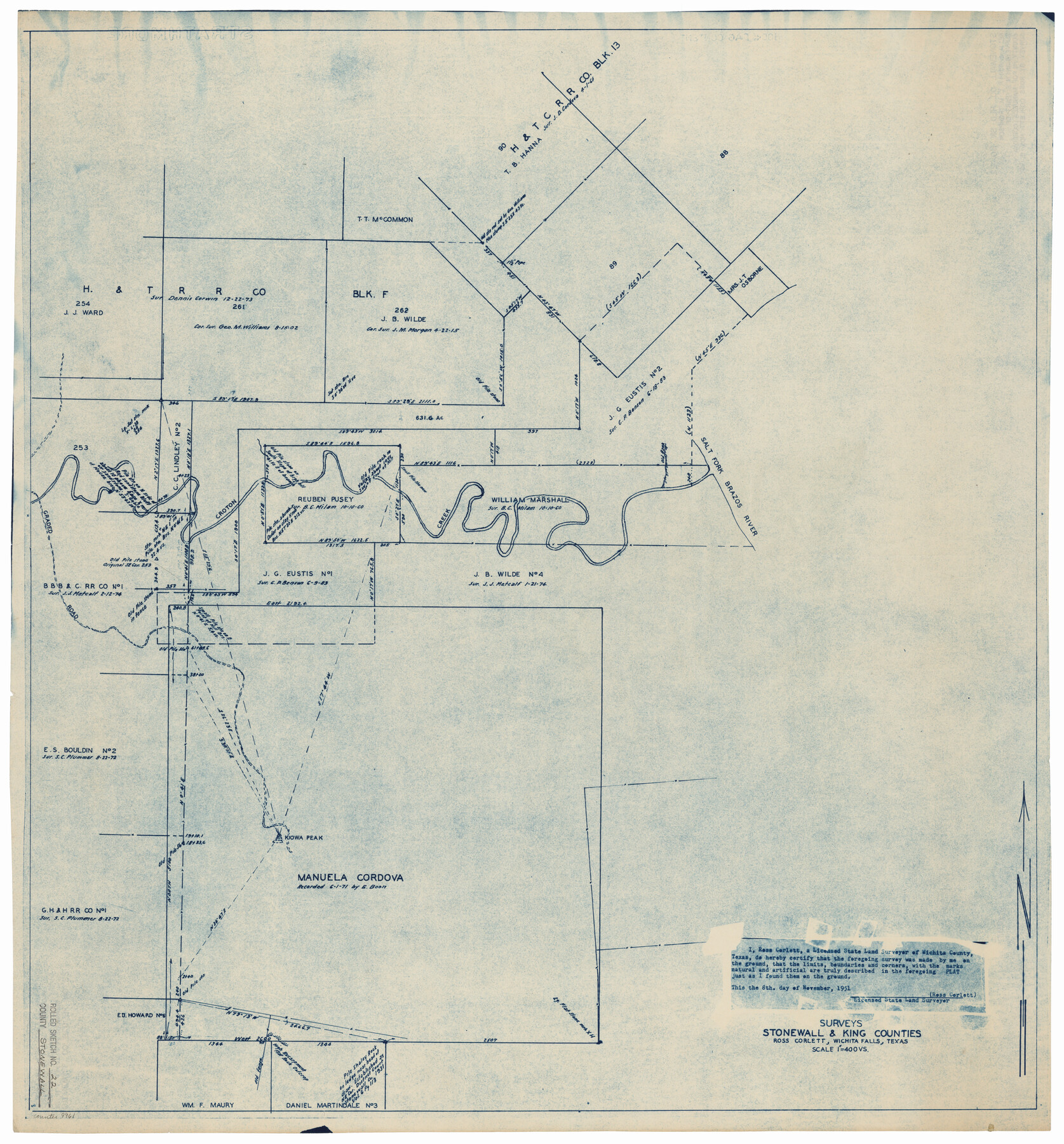
Stonewall County Rolled Sketch 22
Surveys Stonewall & King Counties
-
Map/Doc
9961
-
Collection
General Map Collection
-
Object Dates
1951/11/8 (Creation Date)
1951 (File Date)
-
People and Organizations
Ross Corlett (Surveyor/Engineer)
-
Counties
Stonewall King
-
Subjects
Surveying Rolled Sketch
-
Height x Width
33.2 x 30.9 inches
84.3 x 78.5 cm
-
Medium
blueprint/diazo
-
Scale
1" = 400 varas
Part of: General Map Collection
Upton County Working Sketch 7

Print $20.00
- Digital $50.00
Upton County Working Sketch 7
1912
Size 26.3 x 29.9 inches
Map/Doc 69503
Orange County Sketch File 22

Print $20.00
- Digital $50.00
Orange County Sketch File 22
1910
Size 16.2 x 18.7 inches
Map/Doc 12121
San Luis Pass to East Matagorda Bay

Print $40.00
- Digital $50.00
San Luis Pass to East Matagorda Bay
1986
Size 35.6 x 49.0 inches
Map/Doc 69971
Jefferson County NRC Article 33.136 Location Key Sheet

Print $20.00
- Digital $50.00
Jefferson County NRC Article 33.136 Location Key Sheet
1974
Size 27.0 x 23.0 inches
Map/Doc 77029

Andrews County Rolled Sketch 11A

Print $20.00
- Digital $50.00
Andrews County Rolled Sketch 11A
1933
Size 28.1 x 37.4 inches
Map/Doc 77162
San Patricio County Rolled Sketch 46C

Print $3.00
- Digital $50.00
San Patricio County Rolled Sketch 46C
1983
Size 11.0 x 17.5 inches
Map/Doc 8374

Upton County Rolled Sketch 19

Print $40.00
- Digital $50.00
Upton County Rolled Sketch 19
1933
Size 55.2 x 40.0 inches
Map/Doc 10040
Flight Mission No. DAG-21K, Frame 89, Matagorda County

Print $20.00
- Digital $50.00
Flight Mission No. DAG-21K, Frame 89, Matagorda County
1952
Size 18.5 x 22.3 inches
Map/Doc 86418

Medina County Rolled Sketch 21

Print $20.00
- Digital $50.00
Medina County Rolled Sketch 21
2002
Size 33.5 x 19.1 inches
Map/Doc 76412
You may also like
[H. & G. N. Block 1]
![90939, [H. & G. N. Block 1], Twichell Survey Records](https://historictexasmaps.com/wmedia_w700/maps/90939-1.tif.jpg)
Print $20.00
- Digital $50.00
[H. & G. N. Block 1]
1902
Size 13.5 x 16.4 inches
Map/Doc 90939
Croquis del terro, camino, bosques, barrancas, cerro y beredas de Cerro-gordo con las posiciones de las topas Mejicanas y Americanas con sus respectivos Generales Cuerpos y Baterias el dis 18 de Abril de 1847

Print $20.00
Croquis del terro, camino, bosques, barrancas, cerro y beredas de Cerro-gordo con las posiciones de las topas Mejicanas y Americanas con sus respectivos Generales Cuerpos y Baterias el dis 18 de Abril de 1847
1847
Size 20.1 x 26.0 inches
Map/Doc 97343
United States Atlantic and Gulf Coasts Including Puerto Rico and the Virgin Islands

Print $40.00
- Digital $50.00
United States Atlantic and Gulf Coasts Including Puerto Rico and the Virgin Islands
1973
Size 21.9 x 60.6 inches
Map/Doc 76125
Topographical Map of the Rio Grande, Sheet No. 26

Print $20.00
- Digital $50.00
Topographical Map of the Rio Grande, Sheet No. 26
1912
Map/Doc 89550
Map of Harris County

Print $20.00
- Digital $50.00
Map of Harris County
1893
Size 26.9 x 36.5 inches
Map/Doc 66855
Williamson County Sketch File 18

Print $6.00
- Digital $50.00
Williamson County Sketch File 18
1871
Size 12.8 x 8.1 inches
Map/Doc 40342
Flight Mission No. CGI-4N, Frame 22, Cameron County

Print $20.00
- Digital $50.00
Flight Mission No. CGI-4N, Frame 22, Cameron County
1954
Size 18.5 x 22.3 inches
Map/Doc 84655
Jackson County

Print $40.00
- Digital $50.00
Jackson County
1920
Size 49.5 x 41.8 inches
Map/Doc 66878
General Highway Map. Detail of Cities and Towns in Dallas County, Texas [Dallas and vicinity]
![79435, General Highway Map. Detail of Cities and Towns in Dallas County, Texas [Dallas and vicinity], Texas State Library and Archives](https://historictexasmaps.com/wmedia_w700/maps/79435.tif.jpg)
Print $20.00
General Highway Map. Detail of Cities and Towns in Dallas County, Texas [Dallas and vicinity]
1961
Size 18.2 x 24.6 inches
Map/Doc 79435
Sketch Showing surveys on Harbor Island in Nueces County

Print $20.00
- Digital $50.00
Sketch Showing surveys on Harbor Island in Nueces County
1951
Size 45.7 x 34.6 inches
Map/Doc 1915
Working Sketch on East Line of Fisher County [from Main Elm Fork of Brazos River along county line to Justo Rodriguez Survey 357]
![90918, Working Sketch on East Line of Fisher County [from Main Elm Fork of Brazos River along county line to Justo Rodriguez Survey 357], Twichell Survey Records](https://historictexasmaps.com/wmedia_w700/maps/90918-1.tif.jpg)
Print $20.00
- Digital $50.00
Working Sketch on East Line of Fisher County [from Main Elm Fork of Brazos River along county line to Justo Rodriguez Survey 357]
1901
Size 17.2 x 22.4 inches
Map/Doc 90918