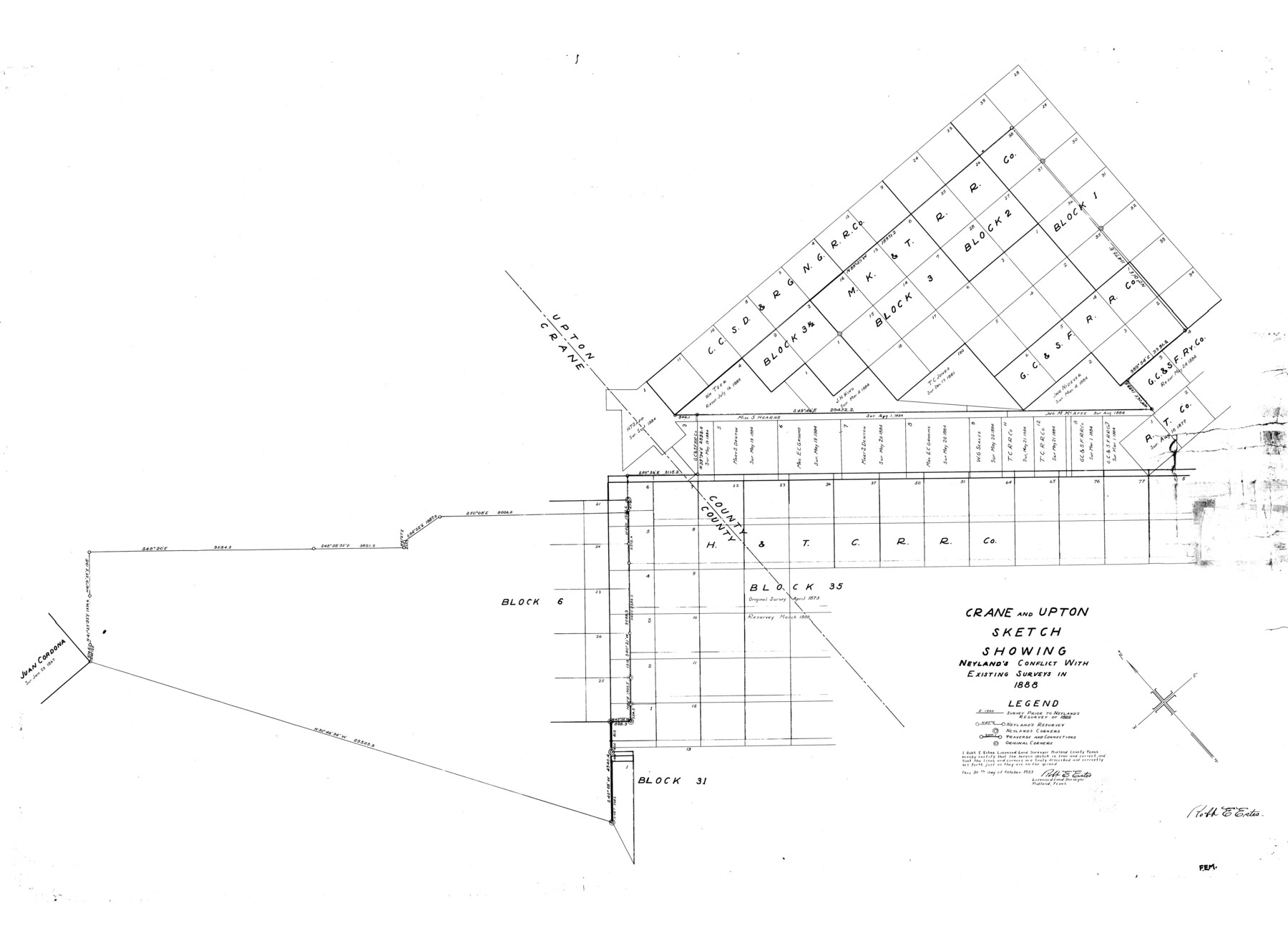
Upton County Rolled Sketch 19
Crane and Upton sketch showing Neyland's conflict with existing surveys in 1888
-
Map/Doc
10040
-
Collection
General Map Collection
-
Object Dates
10/30/1933 (Creation Date)
-
People and Organizations
Robt. E. Estes (Surveyor/Engineer)
-
Counties
Upton Crane
-
Subjects
Surveying Rolled Sketch
-
Height x Width
55.2 x 40.0 inches
140.2 x 101.6 cm
Part of: General Map Collection
Falls County Sketch File 2

Print $4.00
- Digital $50.00
Falls County Sketch File 2
1854
Size 13.1 x 8.3 inches
Map/Doc 22332
Reagan County Sketch File 10

Print $40.00
- Digital $50.00
Reagan County Sketch File 10
1928
Size 13.7 x 14.2 inches
Map/Doc 34989
Kerr County Rolled Sketch 14

Print $20.00
- Digital $50.00
Kerr County Rolled Sketch 14
1951
Size 38.3 x 30.6 inches
Map/Doc 9345
Montgomery County Sketch File 31

Print $20.00
- Digital $50.00
Montgomery County Sketch File 31
1932
Size 35.2 x 34.1 inches
Map/Doc 10550
St. Louis, Brownsville & Mexico Railway Location Map from Mile 0 to Mile 20

Print $40.00
- Digital $50.00
St. Louis, Brownsville & Mexico Railway Location Map from Mile 0 to Mile 20
1906
Size 19.5 x 74.5 inches
Map/Doc 64075
Randall County Sketch File 2

Print $4.00
- Digital $50.00
Randall County Sketch File 2
1913
Size 7.3 x 8.8 inches
Map/Doc 34961
[Map to illustrate possible mineral resources on the lands belonging to the University of Texas]
![62963, [Map to illustrate possible mineral resources on the lands belonging to the University of Texas], General Map Collection](https://historictexasmaps.com/wmedia_w700/maps/62963.tif.jpg)
Print $2.00
- Digital $50.00
[Map to illustrate possible mineral resources on the lands belonging to the University of Texas]
Size 10.2 x 7.7 inches
Map/Doc 62963
Irion County Boundary File 4

Print $23.00
- Digital $50.00
Irion County Boundary File 4
Size 11.2 x 8.8 inches
Map/Doc 55350
Fayette County Working Sketch 10

Print $20.00
- Digital $50.00
Fayette County Working Sketch 10
1985
Size 27.1 x 38.5 inches
Map/Doc 69174
Crane County Rolled Sketch 19

Print $20.00
- Digital $50.00
Crane County Rolled Sketch 19
1926
Size 26.4 x 28.3 inches
Map/Doc 5577
Motley County Sketch File 18 (S)

Print $28.00
- Digital $50.00
Motley County Sketch File 18 (S)
1902
Size 13.0 x 8.0 inches
Map/Doc 32192
Plan of the City of Galveston, Texas

Print $20.00
- Digital $50.00
Plan of the City of Galveston, Texas
1845
Size 19.3 x 41.8 inches
Map/Doc 4665
You may also like
Cameron County Rolled Sketch 22

Print $63.00
- Digital $50.00
Cameron County Rolled Sketch 22
Size 9.8 x 15.0 inches
Map/Doc 43919
Map of Wilson County

Print $20.00
- Digital $50.00
Map of Wilson County
1879
Size 23.0 x 24.4 inches
Map/Doc 4157
Bexar County Working Sketch 7

Print $20.00
- Digital $50.00
Bexar County Working Sketch 7
1947
Size 21.8 x 37.6 inches
Map/Doc 67323
Map of the Houston & Great Northern Railroad

Print $40.00
- Digital $50.00
Map of the Houston & Great Northern Railroad
1871
Size 26.2 x 87.5 inches
Map/Doc 64471
Uvalde County Working Sketch 1

Print $20.00
- Digital $50.00
Uvalde County Working Sketch 1
1911
Size 27.3 x 21.0 inches
Map/Doc 72071
[Surveying Sketch of Loma Blanca, Santa Rosa, San Antonio del Encinal, et al]
![4449, [Surveying Sketch of Loma Blanca, Santa Rosa, San Antonio del Encinal, et al], Maddox Collection](https://historictexasmaps.com/wmedia_w700/maps/4449.tif.jpg)
Print $20.00
- Digital $50.00
[Surveying Sketch of Loma Blanca, Santa Rosa, San Antonio del Encinal, et al]
Size 19.0 x 22.1 inches
Map/Doc 4449
Culberson County Working Sketch 14

Print $20.00
- Digital $50.00
Culberson County Working Sketch 14
1923
Size 17.9 x 19.2 inches
Map/Doc 68466
Fannin County Rolled Sketch 18F

Print $2.00
- Digital $50.00
Fannin County Rolled Sketch 18F
Size 8.9 x 8.2 inches
Map/Doc 5873
Map of Harrison County

Print $20.00
- Digital $50.00
Map of Harrison County
1911
Size 43.8 x 39.8 inches
Map/Doc 4698
[Sketch showing unsurveyed land in West Texas as of 1902]
![89937, [Sketch showing unsurveyed land in West Texas as of 1902], Twichell Survey Records](https://historictexasmaps.com/wmedia_w700/maps/89937-1.tif.jpg)
Print $20.00
- Digital $50.00
[Sketch showing unsurveyed land in West Texas as of 1902]
Size 42.0 x 34.0 inches
Map/Doc 89937
Baylor County Sketch File Z4

Print $2.00
- Digital $50.00
Baylor County Sketch File Z4
1898
Size 9.3 x 7.2 inches
Map/Doc 14114
[E. L. & R. R. RR. Co. Block B9 and other surveys along Yellow House Creek]
![90872, [E. L. & R. R. RR. Co. Block B9 and other surveys along Yellow House Creek], Twichell Survey Records](https://historictexasmaps.com/wmedia_w700/maps/90872-2.tif.jpg)
Print $3.00
- Digital $50.00
[E. L. & R. R. RR. Co. Block B9 and other surveys along Yellow House Creek]
Size 16.4 x 11.7 inches
Map/Doc 90872