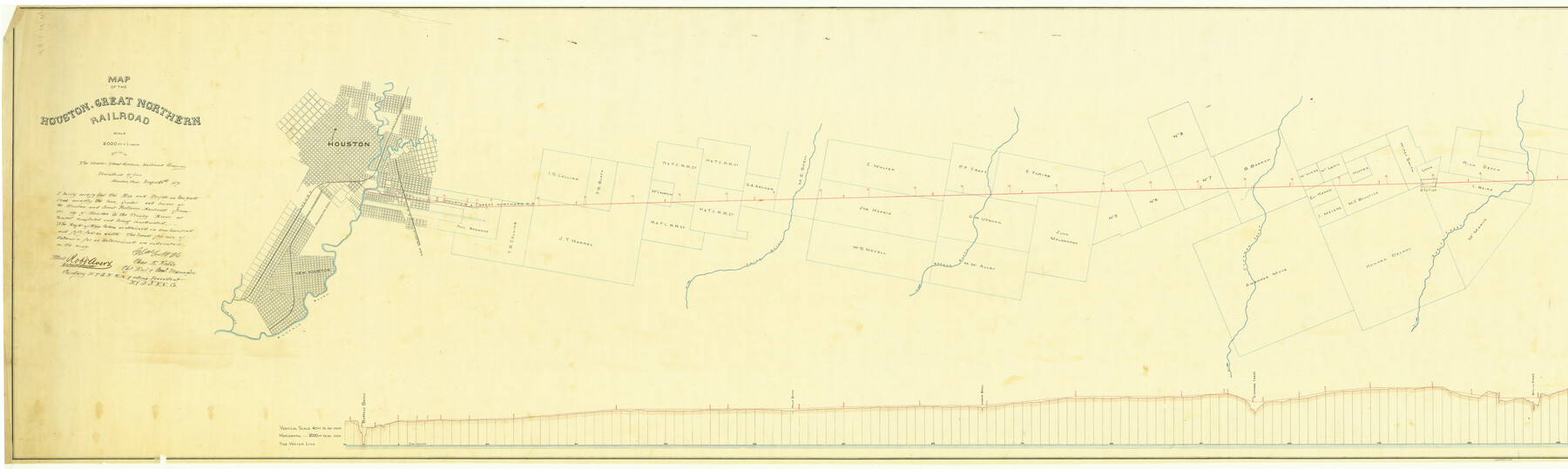
Map of the Houston & Great Northern Railroad
Z-2-133
-
Map/Doc
64471
-
Collection
General Map Collection
-
Object Dates
1871/8/18 (Creation Date)
1871/9/15 (File Date)
-
Counties
Harris
-
Subjects
Railroads
-
Height x Width
26.2 x 87.5 inches
66.5 x 222.3 cm
-
Medium
paper, manuscript
-
Scale
2000 ft = 1 inch
-
Comments
From Houston to the Trinity River. Segment 1; see counter no. 64472 for segment 2.
-
Features
H&GN
Houston
H&TC
GH&H
Harrisburg Road
New Orleans R. R.
New Houston
Buffalo Bayou
Brays Bayou
White Oak Bayou
Halls Bayou
Greens Bayou
Cypress Creek
Spring Creek
Part of: General Map Collection
San Augustine County Working Sketch 1

Print $3.00
- Digital $50.00
San Augustine County Working Sketch 1
1906
Size 9.1 x 11.3 inches
Map/Doc 63688
Fayette County Boundary File 7

Print $40.00
- Digital $50.00
Fayette County Boundary File 7
Size 18.1 x 13.1 inches
Map/Doc 53400
Flight Mission No. DCL-6C, Frame 132, Kenedy County

Print $20.00
- Digital $50.00
Flight Mission No. DCL-6C, Frame 132, Kenedy County
1943
Size 18.6 x 22.3 inches
Map/Doc 85962
Galveston County Rolled Sketch 14

Print $155.00
- Digital $50.00
Galveston County Rolled Sketch 14
1950
Size 10.1 x 15.3 inches
Map/Doc 44808
[Drawings of individual counties for Pressler and Langermann's 1879 Map of Texas]
![[Drawings of individual counties for Pressler and Langermann's 1879 Map of Texas]](https://historictexasmaps.com/wmedia_w700/maps/4864.tif.jpg)
Print $20.00
- Digital $50.00
[Drawings of individual counties for Pressler and Langermann's 1879 Map of Texas]
1878
Size 38.3 x 26.8 inches
Map/Doc 4864
Armstrong County Sketch File 7

Print $6.00
- Digital $50.00
Armstrong County Sketch File 7
1902
Size 11.1 x 8.6 inches
Map/Doc 13702
Shelby County Sketch File 4

Print $4.00
- Digital $50.00
Shelby County Sketch File 4
1852
Size 13.1 x 8.2 inches
Map/Doc 36597
Crockett County Rolled Sketch 92

Print $20.00
- Digital $50.00
Crockett County Rolled Sketch 92
1977
Size 43.0 x 25.2 inches
Map/Doc 5632
Controlled Mosaic by Jack Amman Photogrammetric Engineers, Inc - Sheet 47

Print $20.00
- Digital $50.00
Controlled Mosaic by Jack Amman Photogrammetric Engineers, Inc - Sheet 47
1954
Size 20.0 x 24.0 inches
Map/Doc 83506
[Plat of Location and Right of Way from El Paso, Tex. To New Mexico Line, Rio Grande and El Paso R. R.]
![64084, [Plat of Location and Right of Way from El Paso, Tex. To New Mexico Line, Rio Grande and El Paso R. R.], General Map Collection](https://historictexasmaps.com/wmedia_w700/maps/64084.tif.jpg)
Print $20.00
- Digital $50.00
[Plat of Location and Right of Way from El Paso, Tex. To New Mexico Line, Rio Grande and El Paso R. R.]
Size 22.7 x 46.8 inches
Map/Doc 64084
Tom Green County Rolled Sketch 12

Print $40.00
- Digital $50.00
Tom Green County Rolled Sketch 12
1951
Size 51.0 x 42.5 inches
Map/Doc 10000
Lynn County Boundary File 6a

Print $2.00
- Digital $50.00
Lynn County Boundary File 6a
Size 11.2 x 8.7 inches
Map/Doc 56641
You may also like
[El Javali Grant,] Sketch of 2560 acres of land in Starr County
![474, [El Javali Grant,] Sketch of 2560 acres of land in Starr County, Maddox Collection](https://historictexasmaps.com/wmedia_w700/maps/0474-1.tif.jpg)
Print $20.00
- Digital $50.00
[El Javali Grant,] Sketch of 2560 acres of land in Starr County
Size 13.4 x 14.0 inches
Map/Doc 474
McMullen County Rolled Sketch 9

Print $20.00
- Digital $50.00
McMullen County Rolled Sketch 9
Size 34.4 x 40.9 inches
Map/Doc 6726
Irion County Working Sketch 8

Print $20.00
- Digital $50.00
Irion County Working Sketch 8
1937
Size 42.0 x 41.0 inches
Map/Doc 66417
Crockett County Rolled Sketch 16

Print $20.00
- Digital $50.00
Crockett County Rolled Sketch 16
1880
Size 36.2 x 26.2 inches
Map/Doc 5581
A New Map of Nebraska, Kansas, New Mexico and Indian Territories

Print $20.00
- Digital $50.00
A New Map of Nebraska, Kansas, New Mexico and Indian Territories
Size 18.6 x 15.2 inches
Map/Doc 93985
Menard County Sketch File 28

Print $8.00
- Digital $50.00
Menard County Sketch File 28
1955
Size 11.0 x 8.6 inches
Map/Doc 31567
[Map to illustrate possible mineral resources on the lands belonging to the University of Texas]
![62963, [Map to illustrate possible mineral resources on the lands belonging to the University of Texas], General Map Collection](https://historictexasmaps.com/wmedia_w700/maps/62963.tif.jpg)
Print $2.00
- Digital $50.00
[Map to illustrate possible mineral resources on the lands belonging to the University of Texas]
Size 10.2 x 7.7 inches
Map/Doc 62963
Flight Mission No. BRA-7M, Frame 36, Jefferson County

Print $20.00
- Digital $50.00
Flight Mission No. BRA-7M, Frame 36, Jefferson County
1953
Size 18.7 x 22.3 inches
Map/Doc 85487
Upton County Working Sketch 56

Print $20.00
- Digital $50.00
Upton County Working Sketch 56
1985
Size 43.9 x 43.8 inches
Map/Doc 69553
Jackson County

Print $20.00
- Digital $50.00
Jackson County
1920
Size 46.9 x 40.1 inches
Map/Doc 95541

Stonewall County Rolled Sketch 24B

Print $40.00
- Digital $50.00
Stonewall County Rolled Sketch 24B
1954
Size 50.1 x 43.1 inches
Map/Doc 9964