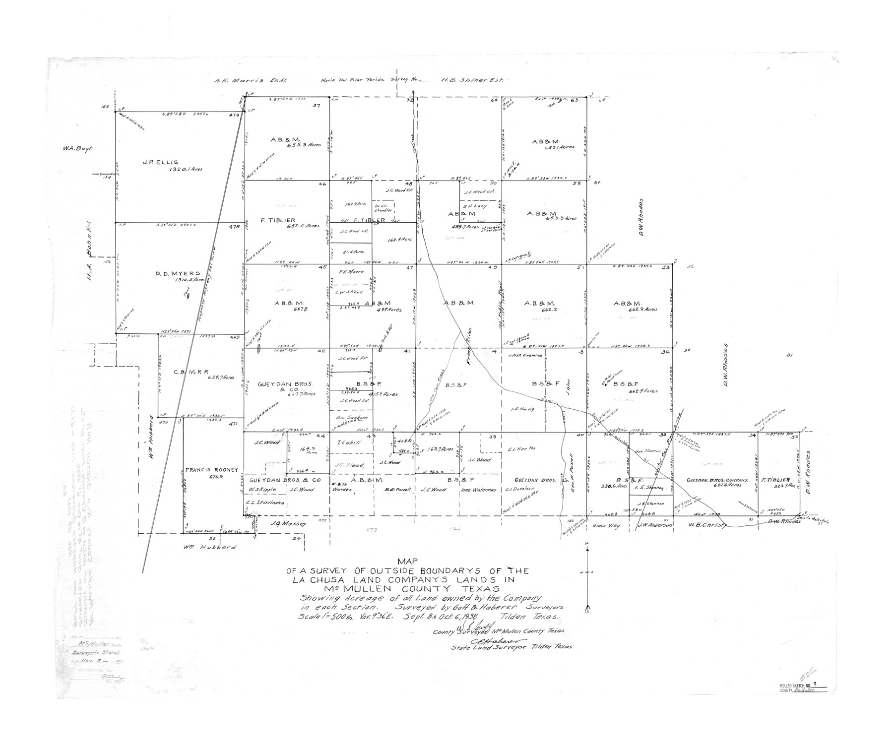
McMullen County Rolled Sketch 9
Map of a survey of outside boundarys of the La Chusa Land Company's lands in McMullen County, Texas showing acreage of all land owned by the Company in each section
-
Map/Doc
6726
-
Collection
General Map Collection
-
Object Dates
1938/10/6 (Survey Date)
1941/11/3 (File Date)
-
People and Organizations
C.E. Haberer (Surveyor/Engineer)
W.S. Goff (Surveyor/Engineer)
-
Counties
McMullen
-
Subjects
Surveying Rolled Sketch
-
Height x Width
34.4 x 40.9 inches
87.4 x 103.9 cm
-
Scale
1" = 500 varas
Part of: General Map Collection
[Sketch of Surveys on Big Sandy Creek]
![179, [Sketch of Surveys on Big Sandy Creek], General Map Collection](https://historictexasmaps.com/wmedia_w700/maps/179.tif.jpg)
Print $2.00
- Digital $50.00
[Sketch of Surveys on Big Sandy Creek]
1841
Size 8.2 x 9.2 inches
Map/Doc 179
Trinity River, Five Mile Creek Sheet

Print $20.00
- Digital $50.00
Trinity River, Five Mile Creek Sheet
1923
Size 20.0 x 40.4 inches
Map/Doc 65197
Culberson County Rolled Sketch 31A

Print $20.00
- Digital $50.00
Culberson County Rolled Sketch 31A
Size 43.4 x 35.6 inches
Map/Doc 8748
Bell County Working Sketch 8

Print $20.00
- Digital $50.00
Bell County Working Sketch 8
1954
Size 44.2 x 37.3 inches
Map/Doc 67348
Oldham County Working Sketch 9

Print $20.00
- Digital $50.00
Oldham County Working Sketch 9
1982
Size 33.3 x 37.2 inches
Map/Doc 71331
Hidalgo County Working Sketch 1

Print $20.00
- Digital $50.00
Hidalgo County Working Sketch 1
1939
Size 24.8 x 21.4 inches
Map/Doc 66178
Presidio County Sketch File 102

Print $4.00
- Digital $50.00
Presidio County Sketch File 102
Size 11.3 x 8.8 inches
Map/Doc 34793
Map of Blanco County

Print $20.00
- Digital $50.00
Map of Blanco County
1862
Size 28.1 x 18.7 inches
Map/Doc 3303
San Patricio County Working Sketch 9

Print $40.00
- Digital $50.00
San Patricio County Working Sketch 9
1937
Size 52.8 x 44.0 inches
Map/Doc 63771
Brewster County Working Sketch 54

Print $20.00
- Digital $50.00
Brewster County Working Sketch 54
1952
Size 23.7 x 37.0 inches
Map/Doc 67655
Montague County Working Sketch 11

Print $20.00
- Digital $50.00
Montague County Working Sketch 11
1936
Size 33.8 x 21.3 inches
Map/Doc 71077
Flight Mission No. DIX-5P, Frame 150, Aransas County

Print $20.00
- Digital $50.00
Flight Mission No. DIX-5P, Frame 150, Aransas County
1956
Size 17.8 x 18.3 inches
Map/Doc 83812
You may also like
Fractional Township No. 7 South Range No. 15 East of the Indian Meridian, Indian Territory

Print $20.00
- Digital $50.00
Fractional Township No. 7 South Range No. 15 East of the Indian Meridian, Indian Territory
1896
Size 19.2 x 24.3 inches
Map/Doc 75226
[Galveston, Harrisburg & San Antonio Railroad from Cuero to Stockdale]
![64191, [Galveston, Harrisburg & San Antonio Railroad from Cuero to Stockdale], General Map Collection](https://historictexasmaps.com/wmedia_w700/maps/64191.tif.jpg)
Print $20.00
- Digital $50.00
[Galveston, Harrisburg & San Antonio Railroad from Cuero to Stockdale]
1907
Size 14.2 x 34.2 inches
Map/Doc 64191
Texas City Channel, Texas, Channel and Turning Basin Dredging - Sheet 1

Print $20.00
- Digital $50.00
Texas City Channel, Texas, Channel and Turning Basin Dredging - Sheet 1
1958
Size 29.3 x 40.8 inches
Map/Doc 61831

Galveston County Rolled Sketch 17

Print $20.00
- Digital $50.00
Galveston County Rolled Sketch 17
1940
Size 40.4 x 35.4 inches
Map/Doc 9079
Pecos County Working Sketch 34

Print $20.00
- Digital $50.00
Pecos County Working Sketch 34
1939
Size 32.7 x 27.6 inches
Map/Doc 71506
Webb County Working Sketch 83

Print $20.00
- Digital $50.00
Webb County Working Sketch 83
1980
Size 20.7 x 34.9 inches
Map/Doc 72450
[Northwest Garza County around John Walker and Thomas Hughes surveys]
![90849, [Northwest Garza County around John Walker and Thomas Hughes surveys], Twichell Survey Records](https://historictexasmaps.com/wmedia_w700/maps/90849-2.tif.jpg)
Print $20.00
- Digital $50.00
[Northwest Garza County around John Walker and Thomas Hughes surveys]
1913
Size 27.5 x 14.5 inches
Map/Doc 90849
Cameron County Rolled Sketch 30

Print $20.00
- Digital $50.00
Cameron County Rolled Sketch 30
1930
Size 36.3 x 24.4 inches
Map/Doc 5394
Jefferson County Working Sketch 1

Print $20.00
- Digital $50.00
Jefferson County Working Sketch 1
Size 22.7 x 17.5 inches
Map/Doc 66544
[Leagues 319-325]
![91360, [Leagues 319-325], Twichell Survey Records](https://historictexasmaps.com/wmedia_w700/maps/91360-1.tif.jpg)
Print $20.00
- Digital $50.00
[Leagues 319-325]
Size 37.3 x 22.9 inches
Map/Doc 91360
Map of Harrison County, Texas

Print $20.00
- Digital $50.00
Map of Harrison County, Texas
1879
Size 20.2 x 21.9 inches
Map/Doc 375