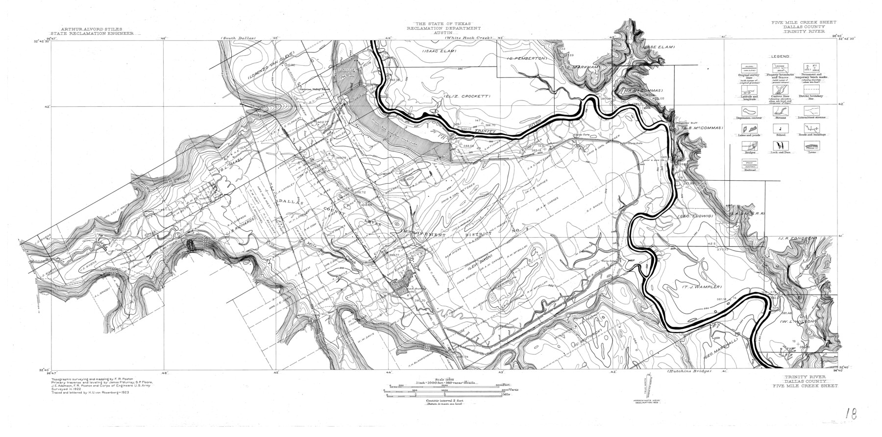
Trinity River, Five Mile Creek Sheet
-
Map/Doc
65197
-
Collection
General Map Collection
-
Object Dates
1923 (Creation Date)
-
People and Organizations
Texas State Reclamation Department (Publisher)
H.U. von Rosenberg (Draftsman)
H.U. von Rosenberg (Compiler)
J.P. Murray (Surveyor/Engineer)
S.P. Floore (Surveyor/Engineer)
J.E. Adamson (Surveyor/Engineer)
F.R. Poston (Surveyor/Engineer)
-
Counties
Dallas
-
Subjects
River Surveys Topographic
-
Height x Width
20.0 x 40.4 inches
50.8 x 102.6 cm
-
Comments
Five Mile Creek Sheet located south of the White Rock Creek Sheet and north of the Hutchins Bridge Sheet.
Part of: General Map Collection
Bastrop County Working Sketch 8

Print $20.00
- Digital $50.00
Bastrop County Working Sketch 8
1937
Size 23.9 x 43.1 inches
Map/Doc 67308
Taylor County Rolled Sketch 20

Print $20.00
- Digital $50.00
Taylor County Rolled Sketch 20
Size 25.6 x 33.9 inches
Map/Doc 7914
Flight Mission No. CUG-3P, Frame 169, Kleberg County

Print $20.00
- Digital $50.00
Flight Mission No. CUG-3P, Frame 169, Kleberg County
1956
Size 18.5 x 22.2 inches
Map/Doc 86289
Zavala County Rolled Sketch 16

Print $20.00
- Digital $50.00
Zavala County Rolled Sketch 16
Size 19.4 x 25.4 inches
Map/Doc 8321
Foard County Sketch File 9

Print $20.00
- Digital $50.00
Foard County Sketch File 9
1882
Size 19.7 x 17.1 inches
Map/Doc 11492
Flight Mission No. DQN-2K, Frame 123, Calhoun County

Print $20.00
- Digital $50.00
Flight Mission No. DQN-2K, Frame 123, Calhoun County
1953
Size 16.6 x 16.5 inches
Map/Doc 84299
Harris County Working Sketch 26

Print $20.00
- Digital $50.00
Harris County Working Sketch 26
1930
Size 23.9 x 27.2 inches
Map/Doc 65918
Houston County Sketch File 37

Print $6.00
- Digital $50.00
Houston County Sketch File 37
1846
Size 12.8 x 7.8 inches
Map/Doc 26819
Jackson County

Print $20.00
- Digital $50.00
Jackson County
1920
Size 46.9 x 40.8 inches
Map/Doc 77324
Lavaca County Sketch File 1

Print $4.00
- Digital $50.00
Lavaca County Sketch File 1
1848
Size 12.7 x 8.2 inches
Map/Doc 29628
Gregg County Boundary File 5

Print $4.00
- Digital $50.00
Gregg County Boundary File 5
Size 13.5 x 8.7 inches
Map/Doc 53999
Crockett County Sketch File 4

Print $6.00
- Digital $50.00
Crockett County Sketch File 4
Size 6.4 x 5.2 inches
Map/Doc 19649
You may also like
Liberty County Sketch File 9

Print $8.00
- Digital $50.00
Liberty County Sketch File 9
1857
Size 8.0 x 8.1 inches
Map/Doc 29900
Erath County Working Sketch 23

Print $20.00
- Digital $50.00
Erath County Working Sketch 23
1966
Size 38.2 x 29.0 inches
Map/Doc 69104
Palo Pinto County Working Sketch 10

Print $20.00
- Digital $50.00
Palo Pinto County Working Sketch 10
Size 12.5 x 17.4 inches
Map/Doc 71393
Montague County Working Sketch 27

Print $20.00
- Digital $50.00
Montague County Working Sketch 27
1956
Size 35.8 x 24.9 inches
Map/Doc 71093
[Leagues 622, 621]
![92170, [Leagues 622, 621], Twichell Survey Records](https://historictexasmaps.com/wmedia_w700/maps/92170-1.tif.jpg)
Print $20.00
- Digital $50.00
[Leagues 622, 621]
Size 24.2 x 19.8 inches
Map/Doc 92170
Irion County Rolled Sketch 12

Print $40.00
- Digital $50.00
Irion County Rolled Sketch 12
1945
Size 37.5 x 51.9 inches
Map/Doc 75943
Smith County, Texas

Print $20.00
- Digital $50.00
Smith County, Texas
1880
Size 23.7 x 29.2 inches
Map/Doc 618
J No. 4 - Reconnaissance of Catalina Harbor And the Anchorage on the N.E. Side of the Island, California

Print $20.00
- Digital $50.00
J No. 4 - Reconnaissance of Catalina Harbor And the Anchorage on the N.E. Side of the Island, California
1852
Size 18.3 x 13.1 inches
Map/Doc 97231
Roberts County Working Sketch 2

Print $20.00
- Digital $50.00
Roberts County Working Sketch 2
1939
Size 10.8 x 17.7 inches
Map/Doc 63528
Concho County Sketch File 4

Print $2.00
- Digital $50.00
Concho County Sketch File 4
1858
Size 8.0 x 10.1 inches
Map/Doc 82523
Flight Mission No. CUG-2P, Frame 61, Kleberg County

Print $20.00
- Digital $50.00
Flight Mission No. CUG-2P, Frame 61, Kleberg County
1956
Size 18.5 x 22.2 inches
Map/Doc 86198
Kimble County Sketch File A1

Print $4.00
- Digital $50.00
Kimble County Sketch File A1
Size 8.8 x 13.4 inches
Map/Doc 28961