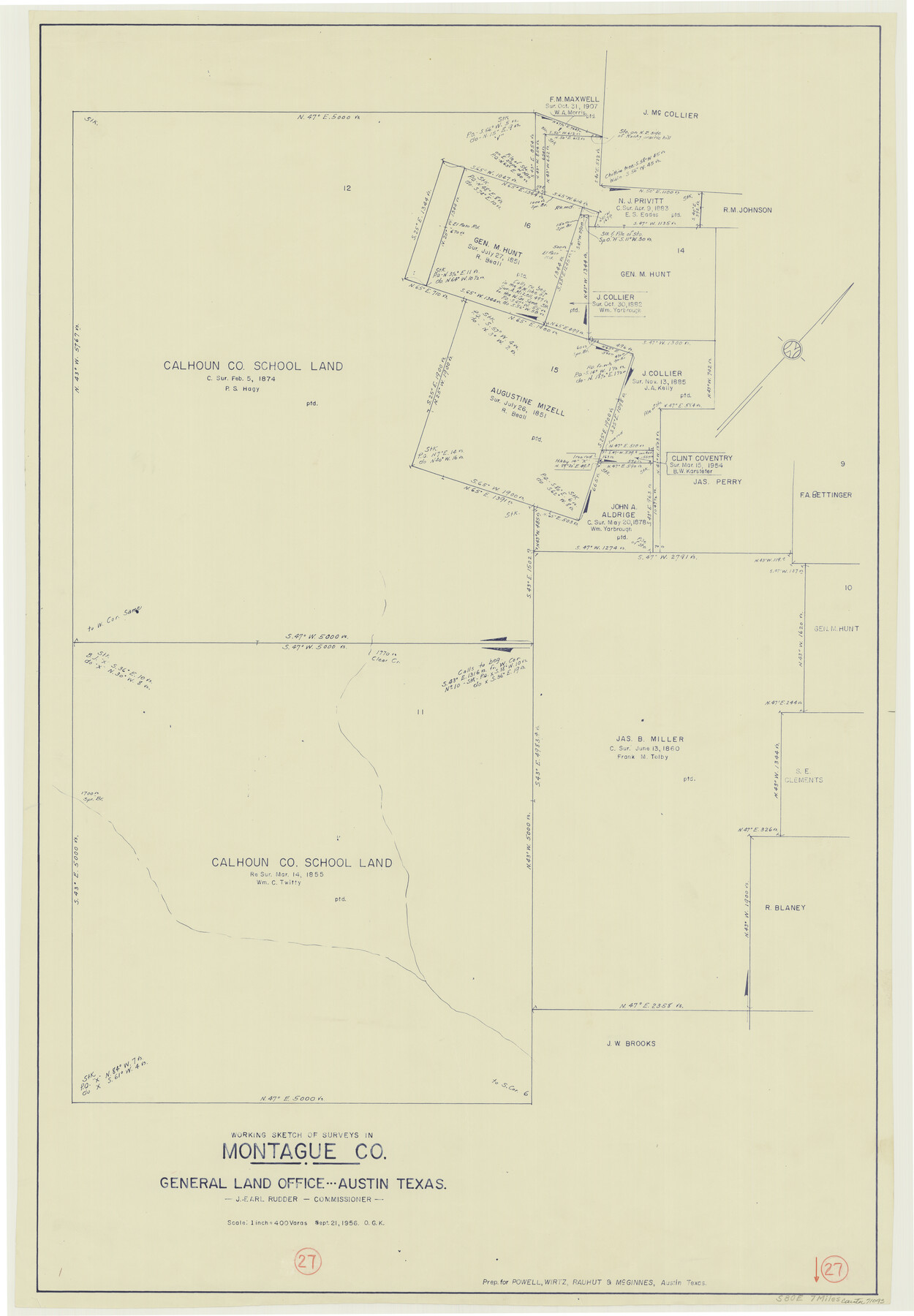
Montague County Working Sketch 27
-
Map/Doc
71093
-
Collection
General Map Collection
-
Object Dates
9/21/1956 (Creation Date)
-
People and Organizations
Otto G. Kurio (Draftsman)
-
Counties
Montague
-
Subjects
Surveying Working Sketch
-
Height x Width
35.8 x 24.9 inches
90.9 x 63.3 cm
-
Scale
1" = 400 varas
Part of: General Map Collection
San Augustine County Working Sketch 12

Print $20.00
- Digital $50.00
San Augustine County Working Sketch 12
1951
Size 29.0 x 21.0 inches
Map/Doc 63700
Howard County Rolled Sketch 2

Print $20.00
- Digital $50.00
Howard County Rolled Sketch 2
1905
Size 27.6 x 23.0 inches
Map/Doc 6232
Flight Mission No. BRA-6M, Frame 95, Jefferson County

Print $20.00
- Digital $50.00
Flight Mission No. BRA-6M, Frame 95, Jefferson County
1953
Size 18.5 x 22.2 inches
Map/Doc 85438
Kinney County Working Sketch 58

Print $20.00
- Digital $50.00
Kinney County Working Sketch 58
1996
Size 36.1 x 31.7 inches
Map/Doc 70240
Foard County Sketch File 11

Print $4.00
- Digital $50.00
Foard County Sketch File 11
Size 7.7 x 10.5 inches
Map/Doc 22812
University Land in Grayson County in Two Parts

Print $20.00
- Digital $50.00
University Land in Grayson County in Two Parts
Size 30.6 x 25.8 inches
Map/Doc 62965
Triangulation Net of the United States

Print $20.00
- Digital $50.00
Triangulation Net of the United States
1938
Size 28.1 x 42.2 inches
Map/Doc 3117
Briscoe County Rolled Sketch 11A

Print $20.00
- Digital $50.00
Briscoe County Rolled Sketch 11A
1913
Size 11.7 x 12.3 inches
Map/Doc 5329
Crockett County Working Sketch 53

Print $20.00
- Digital $50.00
Crockett County Working Sketch 53
1948
Size 24.2 x 27.7 inches
Map/Doc 68386
Atascosa County Rolled Sketch 22

Print $40.00
- Digital $50.00
Atascosa County Rolled Sketch 22
1917
Size 26.3 x 57.2 inches
Map/Doc 8434
Pecos County Sketch File 112

Print $16.00
- Digital $50.00
Pecos County Sketch File 112
1892
Size 11.2 x 8.6 inches
Map/Doc 34061
Leon County Sketch File 8

Print $4.00
- Digital $50.00
Leon County Sketch File 8
1862
Size 12.8 x 8.3 inches
Map/Doc 29724
You may also like
Zavala County Rolled Sketch 24

Print $20.00
- Digital $50.00
Zavala County Rolled Sketch 24
1945
Size 21.7 x 18.2 inches
Map/Doc 8327
Coryell County Working Sketch 23

Print $20.00
- Digital $50.00
Coryell County Working Sketch 23
1977
Size 27.6 x 30.6 inches
Map/Doc 68230
Hutchinson County Working Sketch 17

Print $20.00
- Digital $50.00
Hutchinson County Working Sketch 17
Size 45.8 x 44.2 inches
Map/Doc 66376
Gonzales County Boundary File 2a

Print $8.00
- Digital $50.00
Gonzales County Boundary File 2a
Size 14.4 x 8.9 inches
Map/Doc 53832
Crockett County Rolled Sketch 71

Print $40.00
- Digital $50.00
Crockett County Rolled Sketch 71
1949
Size 54.5 x 38.9 inches
Map/Doc 8722
Edwards County Working Sketch 103

Print $20.00
- Digital $50.00
Edwards County Working Sketch 103
1972
Size 25.6 x 44.3 inches
Map/Doc 68979
Matagorda County

Print $40.00
- Digital $50.00
Matagorda County
1920
Size 41.6 x 49.7 inches
Map/Doc 95582
Revised Sectional Map No. 4 showing land surveys in the western portion of the county of El Paso, Texas

Print $20.00
- Digital $50.00
Revised Sectional Map No. 4 showing land surveys in the western portion of the county of El Paso, Texas
Size 19.0 x 24.2 inches
Map/Doc 4477
Goliad County Sketch File 6

Print $2.00
- Digital $50.00
Goliad County Sketch File 6
1857
Size 8.8 x 4.9 inches
Map/Doc 24220
Val Verde County Sketch File 27

Print $40.00
- Digital $50.00
Val Verde County Sketch File 27
Size 8.7 x 19.4 inches
Map/Doc 39234
Map of the Texas and Pacific Railway and connections

Print $20.00
- Digital $50.00
Map of the Texas and Pacific Railway and connections
1925
Size 8.2 x 9.3 inches
Map/Doc 95772
Roberts County School Lands, Bailey County, Texas

Print $2.00
- Digital $50.00
Roberts County School Lands, Bailey County, Texas
1918
Size 8.8 x 11.3 inches
Map/Doc 90199