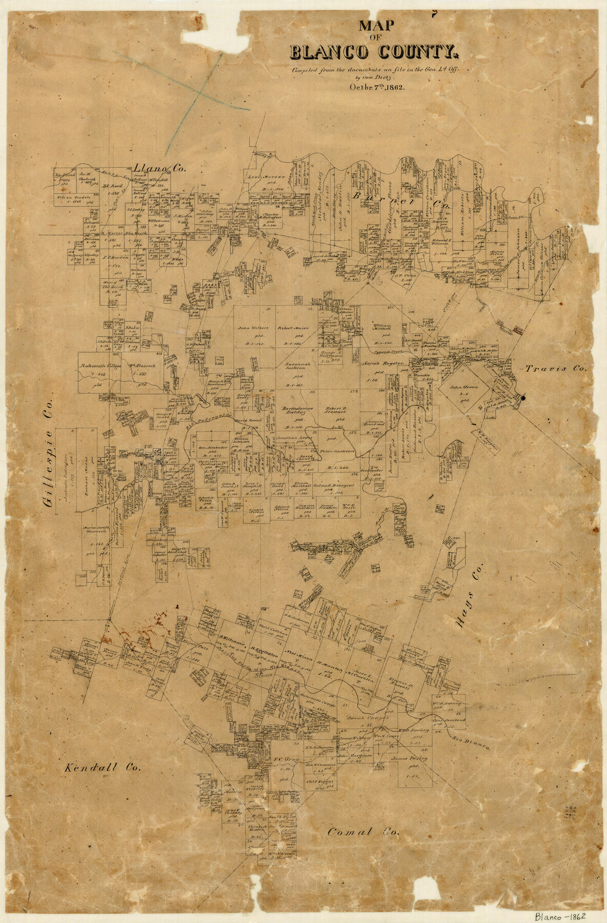
Map of Blanco County
-
Map/Doc
3303
-
Collection
General Map Collection
-
Object Dates
10/7/1862 (Creation Date)
-
People and Organizations
Osw. Dietz (Draftsman)
-
Counties
Blanco
-
Subjects
County
-
Height x Width
28.1 x 18.7 inches
71.4 x 47.5 cm
-
Features
Deep Creek
Rio Blanco
Webb's Creek
Blanco
Martin's Fork of the Rio Blanco
William's Creek
Miller's Creek
Grape Creek
Rio Pedernales
Cypress Creek
Sandy Creek
Little Cypress Creek
Comanche Creek
Pot Creek
Slick Rock Creek
Horseshoe Creek
Double Horn Creek
Love Creek
Pecan Creek
Coal Creek
Part of: General Map Collection
Polk County Working Sketch 11

Print $20.00
- Digital $50.00
Polk County Working Sketch 11
1940
Size 29.3 x 28.6 inches
Map/Doc 71626
Burleson County Working Sketch 18

Print $20.00
- Digital $50.00
Burleson County Working Sketch 18
1980
Size 17.6 x 7.8 inches
Map/Doc 67737
Galveston County Rolled Sketch 4

Print $20.00
- Digital $50.00
Galveston County Rolled Sketch 4
1838
Size 26.0 x 40.1 inches
Map/Doc 5949
Knox County Rolled Sketch 15

Print $40.00
- Digital $50.00
Knox County Rolled Sketch 15
1892
Size 21.9 x 54.8 inches
Map/Doc 10667
Hardin County Working Sketch 25

Print $20.00
- Digital $50.00
Hardin County Working Sketch 25
1950
Size 10.8 x 20.1 inches
Map/Doc 63423
Scurry County Rolled Sketch 5

Print $40.00
- Digital $50.00
Scurry County Rolled Sketch 5
Size 48.4 x 41.1 inches
Map/Doc 9913
Flight Mission No. BRA-8M, Frame 116, Jefferson County

Print $20.00
- Digital $50.00
Flight Mission No. BRA-8M, Frame 116, Jefferson County
1953
Size 18.6 x 22.4 inches
Map/Doc 85612
Hunt County Boundary File 1

Print $18.00
- Digital $50.00
Hunt County Boundary File 1
Size 8.2 x 3.4 inches
Map/Doc 55180
Val Verde County Sketch File Z20

Print $20.00
- Digital $50.00
Val Verde County Sketch File Z20
1913
Size 11.5 x 9.0 inches
Map/Doc 39153
Karnes County Boundary File 4

Print $14.00
- Digital $50.00
Karnes County Boundary File 4
Size 12.7 x 8.2 inches
Map/Doc 55698
Gonzales County

Print $40.00
- Digital $50.00
Gonzales County
1986
Size 41.6 x 54.7 inches
Map/Doc 73160
Bandera County Boundary File 3

Print $2.00
- Digital $50.00
Bandera County Boundary File 3
Size 4.3 x 8.8 inches
Map/Doc 50266
You may also like
El Paso County Working Sketch 20

Print $20.00
- Digital $50.00
El Paso County Working Sketch 20
1960
Size 28.3 x 26.1 inches
Map/Doc 69042
Flight Mission No. BRA-16M, Frame 63, Jefferson County

Print $20.00
- Digital $50.00
Flight Mission No. BRA-16M, Frame 63, Jefferson County
1953
Size 18.6 x 22.3 inches
Map/Doc 85680
Colorado County Sketch File 23

Print $4.00
- Digital $50.00
Colorado County Sketch File 23
1882
Size 8.8 x 8.3 inches
Map/Doc 18961
Cherokee County Sketch File 26

Print $4.00
- Digital $50.00
Cherokee County Sketch File 26
1852
Size 8.1 x 8.2 inches
Map/Doc 18169
Henderson County Rolled Sketch 14

Print $20.00
- Digital $50.00
Henderson County Rolled Sketch 14
2012
Size 19.3 x 32.3 inches
Map/Doc 95715
Matagorda County Working Sketch 11

Print $20.00
- Digital $50.00
Matagorda County Working Sketch 11
1957
Size 34.6 x 43.6 inches
Map/Doc 70869
Map of Reeves County

Print $20.00
- Digital $50.00
Map of Reeves County
1892
Size 44.8 x 34.0 inches
Map/Doc 3983
Crockett County Sketch File 28

Print $10.00
- Digital $50.00
Crockett County Sketch File 28
1884
Size 13.1 x 8.9 inches
Map/Doc 19722
Map of South Pacific Rail Road Co. of Missouri.

Print $20.00
Map of South Pacific Rail Road Co. of Missouri.
1870
Size 13.4 x 15.7 inches
Map/Doc 93613
Ector County Working Sketch 25

Print $20.00
- Digital $50.00
Ector County Working Sketch 25
1961
Size 29.6 x 34.2 inches
Map/Doc 68868
Brewster County Rolled Sketch 91

Print $20.00
- Digital $50.00
Brewster County Rolled Sketch 91
1949
Size 27.5 x 15.3 inches
Map/Doc 5249
Wise County Rolled Sketch 4

Print $20.00
- Digital $50.00
Wise County Rolled Sketch 4
1955
Size 20.0 x 13.7 inches
Map/Doc 8278