Brewster County Rolled Sketch 91
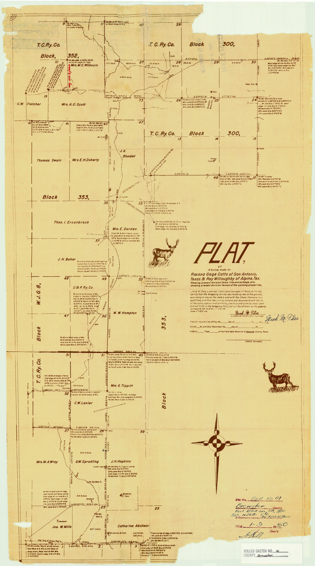
Plat of a survey made for Roxana Gage Catto of San Antonio, Texas & Ray Willoughby of Alpine, Tex. showing present division fence line and acreage, also showing present division fences of the adjoining properties
-
Map/Doc
5249
-
Collection
General Map Collection
-
Object Dates
1949/11/24 (Creation Date)
1950/1/9 (File Date)
-
People and Organizations
Nick M. Thee (Surveyor/Engineer)
-
Counties
Brewster
-
Subjects
Surveying Rolled Sketch
-
Height x Width
27.5 x 15.3 inches
69.9 x 38.9 cm
-
Medium
van dyke/brownline/sepia
-
Scale
1" = 500 varas
Part of: General Map Collection
Cochran County

Print $20.00
- Digital $50.00
Cochran County
1913
Size 28.9 x 20.8 inches
Map/Doc 66756
Tyler County Sketch File 16

Print $6.00
- Digital $50.00
Tyler County Sketch File 16
1860
Size 9.4 x 11.8 inches
Map/Doc 38661
Jim Hogg County Rolled Sketch 9

Print $20.00
- Digital $50.00
Jim Hogg County Rolled Sketch 9
1974
Size 18.2 x 19.8 inches
Map/Doc 6443
Kimble County Working Sketch 22

Print $20.00
- Digital $50.00
Kimble County Working Sketch 22
1929
Size 25.2 x 21.1 inches
Map/Doc 70090
Bailey County Working Sketch Graphic Index

Print $20.00
- Digital $50.00
Bailey County Working Sketch Graphic Index
1956
Size 47.7 x 30.5 inches
Map/Doc 76460
City of Mexia, Texas

Print $40.00
- Digital $50.00
City of Mexia, Texas
1961
Size 71.2 x 43.3 inches
Map/Doc 93671
Erath County Sketch File 33

Print $11.00
- Digital $50.00
Erath County Sketch File 33
1962
Size 14.4 x 8.8 inches
Map/Doc 22315


Flight Mission No. BRE-2P, Frame 134, Nueces County

Print $20.00
- Digital $50.00
Flight Mission No. BRE-2P, Frame 134, Nueces County
1956
Size 18.4 x 22.3 inches
Map/Doc 86807
Matagorda County Sketch File 27

Print $60.00
- Digital $50.00
Matagorda County Sketch File 27
1908
Size 11.8 x 15.7 inches
Map/Doc 30803
Jeff Davis County Sketch File 19

Print $10.00
- Digital $50.00
Jeff Davis County Sketch File 19
1908
Size 14.4 x 8.8 inches
Map/Doc 27973
You may also like
Austin Street Map & Guide

Digital $50.00
Austin Street Map & Guide
Size 35.3 x 23.2 inches
Map/Doc 94434
Flight Mission No. CUG-3P, Frame 83, Kleberg County

Print $20.00
- Digital $50.00
Flight Mission No. CUG-3P, Frame 83, Kleberg County
1956
Size 18.7 x 22.4 inches
Map/Doc 86258
Block No. 45 of the H. & T. C. R.R. Co. and Block No. 4T of the T. & N. O. R.R. Co. in Hansford and Ochiltree Cos. as resurveyed by J.L. Long, State Surveyor

Print $20.00
- Digital $50.00
Block No. 45 of the H. & T. C. R.R. Co. and Block No. 4T of the T. & N. O. R.R. Co. in Hansford and Ochiltree Cos. as resurveyed by J.L. Long, State Surveyor
1888
Size 34.1 x 28.1 inches
Map/Doc 75820
Orange County Working Sketch 12

Print $20.00
- Digital $50.00
Orange County Working Sketch 12
1922
Size 17.2 x 12.7 inches
Map/Doc 71344
Webb County Working Sketch 45

Print $20.00
- Digital $50.00
Webb County Working Sketch 45
1944
Size 28.1 x 28.9 inches
Map/Doc 72410
Upshur County Sketch File 16

Print $20.00
- Digital $50.00
Upshur County Sketch File 16
1873
Size 19.1 x 28.0 inches
Map/Doc 12506
Crockett County Rolled Sketch 78

Print $20.00
- Digital $50.00
Crockett County Rolled Sketch 78
1952
Size 20.5 x 19.5 inches
Map/Doc 5619
Harris County Working Sketch 23

Print $20.00
- Digital $50.00
Harris County Working Sketch 23
1926
Size 14.0 x 20.0 inches
Map/Doc 65915
Walker County

Print $20.00
- Digital $50.00
Walker County
1944
Size 44.8 x 38.5 inches
Map/Doc 63106
McMullen County Sketch File 35

Print $10.00
- Digital $50.00
McMullen County Sketch File 35
Size 9.7 x 8.5 inches
Map/Doc 31402
Terrell County Working Sketch 84c

Print $20.00
- Digital $50.00
Terrell County Working Sketch 84c
1992
Size 18.2 x 31.3 inches
Map/Doc 69607
Flight Mission No. DCL-6C, Frame 21, Kenedy County

Print $20.00
- Digital $50.00
Flight Mission No. DCL-6C, Frame 21, Kenedy County
1943
Size 18.7 x 22.5 inches
Map/Doc 85878