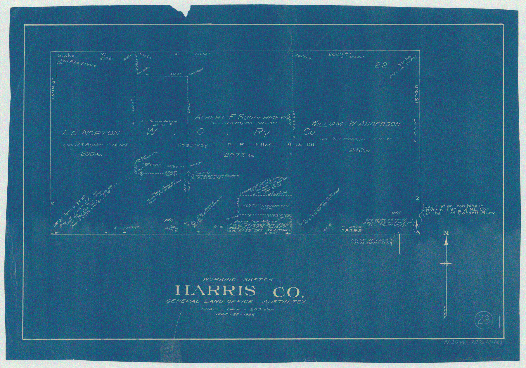
Harris County Working Sketch 23
-
Map/Doc
65915
-
Collection
General Map Collection
-
Object Dates
6/25/1926 (Creation Date)
-
Counties
Harris
-
Subjects
Surveying Working Sketch
-
Height x Width
14.0 x 20.0 inches
35.6 x 50.8 cm
-
Scale
1" = 200 varas
Part of: General Map Collection
Randall County

Print $20.00
- Digital $50.00
Randall County
1958
Size 43.0 x 35.1 inches
Map/Doc 73269
Hunt County Sketch File 4

Print $4.00
- Digital $50.00
Hunt County Sketch File 4
1852
Size 12.1 x 7.7 inches
Map/Doc 27087
Brazoria County Working Sketch 37

Print $40.00
- Digital $50.00
Brazoria County Working Sketch 37
1981
Size 43.5 x 66.0 inches
Map/Doc 67522
Red River County Rolled Sketch 10

Print $20.00
- Digital $50.00
Red River County Rolled Sketch 10
2005
Size 35.8 x 35.6 inches
Map/Doc 83316
El Paso County Boundary File 13

Print $37.00
- Digital $50.00
El Paso County Boundary File 13
Size 11.1 x 8.6 inches
Map/Doc 53161
Wise County Sketch File 3

Print $4.00
- Digital $50.00
Wise County Sketch File 3
1856
Size 10.2 x 8.0 inches
Map/Doc 40528
Texas, Copano Bay, Mission Bay and Fish Point

Print $40.00
- Digital $50.00
Texas, Copano Bay, Mission Bay and Fish Point
1934
Size 33.3 x 48.9 inches
Map/Doc 73433
Sutton County Sketch File 27B

Print $20.00
- Digital $50.00
Sutton County Sketch File 27B
Size 19.1 x 14.6 inches
Map/Doc 12384
La Salle County Rolled Sketch 27

Print $20.00
- Digital $50.00
La Salle County Rolled Sketch 27
1979
Size 29.0 x 38.2 inches
Map/Doc 6588
Right of Way and Track Map, Texas & New Orleans R.R. operated by the T. & N. O. R.R. Co., Rusk Branch

Print $40.00
- Digital $50.00
Right of Way and Track Map, Texas & New Orleans R.R. operated by the T. & N. O. R.R. Co., Rusk Branch
1918
Size 24.9 x 55.9 inches
Map/Doc 64242
Township 11 North Range 15 West, Western District, Louisiana

Print $20.00
- Digital $50.00
Township 11 North Range 15 West, Western District, Louisiana
1834
Size 19.7 x 24.6 inches
Map/Doc 65870
Dimmit County

Print $40.00
- Digital $50.00
Dimmit County
1916
Size 40.0 x 48.8 inches
Map/Doc 66806
You may also like
Flight Mission No. DQO-1K, Frame 152, Galveston County

Print $20.00
- Digital $50.00
Flight Mission No. DQO-1K, Frame 152, Galveston County
1952
Size 18.9 x 22.5 inches
Map/Doc 85005
Real County Rolled Sketch 1

Print $20.00
- Digital $50.00
Real County Rolled Sketch 1
1941
Size 20.6 x 28.9 inches
Map/Doc 7452
Flight Mission No. DCL-5C, Frame 3, Kenedy County

Print $20.00
- Digital $50.00
Flight Mission No. DCL-5C, Frame 3, Kenedy County
1943
Size 18.4 x 22.2 inches
Map/Doc 85828
Gonzales County Working Sketch 4a

Print $20.00
- Digital $50.00
Gonzales County Working Sketch 4a
1979
Size 30.9 x 32.2 inches
Map/Doc 63219
Martin County Working Sketch 1

Print $20.00
- Digital $50.00
Martin County Working Sketch 1
1922
Size 21.8 x 16.9 inches
Map/Doc 70819
Young County Working Sketch 8

Print $20.00
- Digital $50.00
Young County Working Sketch 8
1920
Size 17.3 x 12.6 inches
Map/Doc 62031
[Corpus Christi Bay, Padre Island, Mustang Island, Laguna de la Madre, King and Kenedy's Pasture]
![73046, [Corpus Christi Bay, Padre Island, Mustang Island, Laguna de la Madre, King and Kenedy's Pasture], General Map Collection](https://historictexasmaps.com/wmedia_w700/maps/73046.tif.jpg)
Print $20.00
- Digital $50.00
[Corpus Christi Bay, Padre Island, Mustang Island, Laguna de la Madre, King and Kenedy's Pasture]
Size 26.4 x 18.2 inches
Map/Doc 73046
Gaines County Working Sketch 11

Print $40.00
- Digital $50.00
Gaines County Working Sketch 11
1953
Size 68.4 x 33.4 inches
Map/Doc 69311
T. C. Ivey Ranch, Block D, Yoakum Co., Texas

Print $20.00
- Digital $50.00
T. C. Ivey Ranch, Block D, Yoakum Co., Texas
Size 17.1 x 14.6 inches
Map/Doc 91976
Hardin County Working Sketch 3

Print $3.00
- Digital $50.00
Hardin County Working Sketch 3
1906
Size 9.1 x 11.0 inches
Map/Doc 63401
Tom Green County

Print $20.00
- Digital $50.00
Tom Green County
1873
Size 22.4 x 36.9 inches
Map/Doc 1551
Culberson County Rolled Sketch 52

Print $20.00
- Digital $50.00
Culberson County Rolled Sketch 52
Size 19.0 x 24.8 inches
Map/Doc 5673