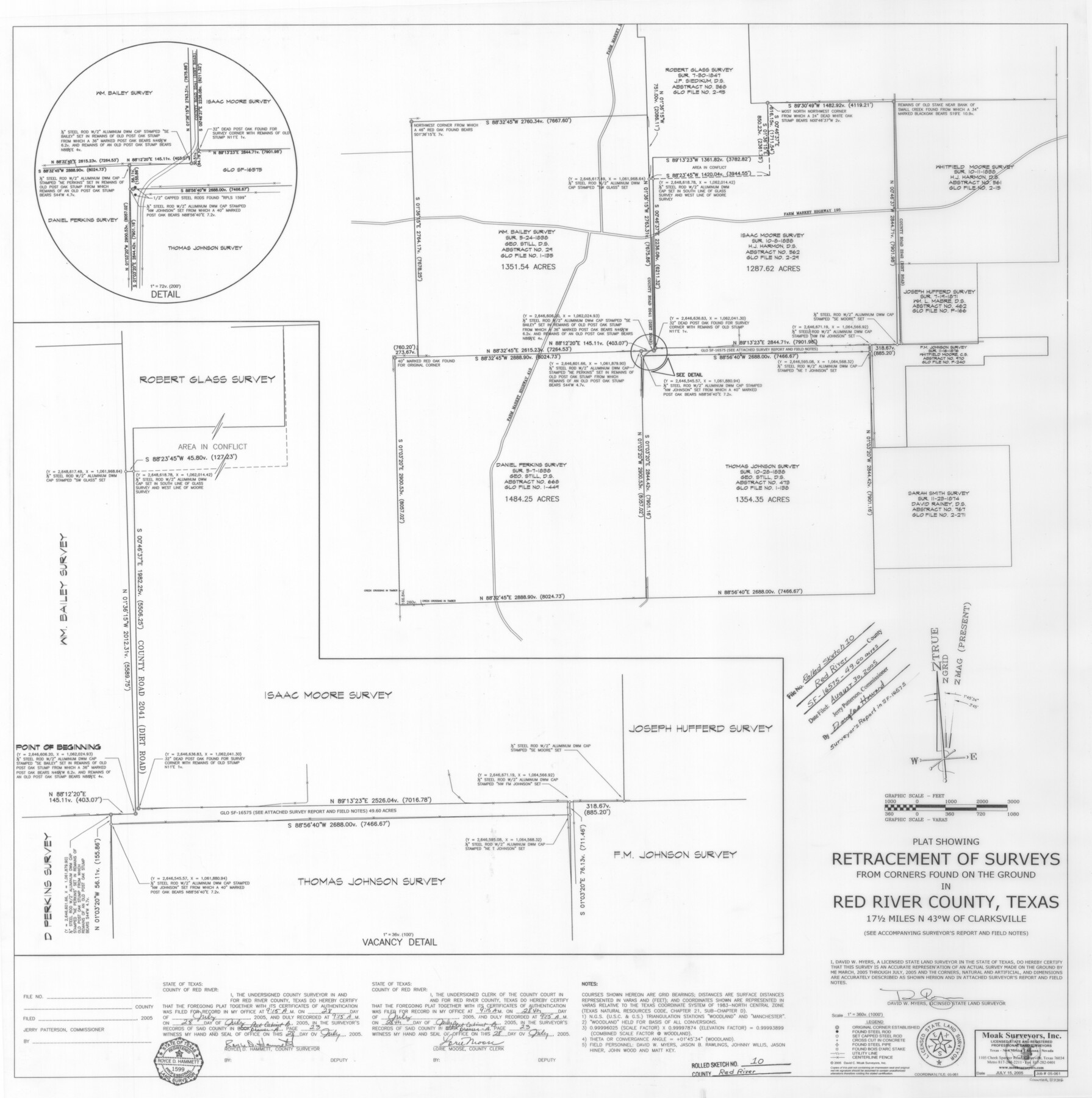
Red River County Rolled Sketch 10
Plat showing retracement of surveys from corners found on the ground in Red River County, Texas
-
Map/Doc
83316
-
Collection
General Map Collection
-
Object Dates
2005/7/15 (Creation Date)
2005/8/30 (File Date)
-
People and Organizations
David W. Myers (Surveyor/Engineer)
-
Counties
Red River
-
Subjects
Surveying Rolled Sketch
-
Height x Width
35.8 x 35.6 inches
90.9 x 90.4 cm
-
Medium
mylar, print
-
Scale
1" = 360 varas
-
Comments
See SF-16575 for surveyor's report.
Part of: General Map Collection
[Surveys along the Salado and Lampasas Rivers and Saltillo Creek]
![82159, [Surveys along the Salado and Lampasas Rivers and Saltillo Creek], General Map Collection](https://historictexasmaps.com/wmedia_w700/maps/82159.tif.jpg)
Print $2.00
- Digital $50.00
[Surveys along the Salado and Lampasas Rivers and Saltillo Creek]
1845
Size 13.1 x 7.7 inches
Map/Doc 82159
Wichita County Sketch File 12

Print $6.00
- Digital $50.00
Wichita County Sketch File 12
1881
Size 10.2 x 8.3 inches
Map/Doc 40074
Nueces County Sketch File 12A

Print $20.00
- Digital $50.00
Nueces County Sketch File 12A
1889
Size 28.1 x 23.0 inches
Map/Doc 42177
Kimble County Working Sketch 88

Print $20.00
- Digital $50.00
Kimble County Working Sketch 88
1976
Size 31.5 x 30.8 inches
Map/Doc 70156
Flight Mission No. CRC-4R, Frame 176, Chambers County

Print $20.00
- Digital $50.00
Flight Mission No. CRC-4R, Frame 176, Chambers County
1956
Size 18.6 x 22.3 inches
Map/Doc 84927
Goliad County Sketch File 23

Print $4.00
- Digital $50.00
Goliad County Sketch File 23
1877
Size 8.1 x 12.8 inches
Map/Doc 24295
Austin County

Print $20.00
- Digital $50.00
Austin County
1943
Size 40.1 x 42.5 inches
Map/Doc 73073
Kimble County Sketch File 28

Print $20.00
- Digital $50.00
Kimble County Sketch File 28
Size 23.3 x 17.8 inches
Map/Doc 11927
Trinity River, Hutchins Bridge Sheet

Print $20.00
- Digital $50.00
Trinity River, Hutchins Bridge Sheet
1922
Size 38.6 x 33.2 inches
Map/Doc 65190
Map of Tom Green Co.

Print $40.00
- Digital $50.00
Map of Tom Green Co.
1880
Size 42.5 x 74.3 inches
Map/Doc 82062
Starr County Sketch File 43

Print $28.00
- Digital $50.00
Starr County Sketch File 43
1941
Size 14.7 x 9.1 inches
Map/Doc 36991
Edwards County Sketch File 22

Print $8.00
- Digital $50.00
Edwards County Sketch File 22
1890
Size 14.4 x 8.9 inches
Map/Doc 21743
You may also like
Erath County Sketch File 8

Print $4.00
- Digital $50.00
Erath County Sketch File 8
Size 8.6 x 13.0 inches
Map/Doc 22269
Flight Mission No. DQO-2K, Frame 138, Galveston County

Print $20.00
- Digital $50.00
Flight Mission No. DQO-2K, Frame 138, Galveston County
1952
Size 18.8 x 22.6 inches
Map/Doc 85035
Matagorda Bay Oil Area, Matagorda, Calhoun & Jackson Cos.

Print $40.00
- Digital $50.00
Matagorda Bay Oil Area, Matagorda, Calhoun & Jackson Cos.
1927
Size 34.9 x 66.8 inches
Map/Doc 2934
Madison County Working Sketch 15

Print $20.00
- Digital $50.00
Madison County Working Sketch 15
2009
Size 42.3 x 36.0 inches
Map/Doc 89019
Burnet County Rolled Sketch 8

Print $40.00
- Digital $50.00
Burnet County Rolled Sketch 8
1971
Size 36.9 x 49.9 inches
Map/Doc 8554
Nueces County Sketch File 26 1/2

Print $20.00
- Digital $50.00
Nueces County Sketch File 26 1/2
1902
Size 18.4 x 23.0 inches
Map/Doc 42186
Flight Mission No. CGI-4N, Frame 174, Cameron County

Print $20.00
- Digital $50.00
Flight Mission No. CGI-4N, Frame 174, Cameron County
1955
Size 18.7 x 22.3 inches
Map/Doc 84677
San Jacinto River and Tributaries, Texas - Survey of 1939

Print $20.00
- Digital $50.00
San Jacinto River and Tributaries, Texas - Survey of 1939
1939
Size 27.7 x 40.4 inches
Map/Doc 60306
Map of Red River County

Print $20.00
- Digital $50.00
Map of Red River County
1842
Size 25.2 x 23.1 inches
Map/Doc 78369
Levelland, Hockley County, Texas

Print $20.00
- Digital $50.00
Levelland, Hockley County, Texas
1950
Size 13.1 x 14.9 inches
Map/Doc 92241
The Industrial Evolution of the agricultural wonderland of the southwest

Print $20.00
- Digital $50.00
The Industrial Evolution of the agricultural wonderland of the southwest
1927
Size 13.7 x 16.7 inches
Map/Doc 96760
Jack County Sketch File 14 1/2

Print $4.00
- Digital $50.00
Jack County Sketch File 14 1/2
1876
Size 8.5 x 12.7 inches
Map/Doc 27543