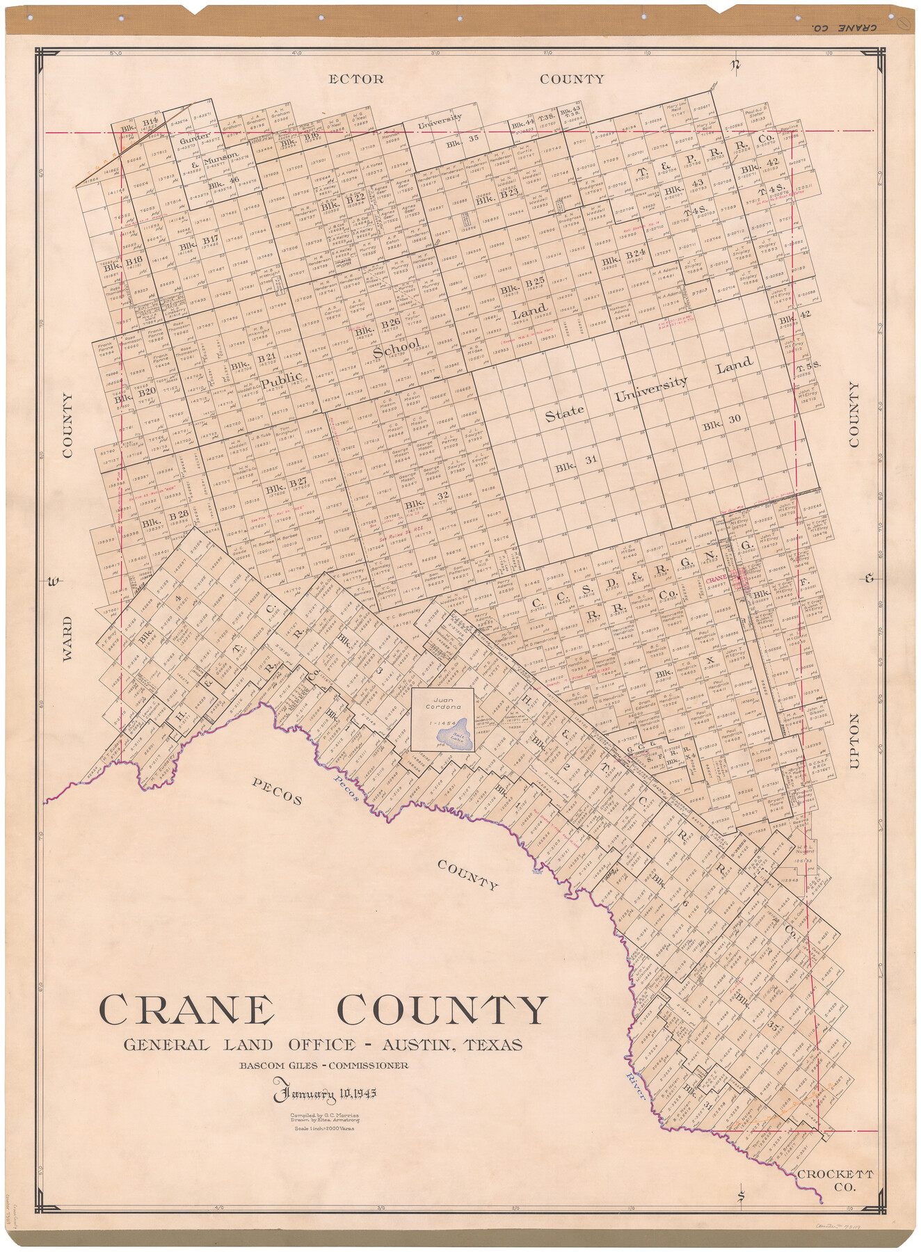
Crane County
-
Map/Doc
73119
-
Collection
General Map Collection
-
Object Dates
1945/1/10 (Creation Date)
-
People and Organizations
Texas General Land Office (Publisher)
Eltea Armstrong (Draftsman)
Bascom Giles (GLO Commissioner)
G.C. Morriss (Compiler)
-
Counties
Crane
-
Subjects
County
-
Height x Width
46.7 x 34.5 inches
118.6 x 87.6 cm
-
Comments
Hand lettered.
Note on reverse side: "Compilation completed January 10, 1945. Inking completed February 9, 1945. Tracing completed March 22, 1945. Placed in official use March 23, 1945. Replaced [on sticks] by copy June 15, 1946." -
Features
T&P
Flat Rock
Crane
Salt Lake
Pecos River
Horse Head Crossing
KCM&O
Part of: General Map Collection
Tom Green County Sketch File 53

Print $8.00
- Digital $50.00
Tom Green County Sketch File 53
1884
Size 14.2 x 9.1 inches
Map/Doc 38221
Crosby County Sketch File 16

Print $20.00
- Digital $50.00
Crosby County Sketch File 16
1904
Size 31.7 x 9.6 inches
Map/Doc 11251
Angelina County Working Sketch 32b

Print $20.00
- Digital $50.00
Angelina County Working Sketch 32b
1955
Size 23.0 x 28.6 inches
Map/Doc 67115
Duval County Sketch File 74

Print $42.00
- Digital $50.00
Duval County Sketch File 74
Size 10.1 x 8.8 inches
Map/Doc 21465
Aransas County Sketch File 21c

Print $4.00
- Digital $50.00
Aransas County Sketch File 21c
Size 8.7 x 14.0 inches
Map/Doc 13162
Childress County Working Sketch 1

Print $20.00
- Digital $50.00
Childress County Working Sketch 1
1907
Size 18.1 x 15.5 inches
Map/Doc 68017
Jack County Sketch File 2

Print $6.00
- Digital $50.00
Jack County Sketch File 2
1856
Size 8.8 x 8.0 inches
Map/Doc 27501
Fannin County Working Sketch 7

Print $20.00
- Digital $50.00
Fannin County Working Sketch 7
1952
Size 25.4 x 28.5 inches
Map/Doc 69161
Floyd County Sketch File 6

Print $2.00
- Digital $50.00
Floyd County Sketch File 6
Size 9.1 x 14.4 inches
Map/Doc 22696
Terrell County Sketch File 26

Print $38.00
- Digital $50.00
Terrell County Sketch File 26
1937
Size 10.9 x 8.2 inches
Map/Doc 37961
Hutchinson County Working Sketch 10

Print $20.00
- Digital $50.00
Hutchinson County Working Sketch 10
1920
Size 42.4 x 32.4 inches
Map/Doc 66368
Brewster County Sketch File N-15

Print $40.00
- Digital $50.00
Brewster County Sketch File N-15
Size 16.7 x 12.8 inches
Map/Doc 15641
You may also like
Plan of the Battle of Buena-Vista fought February 22nd and 23rd, 1847

Print $20.00
- Digital $50.00
Plan of the Battle of Buena-Vista fought February 22nd and 23rd, 1847
1847
Size 17.8 x 21.5 inches
Map/Doc 94112
Ward County Sketch File 9

Print $25.00
- Digital $50.00
Ward County Sketch File 9
1937
Size 10.8 x 8.9 inches
Map/Doc 39623
Kimble County Working Sketch 77

Print $20.00
- Digital $50.00
Kimble County Working Sketch 77
1970
Size 25.0 x 36.2 inches
Map/Doc 70145
Terrell County Working Sketch 62

Print $20.00
- Digital $50.00
Terrell County Working Sketch 62
1963
Size 32.2 x 34.4 inches
Map/Doc 69583
Trinity River, Emhouse Sheet/Chambers Creek

Print $6.00
- Digital $50.00
Trinity River, Emhouse Sheet/Chambers Creek
1931
Size 35.3 x 34.8 inches
Map/Doc 65232
Ater Heights Section 44, Block AK

Print $20.00
- Digital $50.00
Ater Heights Section 44, Block AK
1952
Size 11.9 x 18.9 inches
Map/Doc 92347
Township No. 4 South Range No. 17 West of the Indian Meridian

Print $20.00
- Digital $50.00
Township No. 4 South Range No. 17 West of the Indian Meridian
1875
Size 19.2 x 24.4 inches
Map/Doc 75164
General Highway Map, Yoakum County, Texas

Print $20.00
General Highway Map, Yoakum County, Texas
1940
Size 18.3 x 24.9 inches
Map/Doc 79285
[Sketch highlighting Bob Reid and Fred Turner surveys]
![91693, [Sketch highlighting Bob Reid and Fred Turner surveys], Twichell Survey Records](https://historictexasmaps.com/wmedia_w700/maps/91693-1.tif.jpg)
Print $20.00
- Digital $50.00
[Sketch highlighting Bob Reid and Fred Turner surveys]
Size 12.5 x 17.8 inches
Map/Doc 91693
Dallam County Sketch File 11

Print $4.00
- Digital $50.00
Dallam County Sketch File 11
1935
Size 11.8 x 7.2 inches
Map/Doc 20377
General Highway Map, San Augustine County, Texas

Print $20.00
General Highway Map, San Augustine County, Texas
1940
Size 24.8 x 18.3 inches
Map/Doc 79235
Railroad Track Map, H&TCRRCo., Falls County, Texas

Print $4.00
- Digital $50.00
Railroad Track Map, H&TCRRCo., Falls County, Texas
1918
Size 11.8 x 18.6 inches
Map/Doc 62836