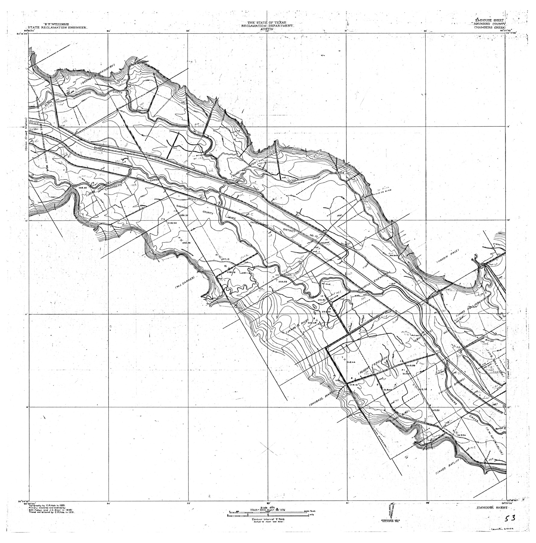
Trinity River, Emhouse Sheet/Chambers Creek
-
Map/Doc
65232
-
Collection
General Map Collection
-
Object Dates
1931 (Creation Date)
-
People and Organizations
Texas State Reclamation Department (Publisher)
Curtis R. Hale (Compiler)
Curtis R. Hale (Draftsman)
Curtis R. Hale (Surveyor/Engineer)
B.H. Faber (Surveyor/Engineer)
J.C. Blair (Surveyor/Engineer)
-
Counties
Navarro
-
Subjects
River Surveys Topographic
-
Height x Width
35.3 x 34.8 inches
89.7 x 88.4 cm
-
Comments
Emhouse Sheet located west of the Carl Switch Sheet and east of the Onion Creek Station Sheet.
Part of: General Map Collection
Frio County Rolled Sketch 14

Print $20.00
- Digital $50.00
Frio County Rolled Sketch 14
1949
Size 25.3 x 32.9 inches
Map/Doc 5921
San Patricio County Working Sketch 24
Print $20.00
- Digital $50.00
San Patricio County Working Sketch 24
1988
Size 30.9 x 43.0 inches
Map/Doc 63786
Jefferson County Rolled Sketch 33

Print $20.00
- Digital $50.00
Jefferson County Rolled Sketch 33
1956
Size 46.8 x 27.5 inches
Map/Doc 6393
[Beaumont, Sour Lake and Western Ry. Right of Way and Alignment - Frisco]
![64130, [Beaumont, Sour Lake and Western Ry. Right of Way and Alignment - Frisco], General Map Collection](https://historictexasmaps.com/wmedia_w700/maps/64130.tif.jpg)
Print $20.00
- Digital $50.00
[Beaumont, Sour Lake and Western Ry. Right of Way and Alignment - Frisco]
1910
Size 20.3 x 45.9 inches
Map/Doc 64130
Neches River, Big Eddy Bridge Sheet

Print $20.00
- Digital $50.00
Neches River, Big Eddy Bridge Sheet
1938
Size 41.1 x 21.0 inches
Map/Doc 65084
Potter County Rolled Sketch 13

Print $20.00
- Digital $50.00
Potter County Rolled Sketch 13
2004
Size 19.2 x 23.2 inches
Map/Doc 82479
Hutchinson County Rolled Sketch 6

Print $20.00
- Digital $50.00
Hutchinson County Rolled Sketch 6
1906
Size 33.2 x 24.2 inches
Map/Doc 6278
Map of section no. 7 of a survey of Padre Island made for the Office of the Attorney General of the State of Texas

Print $40.00
- Digital $50.00
Map of section no. 7 of a survey of Padre Island made for the Office of the Attorney General of the State of Texas
1941
Size 56.3 x 41.2 inches
Map/Doc 2263
Milam County Boundary File 6c

Print $2.00
- Digital $50.00
Milam County Boundary File 6c
Size 11.2 x 8.5 inches
Map/Doc 57250
Terry County Sketch File 2

Print $8.00
- Digital $50.00
Terry County Sketch File 2
Size 8.9 x 11.4 inches
Map/Doc 38012
El Paso County Rolled Sketch 52

Print $20.00
- Digital $50.00
El Paso County Rolled Sketch 52
1929
Size 18.4 x 24.4 inches
Map/Doc 5845
Map of east part of West Bay & SW part of Galveston Bay, Galveston County showing subdivision for mineral development

Print $40.00
- Digital $50.00
Map of east part of West Bay & SW part of Galveston Bay, Galveston County showing subdivision for mineral development
Size 69.6 x 48.0 inches
Map/Doc 65804
You may also like
Flight Mission No. DQO-2K, Frame 145, Galveston County

Print $20.00
- Digital $50.00
Flight Mission No. DQO-2K, Frame 145, Galveston County
1952
Size 18.8 x 22.5 inches
Map/Doc 85042
Acts of the Visit of the Royal Commissioners (sometimes referred to as the “Visita General”) - Camargo

Acts of the Visit of the Royal Commissioners (sometimes referred to as the “Visita General”) - Camargo
1767
Size 14.3 x 9.5 inches
Map/Doc 94254
Travis County Rolled Sketch 49

Print $20.00
- Digital $50.00
Travis County Rolled Sketch 49
Size 43.0 x 39.9 inches
Map/Doc 10017
Jefferson County Sketch File 56

Print $34.00
- Digital $50.00
Jefferson County Sketch File 56
2007
Map/Doc 93427
Wise County Sketch File 14

Print $24.00
- Digital $50.00
Wise County Sketch File 14
1855
Size 12.8 x 8.2 inches
Map/Doc 40548
[Map to illustrate possible mineral resources on the lands belonging to the University of Texas]
![62963, [Map to illustrate possible mineral resources on the lands belonging to the University of Texas], General Map Collection](https://historictexasmaps.com/wmedia_w700/maps/62963.tif.jpg)
Print $2.00
- Digital $50.00
[Map to illustrate possible mineral resources on the lands belonging to the University of Texas]
Size 10.2 x 7.7 inches
Map/Doc 62963
Texas Railroad Map

Print $20.00
- Digital $50.00
Texas Railroad Map
1981
Size 34.8 x 35.6 inches
Map/Doc 2101
Travis County Working Sketch 41

Print $20.00
- Digital $50.00
Travis County Working Sketch 41
1974
Size 34.4 x 31.3 inches
Map/Doc 69425
[Santa Rosa Leagues, Brooks & Kenedy Counties, Texas]
![10774, [Santa Rosa Leagues, Brooks & Kenedy Counties, Texas], Maddox Collection](https://historictexasmaps.com/wmedia_w700/maps/10774-1.tif.jpg)
Print $20.00
- Digital $50.00
[Santa Rosa Leagues, Brooks & Kenedy Counties, Texas]
Size 21.0 x 24.6 inches
Map/Doc 10774
Hidalgo County Rolled Sketch 16

Print $40.00
- Digital $50.00
Hidalgo County Rolled Sketch 16
1963
Size 68.9 x 42.2 inches
Map/Doc 9171
Map of Main Line Houston & Tex. Centr. Railway from Dallas to Red River City

Print $40.00
- Digital $50.00
Map of Main Line Houston & Tex. Centr. Railway from Dallas to Red River City
Size 37.1 x 84.9 inches
Map/Doc 64089
Jefferson County Rolled Sketch 35

Print $20.00
- Digital $50.00
Jefferson County Rolled Sketch 35
1957
Size 37.9 x 26.0 inches
Map/Doc 6394