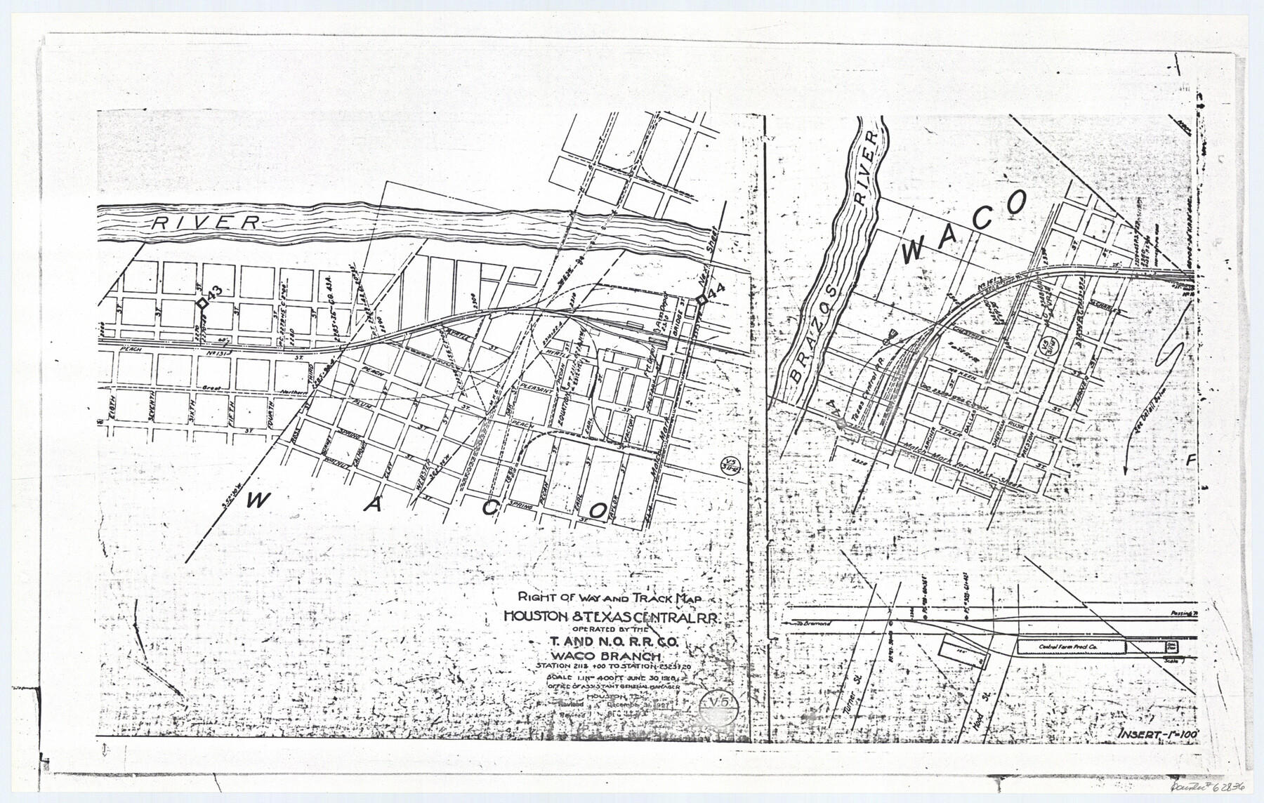
Railroad Track Map, H&TCRRCo., Falls County, Texas
Right of Way and Track Map
K-7-79 flat folder
-
Map/Doc
62836
-
Collection
General Map Collection
-
Object Dates
1918 (Creation Date)
-
Counties
Falls
-
Subjects
Railroads
-
Height x Width
11.8 x 18.6 inches
30.0 x 47.2 cm
-
Comments
Operated by the Texas and New Orleans Railroad Company, Waco Branch.
Part of: General Map Collection
Flight Mission No. BQY-4M, Frame 126, Harris County

Print $20.00
- Digital $50.00
Flight Mission No. BQY-4M, Frame 126, Harris County
1953
Size 18.5 x 22.2 inches
Map/Doc 85295
Flight Mission No. CLL-3N, Frame 37, Willacy County

Print $20.00
- Digital $50.00
Flight Mission No. CLL-3N, Frame 37, Willacy County
1954
Size 18.6 x 22.2 inches
Map/Doc 87095
Flight Mission No. CRC-3R, Frame 209, Chambers County

Print $20.00
- Digital $50.00
Flight Mission No. CRC-3R, Frame 209, Chambers County
1956
Size 18.6 x 22.3 inches
Map/Doc 84864
Central Part of Jeff Davis Co.

Print $40.00
- Digital $50.00
Central Part of Jeff Davis Co.
1982
Size 56.3 x 43.9 inches
Map/Doc 95543
Hutchinson County Sketch File 27

Print $20.00
- Digital $50.00
Hutchinson County Sketch File 27
Size 21.0 x 24.9 inches
Map/Doc 11817
Howard County Sketch File 9

Print $20.00
- Digital $50.00
Howard County Sketch File 9
Size 19.4 x 15.9 inches
Map/Doc 11797
Jeff Davis County Working Sketch 14

Print $20.00
- Digital $50.00
Jeff Davis County Working Sketch 14
1949
Size 21.5 x 25.8 inches
Map/Doc 66509
Terrell County Sketch File 28

Print $20.00
- Digital $50.00
Terrell County Sketch File 28
1939
Size 18.3 x 22.8 inches
Map/Doc 12425
Montague County Working Sketch 24

Print $20.00
- Digital $50.00
Montague County Working Sketch 24
1953
Size 21.9 x 27.6 inches
Map/Doc 71090
Flight Mission No. DIX-8P, Frame 59, Aransas County

Print $20.00
- Digital $50.00
Flight Mission No. DIX-8P, Frame 59, Aransas County
1956
Size 18.7 x 22.4 inches
Map/Doc 83890
Howard County Sketch File 2a

Print $20.00
- Digital $50.00
Howard County Sketch File 2a
1909
Size 32.8 x 25.6 inches
Map/Doc 11792
Flight Mission No. DQN-2K, Frame 127, Calhoun County

Print $20.00
- Digital $50.00
Flight Mission No. DQN-2K, Frame 127, Calhoun County
1953
Size 18.4 x 22.3 inches
Map/Doc 84301
You may also like
Parker County Sketch File 15A

Print $20.00
- Digital $50.00
Parker County Sketch File 15A
1875
Size 28.5 x 13.6 inches
Map/Doc 12144
McKinney Bayou Sheet, Bowie County, Red River

Print $20.00
- Digital $50.00
McKinney Bayou Sheet, Bowie County, Red River
1933
Size 37.1 x 33.5 inches
Map/Doc 75272
[Sketch in DeWitt County]
![78383, [Sketch in DeWitt County], General Map Collection](https://historictexasmaps.com/wmedia_w700/maps/78383.tif.jpg)
Print $3.00
- Digital $50.00
[Sketch in DeWitt County]
Size 9.3 x 10.1 inches
Map/Doc 78383
Grayson County Working Sketch 5

Print $20.00
- Digital $50.00
Grayson County Working Sketch 5
1939
Size 28.4 x 40.6 inches
Map/Doc 63244
Red River County Working Sketch 55

Print $20.00
- Digital $50.00
Red River County Working Sketch 55
1971
Size 29.4 x 31.1 inches
Map/Doc 72038
Camp County Working Sketch 2

Print $20.00
- Digital $50.00
Camp County Working Sketch 2
1975
Size 24.8 x 24.5 inches
Map/Doc 67878
Map of Surveys made in Fisher and Miller's Colony

Print $40.00
- Digital $50.00
Map of Surveys made in Fisher and Miller's Colony
1848
Size 48.4 x 57.7 inches
Map/Doc 16830
[T. A. Thomson Blk. T4 and vicinity]
![90398, [T. A. Thomson Blk. T4 and vicinity], Twichell Survey Records](https://historictexasmaps.com/wmedia_w700/maps/90398-1.tif.jpg)
Print $20.00
- Digital $50.00
[T. A. Thomson Blk. T4 and vicinity]
Size 14.6 x 20.2 inches
Map/Doc 90398
Hardin County Rolled Sketch 4

Print $20.00
- Digital $50.00
Hardin County Rolled Sketch 4
1938
Size 30.1 x 28.7 inches
Map/Doc 6077
Potter County Sketch File 23

Print $4.00
- Digital $50.00
Potter County Sketch File 23
Size 11.1 x 8.7 inches
Map/Doc 34421
Flight Mission No. BRA-6M, Frame 85, Jefferson County

Print $20.00
- Digital $50.00
Flight Mission No. BRA-6M, Frame 85, Jefferson County
1953
Size 18.6 x 22.4 inches
Map/Doc 85429
History Salvaged from the Sea

History Salvaged from the Sea
1977
Size 23.0 x 30.4 inches
Map/Doc 96836