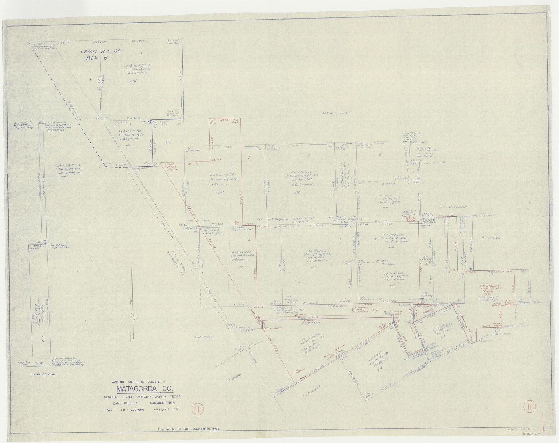
Matagorda County Working Sketch 11
-
Map/Doc
70869
-
Collection
General Map Collection
-
Object Dates
11/25/1957 (Creation Date)
-
Counties
Matagorda
-
Subjects
Surveying Working Sketch
-
Height x Width
34.6 x 43.6 inches
87.9 x 110.7 cm
-
Scale
1" = 300 varas
Part of: General Map Collection
Parker County Sketch File 50

Print $68.00
- Digital $50.00
Parker County Sketch File 50
2022
Size 11.0 x 8.5 inches
Map/Doc 96679
Tarrant County

Print $40.00
- Digital $50.00
Tarrant County
1942
Size 48.3 x 38.0 inches
Map/Doc 95649
Sabine Bank to East Bay including Heald Bank

Print $20.00
- Digital $50.00
Sabine Bank to East Bay including Heald Bank
1967
Size 45.1 x 34.3 inches
Map/Doc 69848
Edwards County Working Sketch 115

Print $20.00
- Digital $50.00
Edwards County Working Sketch 115
1973
Size 39.6 x 43.9 inches
Map/Doc 68991
Flight Mission No. BRA-7M, Frame 132, Jefferson County

Print $20.00
- Digital $50.00
Flight Mission No. BRA-7M, Frame 132, Jefferson County
1953
Size 18.5 x 19.6 inches
Map/Doc 85526
Atascosa County Rolled Sketch 22

Print $40.00
- Digital $50.00
Atascosa County Rolled Sketch 22
1917
Size 25.9 x 57.4 inches
Map/Doc 8920
San Augustine County Sketch File 14

Print $22.00
San Augustine County Sketch File 14
1888
Size 13.2 x 12.6 inches
Map/Doc 35662
Flight Mission No. CLL-1N, Frame 160, Willacy County

Print $20.00
- Digital $50.00
Flight Mission No. CLL-1N, Frame 160, Willacy County
1954
Size 18.3 x 22.0 inches
Map/Doc 87051
Moore County Sketch File 2

Print $36.00
- Digital $50.00
Moore County Sketch File 2
Size 14.2 x 8.6 inches
Map/Doc 31929
Copy of Surveyor's Field Book, Morris Browning - In Blocks 7, 5 & 4, I&GNRRCo., Hutchinson and Carson Counties, Texas

Print $2.00
- Digital $50.00
Copy of Surveyor's Field Book, Morris Browning - In Blocks 7, 5 & 4, I&GNRRCo., Hutchinson and Carson Counties, Texas
1888
Size 6.9 x 8.8 inches
Map/Doc 62263
Gregg County Working Sketch 5

Print $20.00
- Digital $50.00
Gregg County Working Sketch 5
1933
Size 18.0 x 42.6 inches
Map/Doc 63271
La Salle County Working Sketch 19

Print $20.00
- Digital $50.00
La Salle County Working Sketch 19
1941
Size 24.6 x 31.4 inches
Map/Doc 70320
You may also like

Kendall County Sketch File 25

Print $6.00
- Digital $50.00
Kendall County Sketch File 25
1950
Size 11.2 x 8.6 inches
Map/Doc 28722
Zavala County Rolled Sketch 33

Print $20.00
- Digital $50.00
Zavala County Rolled Sketch 33
Size 19.3 x 26.9 inches
Map/Doc 8334
Kimble County Working Sketch 33

Print $20.00
- Digital $50.00
Kimble County Working Sketch 33
1945
Size 29.8 x 29.2 inches
Map/Doc 70101
Hockley County Working Sketch 3

Print $20.00
- Digital $50.00
Hockley County Working Sketch 3
1962
Size 35.4 x 22.0 inches
Map/Doc 66193
Live Oak County Boundary File 1

Print $24.00
- Digital $50.00
Live Oak County Boundary File 1
Size 9.0 x 4.2 inches
Map/Doc 56387
Erath County Working Sketch 23

Print $20.00
- Digital $50.00
Erath County Working Sketch 23
1966
Size 38.2 x 29.0 inches
Map/Doc 69104
Hudspeth County Working Sketch 5

Print $20.00
- Digital $50.00
Hudspeth County Working Sketch 5
1921
Size 27.8 x 38.8 inches
Map/Doc 66286
Randall County Rolled Sketch 6

Print $20.00
- Digital $50.00
Randall County Rolled Sketch 6
Size 25.0 x 23.9 inches
Map/Doc 7426

Flight Mission No. CRC-3R, Frame 198, Chambers County

Print $20.00
- Digital $50.00
Flight Mission No. CRC-3R, Frame 198, Chambers County
1956
Size 18.5 x 22.2 inches
Map/Doc 84853
Potter County Boundary File 6a

Print $20.00
- Digital $50.00
Potter County Boundary File 6a
Size 43.8 x 15.6 inches
Map/Doc 58039