Crockett County Sketch File 28
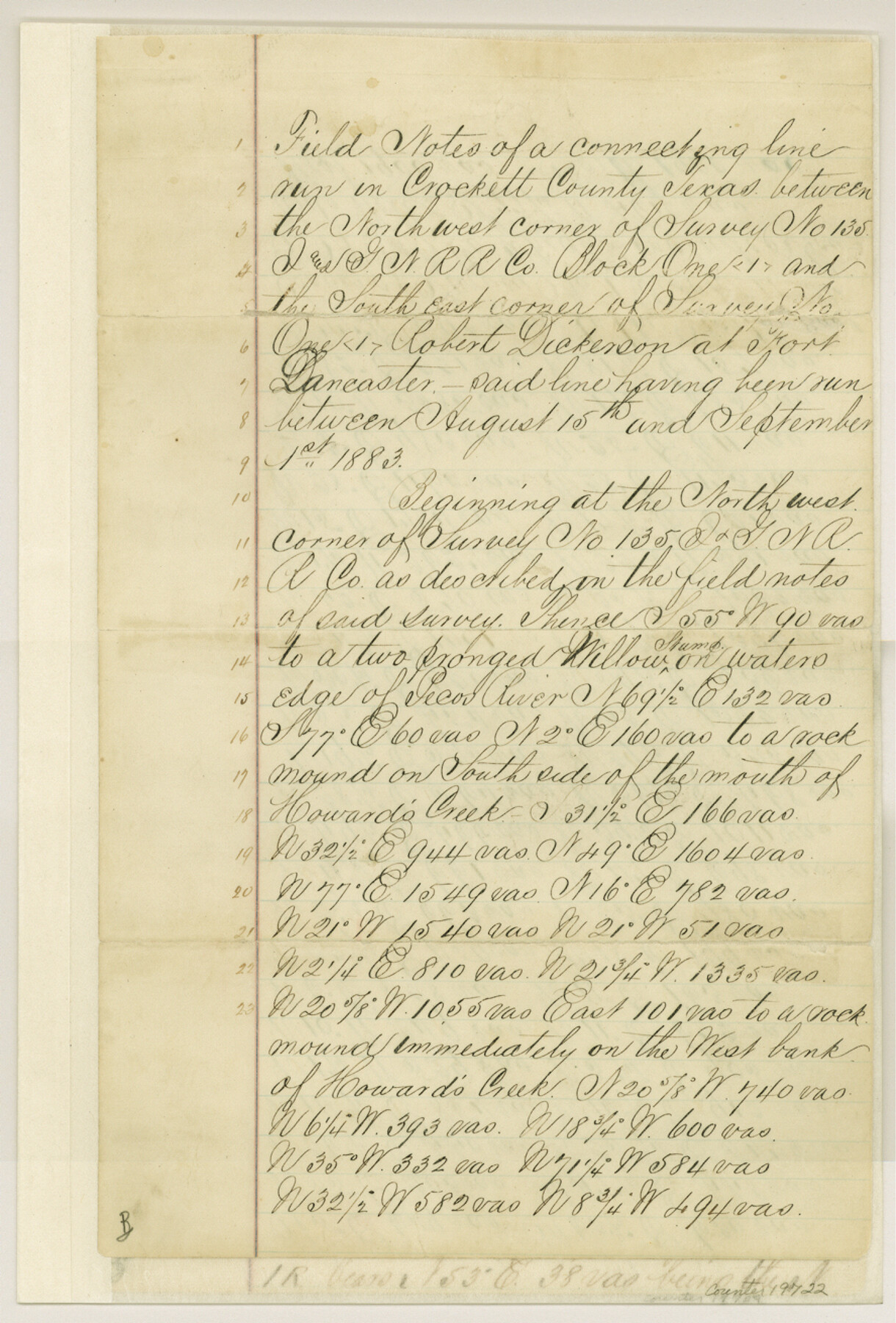
[Connecting line between northwest corner of survey 135, I. & G. N. RR. Co. and southeast corner of survey 1 at Fort Lancaster]
-
Map/Doc
19722
-
Collection
General Map Collection
-
Object Dates
1884/2/28 (Creation Date)
1884/3/1 (File Date)
1883/9/1 (Survey Date)
-
People and Organizations
E.A. Giraud (Surveyor/Engineer)
G. Van Rider (Chainman)
J.W. Johnson (Chainman)
-
Counties
Crockett
-
Subjects
Surveying Sketch File
-
Height x Width
13.1 x 8.9 inches
33.3 x 22.6 cm
-
Medium
paper, manuscript
-
Features
Fort Lancaster
Pecos River
Howard's Creek
Howard's Well
Part of: General Map Collection
Nueces County Rolled Sketch 81

Print $278.00
- Digital $50.00
Nueces County Rolled Sketch 81
1982
Size 24.3 x 36.2 inches
Map/Doc 6960
Hemphill County Sketch File 8

Print $9.00
- Digital $50.00
Hemphill County Sketch File 8
Size 14.3 x 8.9 inches
Map/Doc 26308
Harris County Historic Topographic 29

Print $20.00
- Digital $50.00
Harris County Historic Topographic 29
1915
Size 29.1 x 23.0 inches
Map/Doc 65840
Flight Mission No. BQR-9K, Frame 45, Brazoria County

Print $20.00
- Digital $50.00
Flight Mission No. BQR-9K, Frame 45, Brazoria County
1952
Size 18.7 x 22.3 inches
Map/Doc 84049
Surveys in Reeves and Culberson Counties, Texas and Pacific Railroad Company, Blocks 58, 59, 60, and 61

Print $20.00
- Digital $50.00
Surveys in Reeves and Culberson Counties, Texas and Pacific Railroad Company, Blocks 58, 59, 60, and 61
1937
Size 30.7 x 25.3 inches
Map/Doc 2250
Bexar County Working Sketch 24

Print $20.00
- Digital $50.00
Bexar County Working Sketch 24
1989
Size 40.8 x 27.5 inches
Map/Doc 67340
Rusk County Sketch File 19

Print $4.00
Rusk County Sketch File 19
Size 13.0 x 8.2 inches
Map/Doc 35526
Duval County Sketch File 8a

Print $4.00
- Digital $50.00
Duval County Sketch File 8a
1875
Size 10.9 x 8.8 inches
Map/Doc 21298
Flight Mission No. DCL-7C, Frame 78, Kenedy County

Print $20.00
- Digital $50.00
Flight Mission No. DCL-7C, Frame 78, Kenedy County
1943
Size 15.3 x 15.2 inches
Map/Doc 86064
[F. W. & D. C. Ry. Co. Alignment and Right of Way Map, Clay County]
![64729, [F. W. & D. C. Ry. Co. Alignment and Right of Way Map, Clay County], General Map Collection](https://historictexasmaps.com/wmedia_w700/maps/64729-1.tif.jpg)
Print $20.00
- Digital $50.00
[F. W. & D. C. Ry. Co. Alignment and Right of Way Map, Clay County]
1927
Size 18.5 x 11.7 inches
Map/Doc 64729
Hutchinson County Working Sketch 17

Print $40.00
- Digital $50.00
Hutchinson County Working Sketch 17
1955
Size 47.2 x 128.6 inches
Map/Doc 66375
Freestone County Working Sketch 12

Print $40.00
- Digital $50.00
Freestone County Working Sketch 12
1980
Size 54.5 x 38.6 inches
Map/Doc 69254
You may also like
Fort Bend County Sketch File 15

Print $5.00
- Digital $50.00
Fort Bend County Sketch File 15
Size 11.9 x 12.8 inches
Map/Doc 22925
Real County Sketch File 7

Print $8.00
- Digital $50.00
Real County Sketch File 7
1931
Size 11.3 x 8.8 inches
Map/Doc 35055
Bastrop County

Print $40.00
- Digital $50.00
Bastrop County
1917
Size 48.0 x 40.5 inches
Map/Doc 4881
General Highway Map, Blanco County, Texas

Print $20.00
General Highway Map, Blanco County, Texas
1940
Size 25.0 x 18.5 inches
Map/Doc 79020
Panola County Rolled Sketch 4A

Print $40.00
- Digital $50.00
Panola County Rolled Sketch 4A
1953
Size 50.0 x 24.8 inches
Map/Doc 9677
Red River County Working Sketch 19

Print $40.00
- Digital $50.00
Red River County Working Sketch 19
1955
Size 55.0 x 38.6 inches
Map/Doc 72002
Brewster County Rolled Sketch 49B

Print $20.00
- Digital $50.00
Brewster County Rolled Sketch 49B
Size 14.2 x 24.2 inches
Map/Doc 5225
Texas-Oklahoma Clara Quadrangle

Print $20.00
- Digital $50.00
Texas-Oklahoma Clara Quadrangle
1937
Size 20.3 x 16.9 inches
Map/Doc 75105
Irion County Sketch File 11

Print $20.00
- Digital $50.00
Irion County Sketch File 11
1937
Size 22.2 x 17.5 inches
Map/Doc 11826
Plot of surveys on Sims Bayou

Print $2.00
- Digital $50.00
Plot of surveys on Sims Bayou
1844
Size 6.8 x 8.3 inches
Map/Doc 26
Gregg County Boundary File 9

Print $16.00
- Digital $50.00
Gregg County Boundary File 9
Size 4.1 x 14.9 inches
Map/Doc 54023
