Hemphill County Sketch File 8
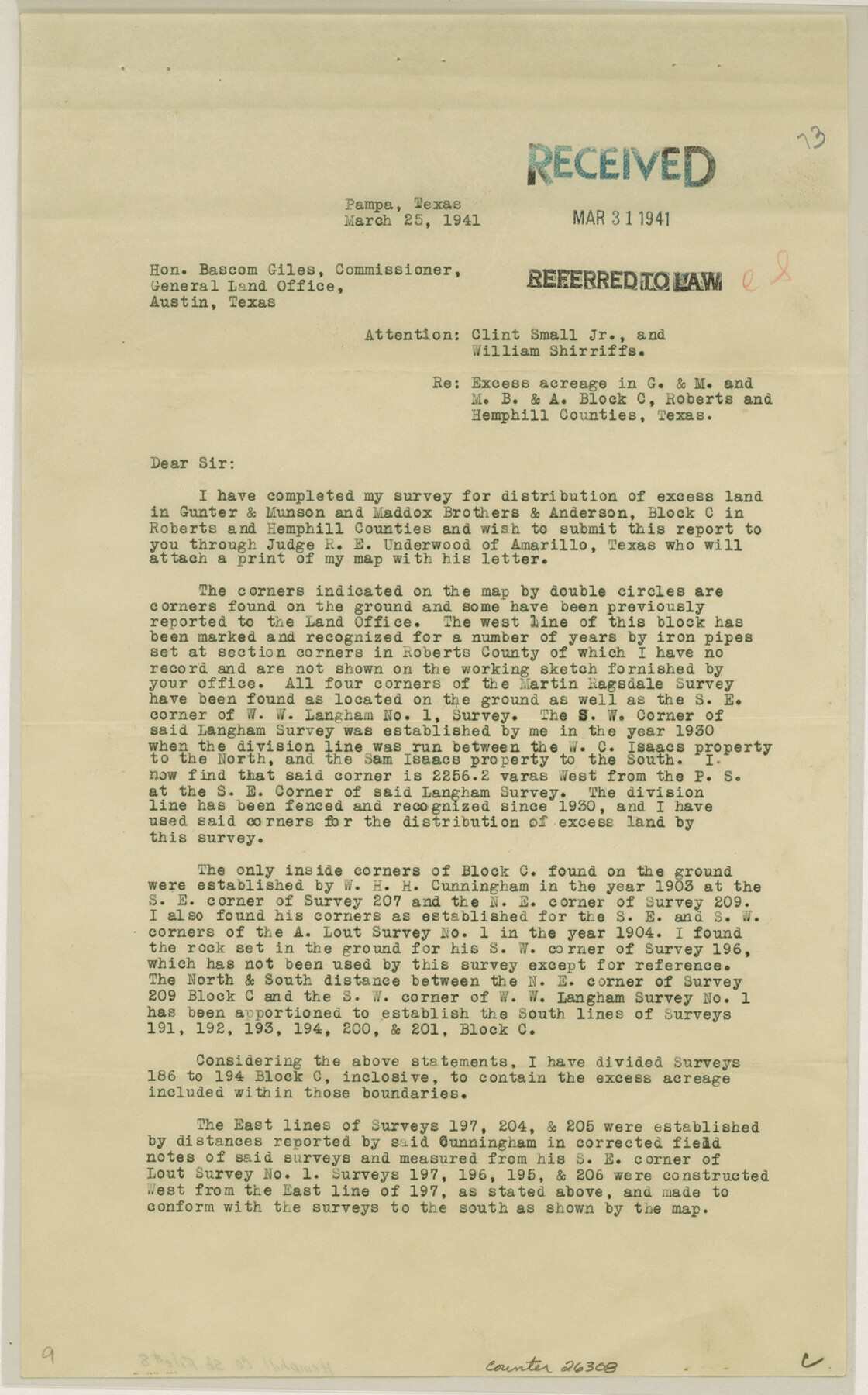
[Survey report on excess acreage in G. & M. and M. B. & A. Block C]
-
Map/Doc
26308
-
Collection
General Map Collection
-
Object Dates
3/25/1941 (Correspondence Date)
1930 (Survey Date)
1903 (Survey Date)
1904 (Survey Date)
1887 (Survey Date)
1888 (Survey Date)
3/31/1941 (File Date)
-
People and Organizations
A.H. Doucette (Surveyor/Engineer)
W.H.H. Cunningham (Surveyor/Engineer)
-
Counties
Hemphill Roberts
-
Subjects
Surveying Sketch File
-
Height x Width
14.3 x 8.9 inches
36.3 x 22.6 cm
-
Medium
paper, print
-
Comments
See Hemphill County Rolled Sketch 12 (9154) and Hemphill County Rolled Sketch 13 (6193) for sketches.
-
Features
Canadian
Landers Street
Cheyenne Street
Gem City Public Road
Related maps
Hemphill County Rolled Sketch 13

Print $20.00
- Digital $50.00
Hemphill County Rolled Sketch 13
1905
Size 20.7 x 28.9 inches
Map/Doc 6193
Hemphill County Rolled Sketch 12

Print $20.00
- Digital $50.00
Hemphill County Rolled Sketch 12
1941
Size 36.0 x 45.1 inches
Map/Doc 9154
Part of: General Map Collection
Flight Mission No. BQR-9K, Frame 47, Brazoria County

Print $20.00
- Digital $50.00
Flight Mission No. BQR-9K, Frame 47, Brazoria County
1952
Size 18.7 x 22.4 inches
Map/Doc 84051
Flight Mission No. DAG-18K, Frame 73, Matagorda County

Print $20.00
- Digital $50.00
Flight Mission No. DAG-18K, Frame 73, Matagorda County
1952
Size 18.5 x 22.2 inches
Map/Doc 86366
Burleson County Working Sketch 12

Print $20.00
- Digital $50.00
Burleson County Working Sketch 12
1980
Size 20.6 x 12.0 inches
Map/Doc 67731
Comal County Sketch File 7

Print $4.00
- Digital $50.00
Comal County Sketch File 7
Size 13.5 x 8.3 inches
Map/Doc 19011
Crockett County Sketch File 62

Print $6.00
- Digital $50.00
Crockett County Sketch File 62
1927
Size 14.2 x 8.8 inches
Map/Doc 19848
McCulloch County Boundary File 64

Print $36.00
- Digital $50.00
McCulloch County Boundary File 64
Size 9.2 x 8.9 inches
Map/Doc 56919
Nueces County Rolled Sketch 76

Print $20.00
- Digital $50.00
Nueces County Rolled Sketch 76
1981
Size 18.3 x 23.6 inches
Map/Doc 6937
Carson County

Print $20.00
- Digital $50.00
Carson County
1932
Size 42.0 x 38.5 inches
Map/Doc 73100
Cass County Sketch File 6

Print $4.00
- Digital $50.00
Cass County Sketch File 6
1852
Size 8.4 x 8.8 inches
Map/Doc 17406
Nueces County Sketch File 37

Print $2.00
- Digital $50.00
Nueces County Sketch File 37
1913
Size 11.2 x 8.6 inches
Map/Doc 32614
Jim Hogg County Rolled Sketch 9

Print $20.00
- Digital $50.00
Jim Hogg County Rolled Sketch 9
1974
Size 18.2 x 19.8 inches
Map/Doc 6443
Leon County Rolled Sketch 35

Print $20.00
- Digital $50.00
Leon County Rolled Sketch 35
2018
Size 30.7 x 21.3 inches
Map/Doc 95288
You may also like
Brazos River, Brazos River Sheet 1

Print $4.00
- Digital $50.00
Brazos River, Brazos River Sheet 1
1926
Size 21.5 x 25.4 inches
Map/Doc 65293
Victoria County, Texas

Print $20.00
- Digital $50.00
Victoria County, Texas
1879
Size 26.5 x 22.8 inches
Map/Doc 511
Shelby County Working Sketch 23a

Print $20.00
- Digital $50.00
Shelby County Working Sketch 23a
1983
Size 28.1 x 31.0 inches
Map/Doc 63876
Kleberg County Rolled Sketch 10-36

Print $20.00
- Digital $50.00
Kleberg County Rolled Sketch 10-36
1952
Size 35.3 x 30.7 inches
Map/Doc 9382
Zavala County Sketch File 39

Print $4.00
- Digital $50.00
Zavala County Sketch File 39
1884
Size 14.4 x 8.7 inches
Map/Doc 41404
![91462, [Block B7], Twichell Survey Records](https://historictexasmaps.com/wmedia_w700/maps/91462-1.tif.jpg)
The Mexican Municipality of Washington. Proposed Creation, ca Spring 1835

Print $20.00
The Mexican Municipality of Washington. Proposed Creation, ca Spring 1835
2020
Size 13.1 x 21.7 inches
Map/Doc 96035
Map of Hays County, Texas

Print $20.00
- Digital $50.00
Map of Hays County, Texas
1880
Size 24.3 x 21.4 inches
Map/Doc 5029
Fort Worth, Tarrant Co[unty], Texas
![89081, Fort Worth, Tarrant Co[unty], Texas, Non-GLO Digital Images](https://historictexasmaps.com/wmedia_w700/maps/89081.tif.jpg)
Print $20.00
Fort Worth, Tarrant Co[unty], Texas
1876
Size 14.9 x 18.0 inches
Map/Doc 89081

National Map Company's Ohio showing Counties, Townships, Cities, Villages, Post Offices, Steam and Electric Railways, With Stations and Distances Between Stations

Print $20.00
- Digital $50.00
National Map Company's Ohio showing Counties, Townships, Cities, Villages, Post Offices, Steam and Electric Railways, With Stations and Distances Between Stations
1920
Size 38.7 x 32.3 inches
Map/Doc 97109
Dawson County Working Sketch 22

Print $20.00
- Digital $50.00
Dawson County Working Sketch 22
1989
Size 26.2 x 20.5 inches
Map/Doc 68566