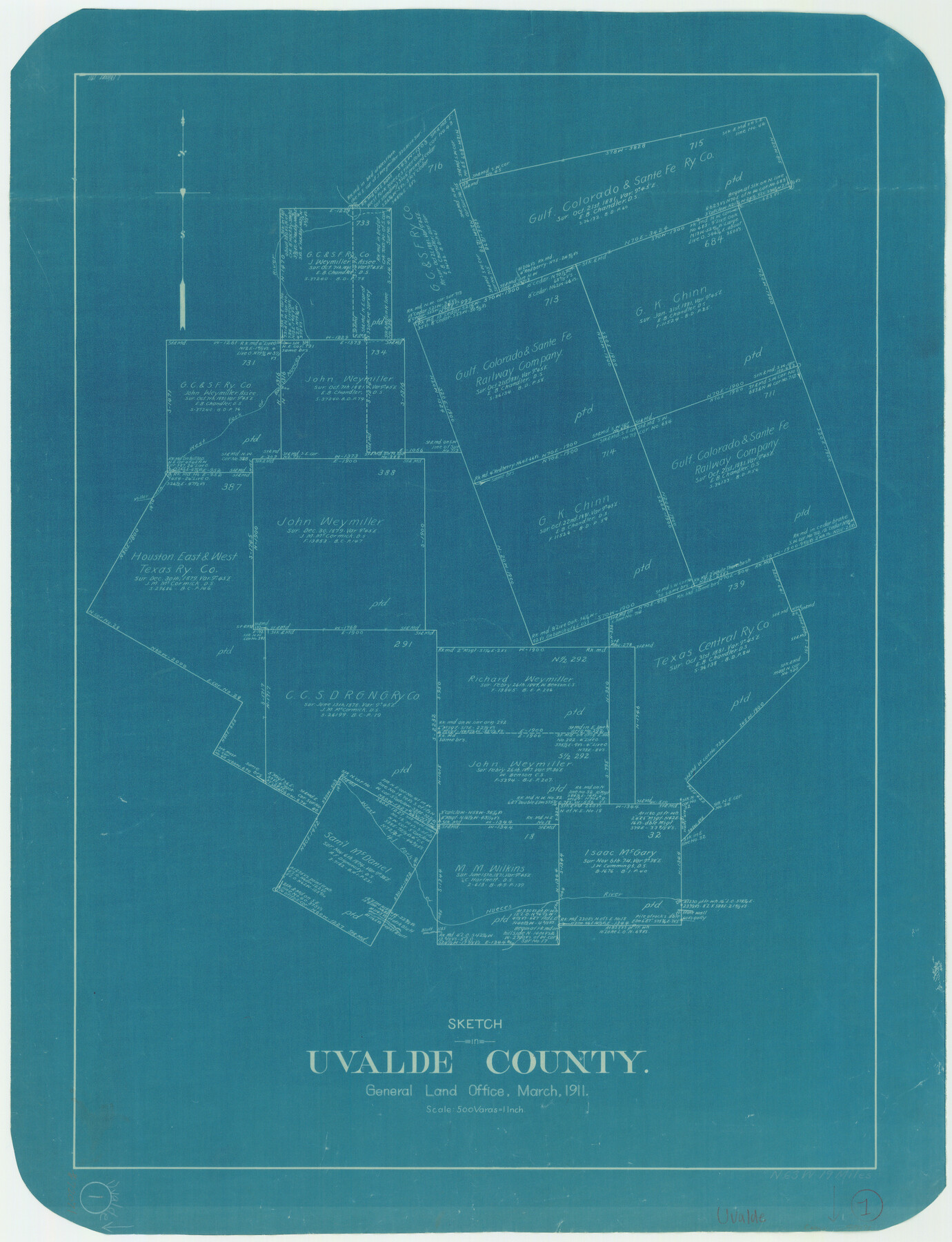
Uvalde County Working Sketch 1
-
Map/Doc
72071
-
Collection
General Map Collection
-
Object Dates
3/1911 (Creation Date)
-
Counties
Uvalde
-
Subjects
Surveying Working Sketch
-
Height x Width
27.3 x 21.0 inches
69.3 x 53.3 cm
-
Scale
1" = 500 varas
Part of: General Map Collection
Uvalde County Sketch File 25

Print $8.00
- Digital $50.00
Uvalde County Sketch File 25
1928
Size 14.5 x 8.8 inches
Map/Doc 39016
San Saba County Working Sketch 13

Print $20.00
- Digital $50.00
San Saba County Working Sketch 13
1995
Size 42.8 x 32.8 inches
Map/Doc 63801
Cass County Rolled Sketch 5B

Print $20.00
- Digital $50.00
Cass County Rolled Sketch 5B
1949
Size 23.5 x 16.4 inches
Map/Doc 5412
Amistad International Reservoir on Rio Grande 95a

Print $20.00
- Digital $50.00
Amistad International Reservoir on Rio Grande 95a
1950
Size 28.8 x 41.2 inches
Map/Doc 75526
Victoria County Rolled Sketch 8

Print $20.00
- Digital $50.00
Victoria County Rolled Sketch 8
Size 34.2 x 27.5 inches
Map/Doc 8153
Lubbock County Sketch File 15

Print $6.00
- Digital $50.00
Lubbock County Sketch File 15
1902
Size 11.2 x 8.8 inches
Map/Doc 30440
Van Zandt County Working Sketch 5

Print $20.00
- Digital $50.00
Van Zandt County Working Sketch 5
1940
Size 37.2 x 25.5 inches
Map/Doc 72254

Val Verde County Sketch File XX

Print $20.00
- Digital $50.00
Val Verde County Sketch File XX
Size 14.5 x 16.7 inches
Map/Doc 12546
Irion County Rolled Sketch 14

Print $20.00
- Digital $50.00
Irion County Rolled Sketch 14
1946
Size 25.3 x 21.9 inches
Map/Doc 6324
Fort Bend County Rolled Sketch 3

Print $20.00
- Digital $50.00
Fort Bend County Rolled Sketch 3
1958
Size 31.4 x 31.5 inches
Map/Doc 5893
DeWitt County Rolled Sketch 3A

Print $20.00
- Digital $50.00
DeWitt County Rolled Sketch 3A
1950
Size 25.3 x 35.2 inches
Map/Doc 5704
You may also like
Carson County Rolled Sketch 1

Print $20.00
- Digital $50.00
Carson County Rolled Sketch 1
Size 31.2 x 33.4 inches
Map/Doc 8580
Flight Mission No. CRK-5P, Frame 153, Refugio County

Print $20.00
- Digital $50.00
Flight Mission No. CRK-5P, Frame 153, Refugio County
1956
Size 18.4 x 22.3 inches
Map/Doc 86934
Ward County, Texas

Print $20.00
- Digital $50.00
Ward County, Texas
1888
Size 20.2 x 25.5 inches
Map/Doc 657
Runnels County Rolled Sketch 36

Print $40.00
- Digital $50.00
Runnels County Rolled Sketch 36
1950
Size 66.6 x 45.0 inches
Map/Doc 9869
Clay County Sketch File 16

Print $9.00
- Digital $50.00
Clay County Sketch File 16
1874
Size 8.3 x 7.9 inches
Map/Doc 18421
Runnels County Boundary File 1b

Print $24.00
- Digital $50.00
Runnels County Boundary File 1b
Size 15.7 x 8.3 inches
Map/Doc 58514
Map of the West Indies designed to accompany Smith's Geography for Schools

Print $20.00
- Digital $50.00
Map of the West Indies designed to accompany Smith's Geography for Schools
1850
Size 9.6 x 12.0 inches
Map/Doc 93893
Val Verde County Sketch File Z2

Print $31.00
- Digital $50.00
Val Verde County Sketch File Z2
1881
Size 16.7 x 10.7 inches
Map/Doc 39114
Terrell County Sketch File 22A

Print $20.00
- Digital $50.00
Terrell County Sketch File 22A
Size 21.7 x 11.4 inches
Map/Doc 12422
Lipscomb County

Print $20.00
- Digital $50.00
Lipscomb County
1889
Size 23.5 x 18.5 inches
Map/Doc 3817
Tyler County Rolled Sketch 11

Print $20.00
- Digital $50.00
Tyler County Rolled Sketch 11
Size 34.2 x 36.4 inches
Map/Doc 10033
Schleicher County Sketch File 39

Print $9.00
- Digital $50.00
Schleicher County Sketch File 39
1958
Size 14.8 x 9.4 inches
Map/Doc 36538