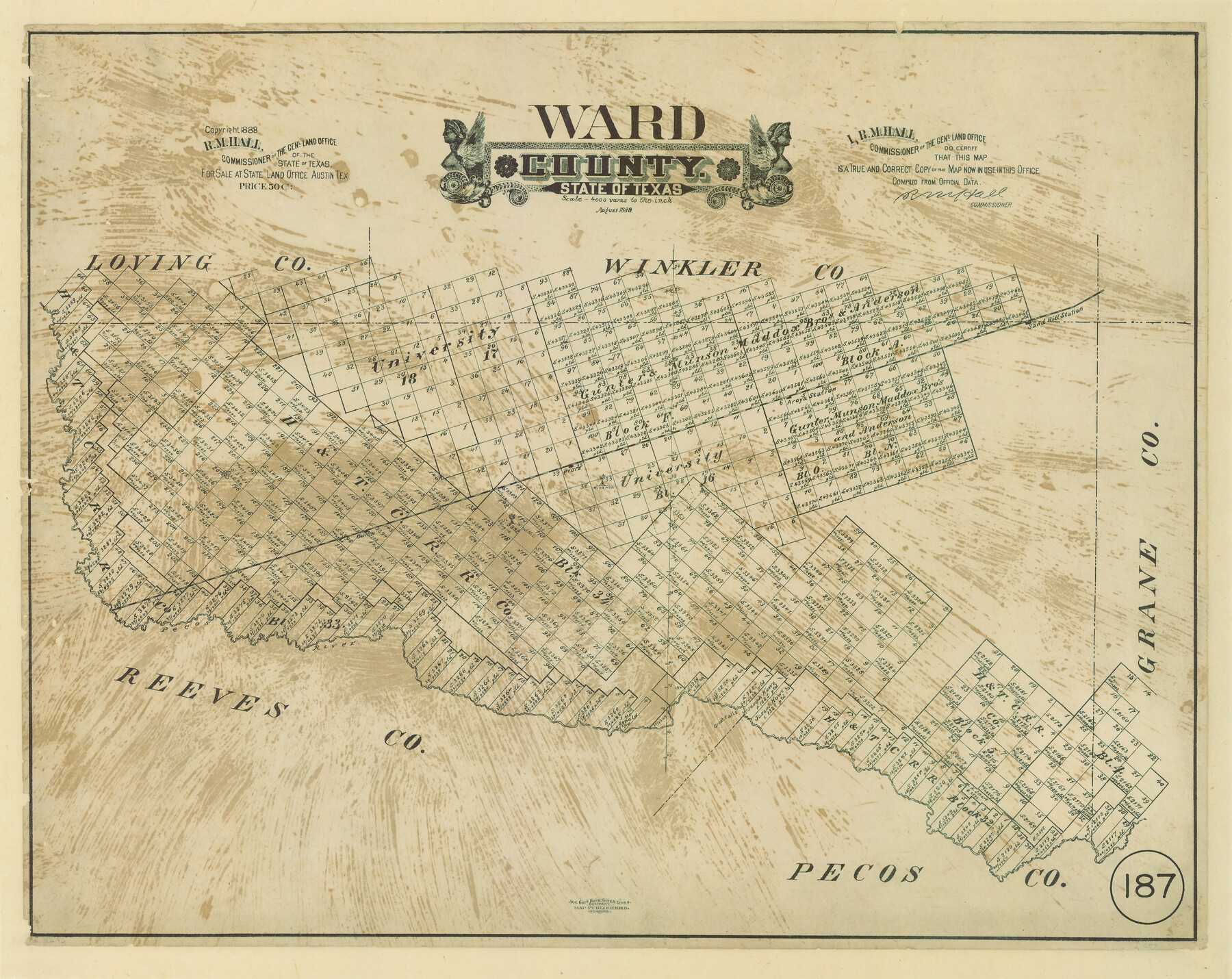
Ward County, Texas
-
Map/Doc
657
-
Collection
Maddox Collection
-
Object Dates
8/1889 (Creation Date)
1888 (Copyright Date)
-
People and Organizations
General Land Office (Publisher)
R.M. Hall (GLO Commissioner)
August Gast Bank Note & Lithograph Company (Lithographer)
-
Counties
Ward
-
Subjects
County
-
Height x Width
20.2 x 25.5 inches
51.3 x 64.8 cm
-
Medium
paper, etching/engraving/lithograph
-
Scale
1" = 4000 varas
-
Comments
Conservation funded in 2008 by Friends of the Texas General Land Office.
"Aug. Gast Bank Note & Litho. Company; Map Publishers, St. Louis" -
Features
Sand Hill Station
Pyote
Owlco
Great Falls
Pecos River
Part of: Maddox Collection
Littlefield and White's London Property

Print $20.00
- Digital $50.00
Littlefield and White's London Property
1916
Size 18.5 x 13.0 inches
Map/Doc 75796
McCulloch County, Texas

Print $20.00
- Digital $50.00
McCulloch County, Texas
1879
Size 24.6 x 18.0 inches
Map/Doc 573
Jefferson County, Texas

Print $20.00
- Digital $50.00
Jefferson County, Texas
1879
Size 21.7 x 18.8 inches
Map/Doc 521
[Surveying Sketch of John Knight, Champion Choate, A. M. Lejarza, et al in Hardin County, Texas - Exhibit "G"]
![75821, [Surveying Sketch of John Knight, Champion Choate, A. M. Lejarza, et al in Hardin County, Texas - Exhibit "G"], Maddox Collection](https://historictexasmaps.com/wmedia_w700/maps/75821.tif.jpg)
Print $20.00
- Digital $50.00
[Surveying Sketch of John Knight, Champion Choate, A. M. Lejarza, et al in Hardin County, Texas - Exhibit "G"]
Size 18.3 x 23.5 inches
Map/Doc 75821
Map of Bexar County, Texas

Print $20.00
- Digital $50.00
Map of Bexar County, Texas
1879
Size 25.1 x 29.7 inches
Map/Doc 530
[Sketch showing Wm. B. Jaques survey on Llano River]
![591, [Sketch showing Wm. B. Jaques survey on Llano River], Maddox Collection](https://historictexasmaps.com/wmedia_w700/maps/00591.tif.jpg)
Print $2.00
- Digital $50.00
[Sketch showing Wm. B. Jaques survey on Llano River]
Size 10.9 x 9.0 inches
Map/Doc 591
Camp County, Texas

Print $3.00
- Digital $50.00
Camp County, Texas
1879
Size 9.6 x 16.8 inches
Map/Doc 512
[Surveying Sketch of A. Forsythe Block B and R. M. Thomson Block M in Cottle County, Texas]
![523, [Surveying Sketch of A. Forsythe Block B and R. M. Thomson Block M in Cottle County, Texas], Maddox Collection](https://historictexasmaps.com/wmedia_w700/maps/523.tif.jpg)
Print $3.00
- Digital $50.00
[Surveying Sketch of A. Forsythe Block B and R. M. Thomson Block M in Cottle County, Texas]
1912
Size 11.0 x 15.8 inches
Map/Doc 523
Roberts County, Texas

Print $20.00
- Digital $50.00
Roberts County, Texas
1878
Size 19.2 x 18.5 inches
Map/Doc 749
Map of Lands in King County, Texas owned and leased by the Louisville Land and Cattle Company

Print $20.00
- Digital $50.00
Map of Lands in King County, Texas owned and leased by the Louisville Land and Cattle Company
Size 32.1 x 25.9 inches
Map/Doc 5070
Mitchell County, Texas

Print $20.00
- Digital $50.00
Mitchell County, Texas
1870
Size 22.7 x 18.0 inches
Map/Doc 741
Lands of Gunter & Munson and Maddox Bros. & Anderson, Tom Green Co. Tex.

Print $20.00
- Digital $50.00
Lands of Gunter & Munson and Maddox Bros. & Anderson, Tom Green Co. Tex.
Size 20.4 x 30.7 inches
Map/Doc 75787
You may also like
Liberty County Working Sketch 54

Print $20.00
- Digital $50.00
Liberty County Working Sketch 54
1962
Size 29.8 x 29.5 inches
Map/Doc 70514
Flight Mission No. BQR-13K, Frame 26, Brazoria County

Print $20.00
- Digital $50.00
Flight Mission No. BQR-13K, Frame 26, Brazoria County
1952
Size 18.7 x 22.4 inches
Map/Doc 84074
Potter County Rolled Sketch 11

Print $20.00
- Digital $50.00
Potter County Rolled Sketch 11
1986
Size 21.6 x 27.4 inches
Map/Doc 7324
DeWitt County Sketch File 7

Print $2.00
- Digital $50.00
DeWitt County Sketch File 7
1876
Size 11.3 x 9.0 inches
Map/Doc 20817
[H. & G. N. Block 12 and surveys and blocks south]
![91610, [H. & G. N. Block 12 and surveys and blocks south], Twichell Survey Records](https://historictexasmaps.com/wmedia_w700/maps/91610-1.tif.jpg)
Print $20.00
- Digital $50.00
[H. & G. N. Block 12 and surveys and blocks south]
1907
Size 27.9 x 24.0 inches
Map/Doc 91610
Bandera County Sketch File 24

Print $4.00
- Digital $50.00
Bandera County Sketch File 24
Size 9.3 x 8.3 inches
Map/Doc 14014
Brewster County Working Sketch 13

Print $20.00
- Digital $50.00
Brewster County Working Sketch 13
1928
Size 39.5 x 43.9 inches
Map/Doc 67546
Irion County Working Sketch 9

Print $20.00
- Digital $50.00
Irion County Working Sketch 9
1941
Size 13.6 x 17.2 inches
Map/Doc 66418
University of Texas System University Lands

Print $20.00
- Digital $50.00
University of Texas System University Lands
Size 17.9 x 23.3 inches
Map/Doc 93244
Pecos County Rolled Sketch 152

Print $20.00
- Digital $50.00
Pecos County Rolled Sketch 152
1960
Size 38.8 x 43.7 inches
Map/Doc 9736
Map of Newton Co.

Print $20.00
- Digital $50.00
Map of Newton Co.
1918
Size 46.4 x 39.4 inches
Map/Doc 81987
Lamb County Sketch File 14

Print $6.00
- Digital $50.00
Lamb County Sketch File 14
1914
Size 7.3 x 8.7 inches
Map/Doc 29374