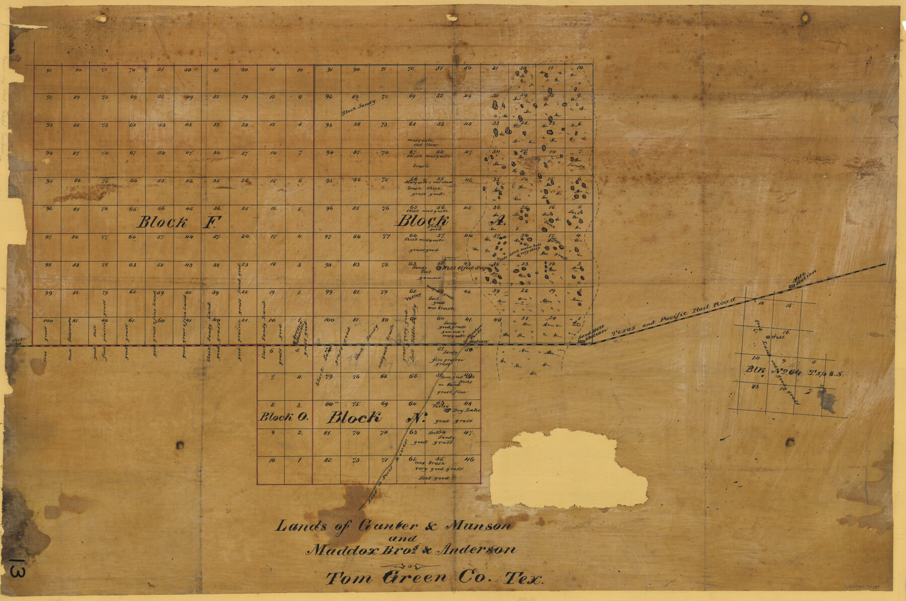
Lands of Gunter & Munson and Maddox Bros. & Anderson, Tom Green Co. Tex.
-
Map/Doc
75787
-
Collection
Maddox Collection
-
Counties
Tom Green Ward Winkler Ector Crane
-
Height x Width
20.4 x 30.7 inches
51.8 x 78.0 cm
-
Medium
linen, manuscript
-
Comments
Map is labeled Tom Green County, but the land is in present day Ward, Winkler, Ector and Crane counties. Sketch also describes terrain/vegetation in many areas.
-
Features
Metz Station
Sand Hill Station
T&P
Monehan Tanks Station
Road to Pecos River
Arroyo Station
Piote
Part of: Maddox Collection
Working Sketch in Cottle, Foard & Hardeman Counties

Print $20.00
- Digital $50.00
Working Sketch in Cottle, Foard & Hardeman Counties
1917
Size 26.9 x 28.0 inches
Map/Doc 4485
Moore County, Texas

Print $20.00
- Digital $50.00
Moore County, Texas
1888
Size 22.0 x 18.3 inches
Map/Doc 742
[Sketch of Pecos County School Land surveys along Pecos River in Val Verde County]
![369, [Sketch of Pecos County School Land surveys along Pecos River in Val Verde County], Maddox Collection](https://historictexasmaps.com/wmedia_w700/maps/0369-1.tif.jpg)
Print $2.00
- Digital $50.00
[Sketch of Pecos County School Land surveys along Pecos River in Val Verde County]
1882
Size 10.2 x 8.9 inches
Map/Doc 369
Map of Tyler County, Texas

Print $20.00
- Digital $50.00
Map of Tyler County, Texas
1882
Size 28.3 x 21.4 inches
Map/Doc 669
Palo Pinto County, Texas

Print $20.00
- Digital $50.00
Palo Pinto County, Texas
1879
Size 17.8 x 19.0 inches
Map/Doc 529
Plat of Surveys in Hidalgo Co.

Print $20.00
- Digital $50.00
Plat of Surveys in Hidalgo Co.
Size 18.2 x 9.3 inches
Map/Doc 405
Resurvey of H.L. Upshur's April 23, 1853 meanders of the Colorado River from the NE corner of Isaac Decker league to the Congress Avenue Bridge

Print $20.00
- Digital $50.00
Resurvey of H.L. Upshur's April 23, 1853 meanders of the Colorado River from the NE corner of Isaac Decker league to the Congress Avenue Bridge
1915
Size 24.0 x 16.3 inches
Map/Doc 75773
Map of Block 1, H. & G. N. R. R. Co., Dickens and Kent Counties Texas

Print $20.00
- Digital $50.00
Map of Block 1, H. & G. N. R. R. Co., Dickens and Kent Counties Texas
1908
Size 32.0 x 24.2 inches
Map/Doc 10780
[Sketch of surveys between Miguel Perez and Francisco Antonio Villareal grants, Starr County]
![5074, [Sketch of surveys between Miguel Perez and Francisco Antonio Villareal grants, Starr County], Maddox Collection](https://historictexasmaps.com/wmedia_w700/maps/5074.tif.jpg)
Print $3.00
- Digital $50.00
[Sketch of surveys between Miguel Perez and Francisco Antonio Villareal grants, Starr County]
1914
Size 16.7 x 10.6 inches
Map/Doc 5074
Loving County, Texas

Print $20.00
- Digital $50.00
Loving County, Texas
1889
Size 18.8 x 23.8 inches
Map/Doc 638
[Wm. Lewis No. 254 and Surrounding Surveys, Aransas County, Texas]
![82557, [Wm. Lewis No. 254 and Surrounding Surveys, Aransas County, Texas], Maddox Collection](https://historictexasmaps.com/wmedia_w700/maps/82557.tif.jpg)
Print $20.00
- Digital $50.00
[Wm. Lewis No. 254 and Surrounding Surveys, Aransas County, Texas]
Size 18.8 x 35.2 inches
Map/Doc 82557
Rough sketch showing survey made for L.T. Eck Block 14 and part of Block 13, Fairview Park, South Austin, Texas

Print $2.00
- Digital $50.00
Rough sketch showing survey made for L.T. Eck Block 14 and part of Block 13, Fairview Park, South Austin, Texas
1914
Size 9.0 x 14.4 inches
Map/Doc 467
You may also like
Texas, Matagorda Bay, Vicinity of Carancahua Bay

Print $40.00
- Digital $50.00
Texas, Matagorda Bay, Vicinity of Carancahua Bay
1933
Size 30.3 x 48.2 inches
Map/Doc 69989
Burnet County Sketch File 27b

Print $7.00
- Digital $50.00
Burnet County Sketch File 27b
1876
Size 10.3 x 8.1 inches
Map/Doc 16737
Part of original sketch of Block "H" W. & N. W. Ry. Co. Cottle County

Print $20.00
- Digital $50.00
Part of original sketch of Block "H" W. & N. W. Ry. Co. Cottle County
Size 13.7 x 14.6 inches
Map/Doc 10776
County and Railroad Map of Texas

Print $20.00
- Digital $50.00
County and Railroad Map of Texas
1876
Size 17.0 x 16.0 inches
Map/Doc 93624
Panola County Sketch File 13

Print $4.00
- Digital $50.00
Panola County Sketch File 13
1850
Size 14.1 x 7.8 inches
Map/Doc 33470
Throckmorton County Rolled Sketch 5A

Print $20.00
- Digital $50.00
Throckmorton County Rolled Sketch 5A
2001
Size 25.2 x 36.0 inches
Map/Doc 76406
Galveston Bay Entrance - Galveston and Texas City Harbors

Print $40.00
- Digital $50.00
Galveston Bay Entrance - Galveston and Texas City Harbors
1982
Size 37.0 x 53.3 inches
Map/Doc 69865
Terrell County Sketch File 30

Print $4.00
- Digital $50.00
Terrell County Sketch File 30
1940
Size 11.2 x 8.8 inches
Map/Doc 37979
Map of McCulloch County

Print $20.00
- Digital $50.00
Map of McCulloch County
1874
Size 26.7 x 20.7 inches
Map/Doc 3857
Hudspeth County Sketch File AQ1

Print $4.00
- Digital $50.00
Hudspeth County Sketch File AQ1
1902
Size 10.9 x 8.7 inches
Map/Doc 26922
Fractional Township No. 9 South Range No. 10 East of the Indian Meridian, Indian Territory

Print $20.00
- Digital $50.00
Fractional Township No. 9 South Range No. 10 East of the Indian Meridian, Indian Territory
1898
Size 19.3 x 24.3 inches
Map/Doc 75219
Flight Mission No. BRA-16M, Frame 56, Jefferson County

Print $20.00
- Digital $50.00
Flight Mission No. BRA-16M, Frame 56, Jefferson County
1953
Size 18.6 x 22.5 inches
Map/Doc 85673