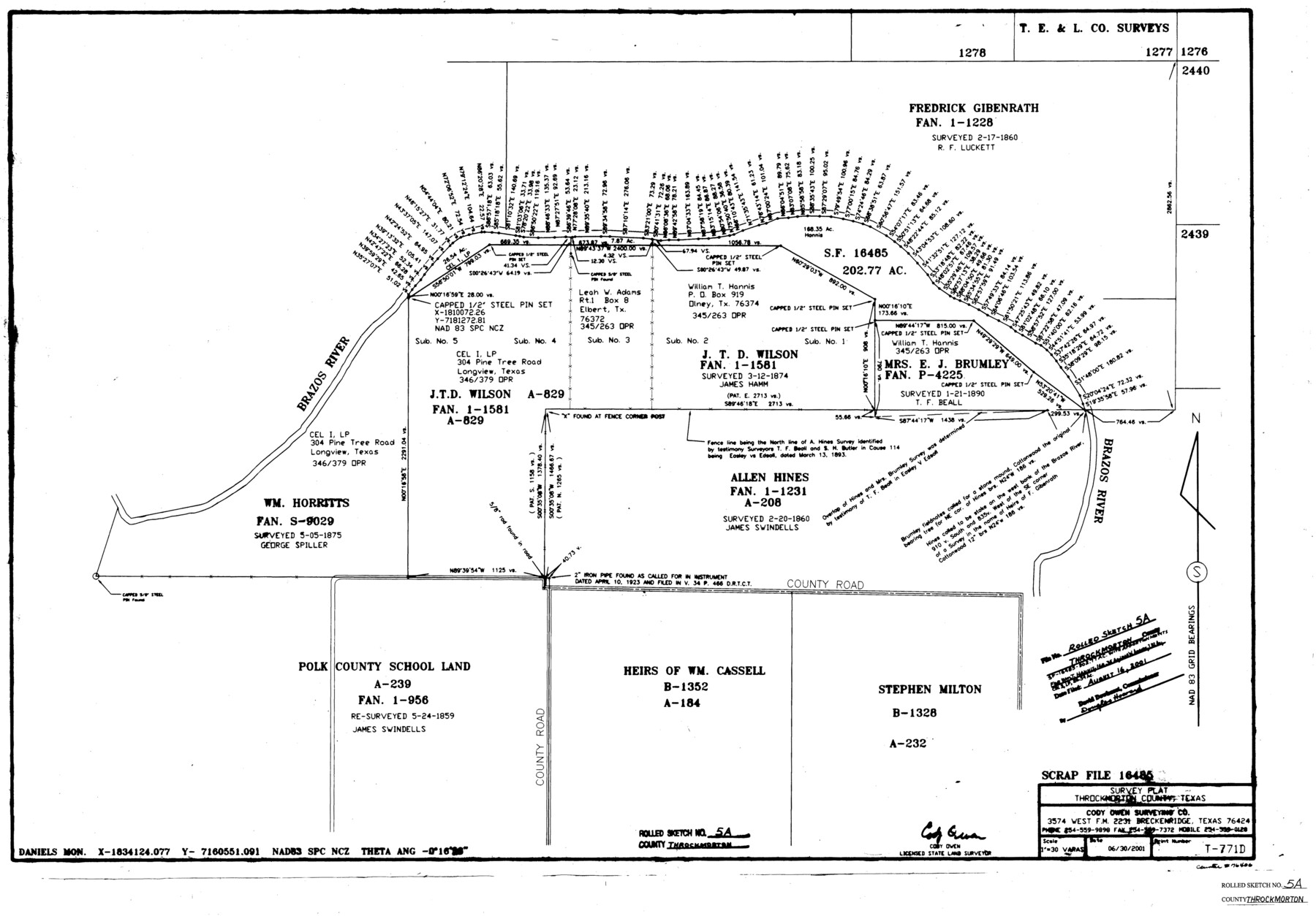
Throckmorton County Rolled Sketch 5A
[Survey plat - SF-16485]
-
Map/Doc
76406
-
Collection
General Map Collection
-
Object Dates
2001/6/30 (Creation Date)
2001/8/16 (File Date)
-
People and Organizations
Cody Owen (Surveyor/Engineer)
-
Counties
Throckmorton
-
Subjects
Surveying Rolled Sketch
-
Height x Width
25.2 x 36.0 inches
64.0 x 91.4 cm
-
Medium
mylar, print
-
Scale
1" = 30 varas
Part of: General Map Collection
Foard County Sketch File 33

Print $26.00
- Digital $50.00
Foard County Sketch File 33
1958
Size 11.4 x 8.9 inches
Map/Doc 22866
Flight Mission No. BRE-2P, Frame 47, Nueces County

Print $20.00
- Digital $50.00
Flight Mission No. BRE-2P, Frame 47, Nueces County
1956
Size 18.6 x 22.6 inches
Map/Doc 86749
Medina County Sketch File 13

Print $20.00
- Digital $50.00
Medina County Sketch File 13
Size 18.1 x 22.7 inches
Map/Doc 12069
Flight Mission No. DQO-8K, Frame 68, Galveston County

Print $20.00
- Digital $50.00
Flight Mission No. DQO-8K, Frame 68, Galveston County
1952
Size 17.3 x 19.5 inches
Map/Doc 85172
Orange County Working Sketch 5

Print $20.00
- Digital $50.00
Orange County Working Sketch 5
1917
Size 12.6 x 20.6 inches
Map/Doc 71337
Terrell County Working Sketch 81

Print $20.00
- Digital $50.00
Terrell County Working Sketch 81
1988
Size 28.4 x 36.0 inches
Map/Doc 69602
Galveston County Sketch File 1b

Print $6.00
- Digital $50.00
Galveston County Sketch File 1b
1845
Size 16.2 x 11.0 inches
Map/Doc 23347
Brewster County Rolled Sketch 27

Print $40.00
- Digital $50.00
Brewster County Rolled Sketch 27
Size 35.1 x 48.8 inches
Map/Doc 8474
Martin County

Print $20.00
- Digital $50.00
Martin County
1933
Size 45.5 x 40.3 inches
Map/Doc 95580

Navarro County Sketch File 16

Print $24.00
- Digital $50.00
Navarro County Sketch File 16
1902
Size 9.7 x 6.3 inches
Map/Doc 32330
Lynn County Rolled Sketch 14

Print $20.00
- Digital $50.00
Lynn County Rolled Sketch 14
1952
Size 35.4 x 35.3 inches
Map/Doc 9474
You may also like
Trinity County Sketch File 42

Print $60.00
- Digital $50.00
Trinity County Sketch File 42
1858
Size 28.0 x 37.6 inches
Map/Doc 10409
San Jacinto County Sketch File 12

Print $4.00
San Jacinto County Sketch File 12
1873
Size 9.7 x 8.2 inches
Map/Doc 35720
Maps & Lists Showing Prison Lands (Oil & Gas) Leased as of June 1955

Digital $50.00
Maps & Lists Showing Prison Lands (Oil & Gas) Leased as of June 1955
1934
Size 19.1 x 38.7 inches
Map/Doc 62878
Menard County Working Sketch 24

Print $20.00
- Digital $50.00
Menard County Working Sketch 24
1950
Size 38.1 x 22.6 inches
Map/Doc 70971
Tarrant County Boundary File 82

Print $22.00
- Digital $50.00
Tarrant County Boundary File 82
Size 8.9 x 7.0 inches
Map/Doc 59173

North East Corner of Lamar County

Print $3.00
- Digital $50.00
North East Corner of Lamar County
Size 10.7 x 15.4 inches
Map/Doc 291
Dawson County Rolled Sketch 7

Print $20.00
- Digital $50.00
Dawson County Rolled Sketch 7
Size 18.5 x 39.3 inches
Map/Doc 5692
Flight Mission No. DQO-3K, Frame 41, Galveston County

Print $20.00
- Digital $50.00
Flight Mission No. DQO-3K, Frame 41, Galveston County
1952
Size 18.7 x 22.5 inches
Map/Doc 85082
Maps of Gulf Intracoastal Waterway, Texas - Sabine River to the Rio Grande and connecting waterways including ship channels

Print $20.00
- Digital $50.00
Maps of Gulf Intracoastal Waterway, Texas - Sabine River to the Rio Grande and connecting waterways including ship channels
1966
Size 14.6 x 22.2 inches
Map/Doc 61939
Hudspeth County Sketch File 11

Print $14.00
- Digital $50.00
Hudspeth County Sketch File 11
Size 14.5 x 8.9 inches
Map/Doc 26903
Coast Chart No. 106, Galveston Bay to Oyster Bay, Texas

Print $20.00
Coast Chart No. 106, Galveston Bay to Oyster Bay, Texas
1858
Size 32.4 x 40.7 inches
Map/Doc 76252