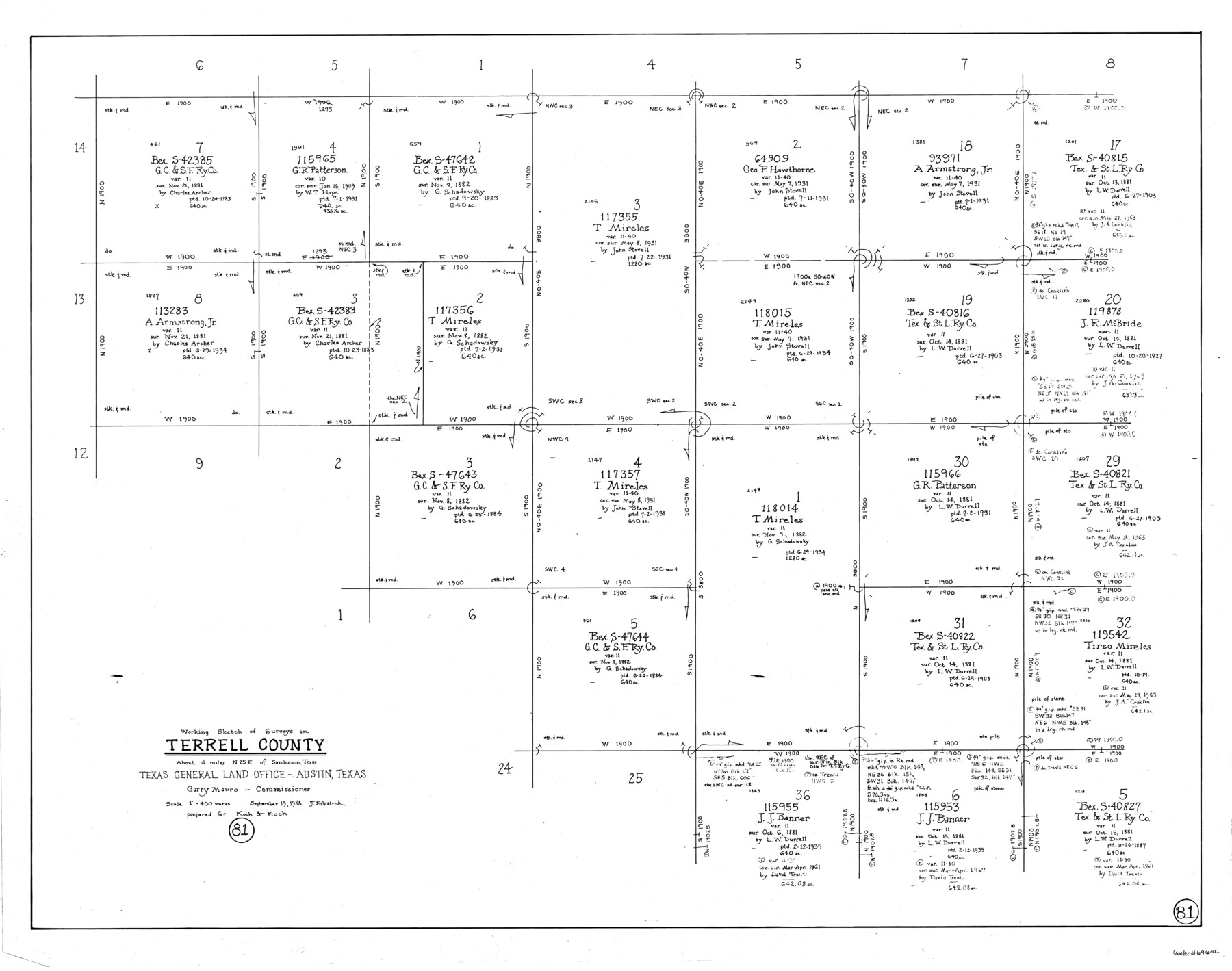
Terrell County Working Sketch 81
-
Map/Doc
69602
-
Collection
General Map Collection
-
Object Dates
9/19/1988 (Creation Date)
-
People and Organizations
Joan Kilpatrick (Draftsman)
-
Counties
Terrell
-
Subjects
Surveying Working Sketch
-
Height x Width
28.4 x 36.0 inches
72.1 x 91.4 cm
-
Scale
1" = 400 varas
Part of: General Map Collection
Loving County

Print $20.00
- Digital $50.00
Loving County
1932
Size 35.0 x 45.6 inches
Map/Doc 73225
Sherman County Boundary File 3

Print $55.00
- Digital $50.00
Sherman County Boundary File 3
Size 9.2 x 8.6 inches
Map/Doc 58773
[Galveston, Harrisburg & San Antonio Railroad from Cuero to Stockdale]
![64185, [Galveston, Harrisburg & San Antonio Railroad from Cuero to Stockdale], General Map Collection](https://historictexasmaps.com/wmedia_w700/maps/64185.tif.jpg)
Print $20.00
- Digital $50.00
[Galveston, Harrisburg & San Antonio Railroad from Cuero to Stockdale]
1906
Size 13.6 x 34.0 inches
Map/Doc 64185
McCulloch County Working Sketch 8

Print $20.00
- Digital $50.00
McCulloch County Working Sketch 8
1977
Size 22.5 x 19.8 inches
Map/Doc 70683
Jefferson County Sketch File 51

Print $10.00
- Digital $50.00
Jefferson County Sketch File 51
Size 10.0 x 6.7 inches
Map/Doc 28249
Flight Mission No. DIX-5P, Frame 113, Aransas County

Print $20.00
- Digital $50.00
Flight Mission No. DIX-5P, Frame 113, Aransas County
1956
Size 17.6 x 17.7 inches
Map/Doc 83792
Wood County Working Sketch 13

Print $20.00
- Digital $50.00
Wood County Working Sketch 13
1973
Size 23.1 x 20.2 inches
Map/Doc 62013
Guadalupe County Sketch File 5a

Print $12.00
- Digital $50.00
Guadalupe County Sketch File 5a
1869
Size 12.6 x 8.0 inches
Map/Doc 42205
Garza County Sketch File C

Print $22.00
- Digital $50.00
Garza County Sketch File C
1900
Size 18.0 x 10.8 inches
Map/Doc 24013
The Coast & Bays of Western Texas, St. Joseph's and Mustang Islands from actual survey, the remainder from county maps, etc.

Print $20.00
- Digital $50.00
The Coast & Bays of Western Texas, St. Joseph's and Mustang Islands from actual survey, the remainder from county maps, etc.
1857
Size 27.9 x 18.3 inches
Map/Doc 72766
[Sketch for Mineral Application 24072, San Jacinto River]
![65588, [Sketch for Mineral Application 24072, San Jacinto River], General Map Collection](https://historictexasmaps.com/wmedia_w700/maps/65588.tif.jpg)
Print $20.00
- Digital $50.00
[Sketch for Mineral Application 24072, San Jacinto River]
1929
Size 19.6 x 13.7 inches
Map/Doc 65588
Flight Mission No. CRC-2R, Frame 59, Chambers County

Print $20.00
- Digital $50.00
Flight Mission No. CRC-2R, Frame 59, Chambers County
1956
Size 18.7 x 22.5 inches
Map/Doc 84730
You may also like
Dimmit County Sketch File 1

Print $42.00
- Digital $50.00
Dimmit County Sketch File 1
1851
Size 8.8 x 7.5 inches
Map/Doc 21050
Flight Mission No. BRA-6M, Frame 151, Jefferson County

Print $20.00
- Digital $50.00
Flight Mission No. BRA-6M, Frame 151, Jefferson County
1953
Size 18.6 x 22.1 inches
Map/Doc 85452
Presidio County Rolled Sketch 117

Print $20.00
- Digital $50.00
Presidio County Rolled Sketch 117
Size 29.1 x 28.8 inches
Map/Doc 7392
General Highway Map, Falls County, Texas

Print $20.00
General Highway Map, Falls County, Texas
1940
Size 18.5 x 24.7 inches
Map/Doc 79088
Flight Mission No. CUG-3P, Frame 46, Kleberg County

Print $20.00
- Digital $50.00
Flight Mission No. CUG-3P, Frame 46, Kleberg County
1956
Size 18.5 x 22.2 inches
Map/Doc 86251

Angelina County Working Sketch 39

Print $20.00
- Digital $50.00
Angelina County Working Sketch 39
1959
Size 25.6 x 30.0 inches
Map/Doc 67122
Hopkins County Sketch File 1

Print $4.00
- Digital $50.00
Hopkins County Sketch File 1
1854
Size 5.2 x 10.2 inches
Map/Doc 26676
Oldham County Sketch File 4

Print $20.00
- Digital $50.00
Oldham County Sketch File 4
1883
Size 13.7 x 22.5 inches
Map/Doc 12111
El Paso County Working Sketch 13

Print $20.00
- Digital $50.00
El Paso County Working Sketch 13
1956
Size 33.4 x 39.7 inches
Map/Doc 69035
Harris County Sketch File 25

Print $8.00
- Digital $50.00
Harris County Sketch File 25
Size 9.0 x 11.8 inches
Map/Doc 25389
Flight Mission No. BRE-2P, Frame 18, Nueces County

Print $20.00
- Digital $50.00
Flight Mission No. BRE-2P, Frame 18, Nueces County
1956
Size 18.5 x 22.7 inches
Map/Doc 86727