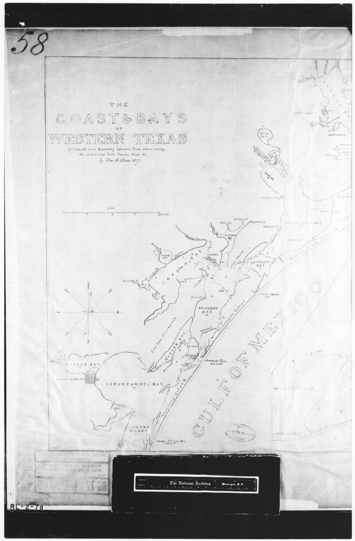
The Coast & Bays of Western Texas, St. Joseph's and Mustang Islands from actual survey, the remainder from county maps, etc.
RL-2-7d
-
Map/Doc
72766
-
Collection
General Map Collection
-
Object Dates
1857 (Creation Date)
-
People and Organizations
William H. Jones (Author)
-
Subjects
Gulf of Mexico
-
Height x Width
27.9 x 18.3 inches
70.9 x 46.5 cm
-
Comments
B/W photostat copy from National Archives in multiple pieces.
Part of: General Map Collection

Val Verde County Rolled Sketch 49

Print $20.00
- Digital $50.00
Val Verde County Rolled Sketch 49
Size 26.9 x 34.3 inches
Map/Doc 8120
Runnels County Boundary File 2a

Print $8.00
- Digital $50.00
Runnels County Boundary File 2a
Size 11.5 x 8.8 inches
Map/Doc 58526
[Map of San Antonio, Texas]
![93399, [Map of San Antonio, Texas], General Map Collection - 1](https://historictexasmaps.com/wmedia_w700/maps/93399.tif.jpg)
Print $20.00
- Digital $50.00
[Map of San Antonio, Texas]
1895
Size 29.4 x 34.5 inches
Map/Doc 93399
Carson County Boundary File 7

Print $64.00
- Digital $50.00
Carson County Boundary File 7
Size 9.3 x 6.9 inches
Map/Doc 51157
Montague County Sketch File 12

Print $4.00
- Digital $50.00
Montague County Sketch File 12
Size 11.4 x 8.2 inches
Map/Doc 31736
Houston County

Print $40.00
- Digital $50.00
Houston County
1944
Size 48.3 x 49.7 inches
Map/Doc 1859
Brewster County Rolled Sketch 82

Print $20.00
- Digital $50.00
Brewster County Rolled Sketch 82
1945
Size 20.3 x 23.3 inches
Map/Doc 5245
Henderson County Working Sketch 5

Print $20.00
- Digital $50.00
Henderson County Working Sketch 5
1918
Size 19.2 x 23.5 inches
Map/Doc 66138
Pecos County Rolled Sketch 173

Print $20.00
- Digital $50.00
Pecos County Rolled Sketch 173
Size 32.2 x 35.6 inches
Map/Doc 9751
Harris County Sketch File 15

Print $4.00
- Digital $50.00
Harris County Sketch File 15
Size 8.0 x 8.9 inches
Map/Doc 25359
Duval County Sketch File 4a

Print $6.00
- Digital $50.00
Duval County Sketch File 4a
1875
Size 13.3 x 10.8 inches
Map/Doc 21280
You may also like
Working Sketch in Hale County

Print $3.00
- Digital $50.00
Working Sketch in Hale County
Size 16.4 x 11.8 inches
Map/Doc 90746
Flight Mission No. DCL-6C, Frame 65, Kenedy County

Print $20.00
- Digital $50.00
Flight Mission No. DCL-6C, Frame 65, Kenedy County
1943
Size 18.5 x 22.3 inches
Map/Doc 85907
San Augustine County Sketch File 10

Print $4.00
San Augustine County Sketch File 10
Size 12.8 x 8.1 inches
Map/Doc 35652
Terrell County Rolled Sketch 45

Print $40.00
- Digital $50.00
Terrell County Rolled Sketch 45
1953
Size 33.5 x 51.7 inches
Map/Doc 9991
Garza County Rolled Sketch R-2

Print $40.00
- Digital $50.00
Garza County Rolled Sketch R-2
Size 36.0 x 50.2 inches
Map/Doc 9046
Polk County Working Sketch 35

Print $20.00
- Digital $50.00
Polk County Working Sketch 35
1961
Size 16.7 x 12.1 inches
Map/Doc 71652
Garza County Rolled Sketch 7

Print $11.00
- Digital $50.00
Garza County Rolled Sketch 7
1905
Size 10.0 x 15.4 inches
Map/Doc 45229
Nolan County Rolled Sketch 2

Print $20.00
- Digital $50.00
Nolan County Rolled Sketch 2
1956
Size 27.7 x 35.0 inches
Map/Doc 6860
Anderson County Sketch File 15a

Print $4.00
- Digital $50.00
Anderson County Sketch File 15a
1859
Size 14.5 x 8.0 inches
Map/Doc 12781

Erath County Working Sketch 3

Print $20.00
- Digital $50.00
Erath County Working Sketch 3
1919
Size 17.6 x 17.6 inches
Map/Doc 69084
Houston County

Print $40.00
- Digital $50.00
Houston County
1944
Size 50.3 x 50.3 inches
Map/Doc 73184