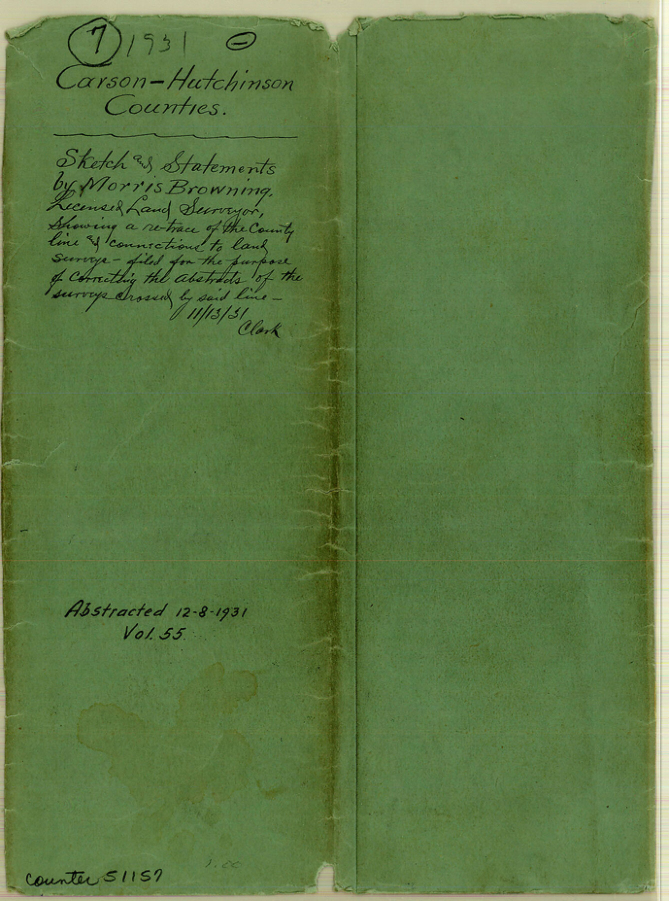
Carson County Boundary File 7
[Court Order; Surveyor's Statement regarding the Carson-Hutchinson County Bdry. Line; Sketch showing retrace of the County Line between Carson and Hutchinson Counties]
-
Map/Doc
51157
-
Collection
General Map Collection
-
Counties
Carson
-
Subjects
County Boundaries
-
Height x Width
9.3 x 6.9 inches
23.6 x 17.5 cm
Part of: General Map Collection
Hansford County Sketch File 4

Print $4.00
- Digital $50.00
Hansford County Sketch File 4
1917
Size 11.3 x 8.9 inches
Map/Doc 24952
Fractional Township No. 8 South Range No. 11 East of the Indian Meridian, Indian Territory

Print $20.00
- Digital $50.00
Fractional Township No. 8 South Range No. 11 East of the Indian Meridian, Indian Territory
1898
Size 19.2 x 24.3 inches
Map/Doc 75221
Polk County Working Sketch 6

Print $20.00
- Digital $50.00
Polk County Working Sketch 6
1933
Size 22.8 x 32.7 inches
Map/Doc 71621
Map of Liberty County Texas

Print $20.00
- Digital $50.00
Map of Liberty County Texas
1879
Size 25.4 x 25.3 inches
Map/Doc 42994
Topographical Map of the Rio Grande, Sheet No. 30

Print $20.00
- Digital $50.00
Topographical Map of the Rio Grande, Sheet No. 30
1912
Map/Doc 89554
Flight Mission No. BQR-12K, Frame 45, Brazoria County

Print $20.00
- Digital $50.00
Flight Mission No. BQR-12K, Frame 45, Brazoria County
1952
Size 18.8 x 22.5 inches
Map/Doc 84060
Aransas County NRC Article 33.136 Sketch 8

Print $22.00
- Digital $50.00
Aransas County NRC Article 33.136 Sketch 8
2007
Size 24.0 x 36.0 inches
Map/Doc 88800
Terrell County Working Sketch 84c

Print $20.00
- Digital $50.00
Terrell County Working Sketch 84c
1992
Size 18.2 x 31.3 inches
Map/Doc 69607
Terrell County Working Sketch 77

Print $20.00
- Digital $50.00
Terrell County Working Sketch 77
1983
Size 22.9 x 33.7 inches
Map/Doc 69598
Flight Mission No. DAG-21K, Frame 103, Matagorda County

Print $20.00
- Digital $50.00
Flight Mission No. DAG-21K, Frame 103, Matagorda County
1952
Size 18.7 x 22.3 inches
Map/Doc 86431
Taylor County Sketch File A

Print $2.00
- Digital $50.00
Taylor County Sketch File A
Size 8.8 x 11.3 inches
Map/Doc 37773
In the Supreme Court of the United States, The State of Oklahoma, Complainant vs. The State of Texas, Defendant, The United States of America, Intervener, Red River Valley, Texas and Oklahoma Between the 98th and 100th Meridians in Five Sheets, 1921

Print $40.00
- Digital $50.00
In the Supreme Court of the United States, The State of Oklahoma, Complainant vs. The State of Texas, Defendant, The United States of America, Intervener, Red River Valley, Texas and Oklahoma Between the 98th and 100th Meridians in Five Sheets, 1921
1921
Size 37.1 x 60.6 inches
Map/Doc 75278
You may also like
Amistad International Reservoir on Rio Grande 83

Print $20.00
- Digital $50.00
Amistad International Reservoir on Rio Grande 83
1949
Size 28.5 x 40.3 inches
Map/Doc 75512
Liberty County Working Sketch 8

Print $20.00
- Digital $50.00
Liberty County Working Sketch 8
1906
Size 42.4 x 33.1 inches
Map/Doc 70467
Terrell County Rolled Sketch W

Print $20.00
- Digital $50.00
Terrell County Rolled Sketch W
Size 15.4 x 14.3 inches
Map/Doc 7979
Northwest Part of Webb County

Print $40.00
- Digital $50.00
Northwest Part of Webb County
1984
Size 42.0 x 50.2 inches
Map/Doc 77454
Hunt County Boundary File 10a

Print $40.00
- Digital $50.00
Hunt County Boundary File 10a
Size 42.1 x 10.5 inches
Map/Doc 55262
[I. & G. N. RR. Co. Blk. 6, Blks M8, M9 and M10]
![90267, [I. & G. N. RR. Co. Blk. 6, Blks M8, M9 and M10], Twichell Survey Records](https://historictexasmaps.com/wmedia_w700/maps/90267-1.tif.jpg)
Print $20.00
- Digital $50.00
[I. & G. N. RR. Co. Blk. 6, Blks M8, M9 and M10]
Size 34.2 x 20.3 inches
Map/Doc 90267
Kinney County Working Sketch 3

Print $20.00
- Digital $50.00
Kinney County Working Sketch 3
Size 20.3 x 17.6 inches
Map/Doc 70185
Panola County Sketch File 1a

Print $4.00
- Digital $50.00
Panola County Sketch File 1a
1855
Size 12.7 x 7.9 inches
Map/Doc 33445
Bosque County Sketch File 11

Print $4.00
- Digital $50.00
Bosque County Sketch File 11
1863
Size 10.2 x 8.3 inches
Map/Doc 14759
Motley County Sketch File 37 (S)

Print $22.00
- Digital $50.00
Motley County Sketch File 37 (S)
Size 11.3 x 8.7 inches
Map/Doc 32222
Polk County Sketch File 32

Print $8.00
- Digital $50.00
Polk County Sketch File 32
1887
Size 12.8 x 8.0 inches
Map/Doc 34226
Parker County Working Sketch 8

Print $20.00
- Digital $50.00
Parker County Working Sketch 8
1956
Map/Doc 71458