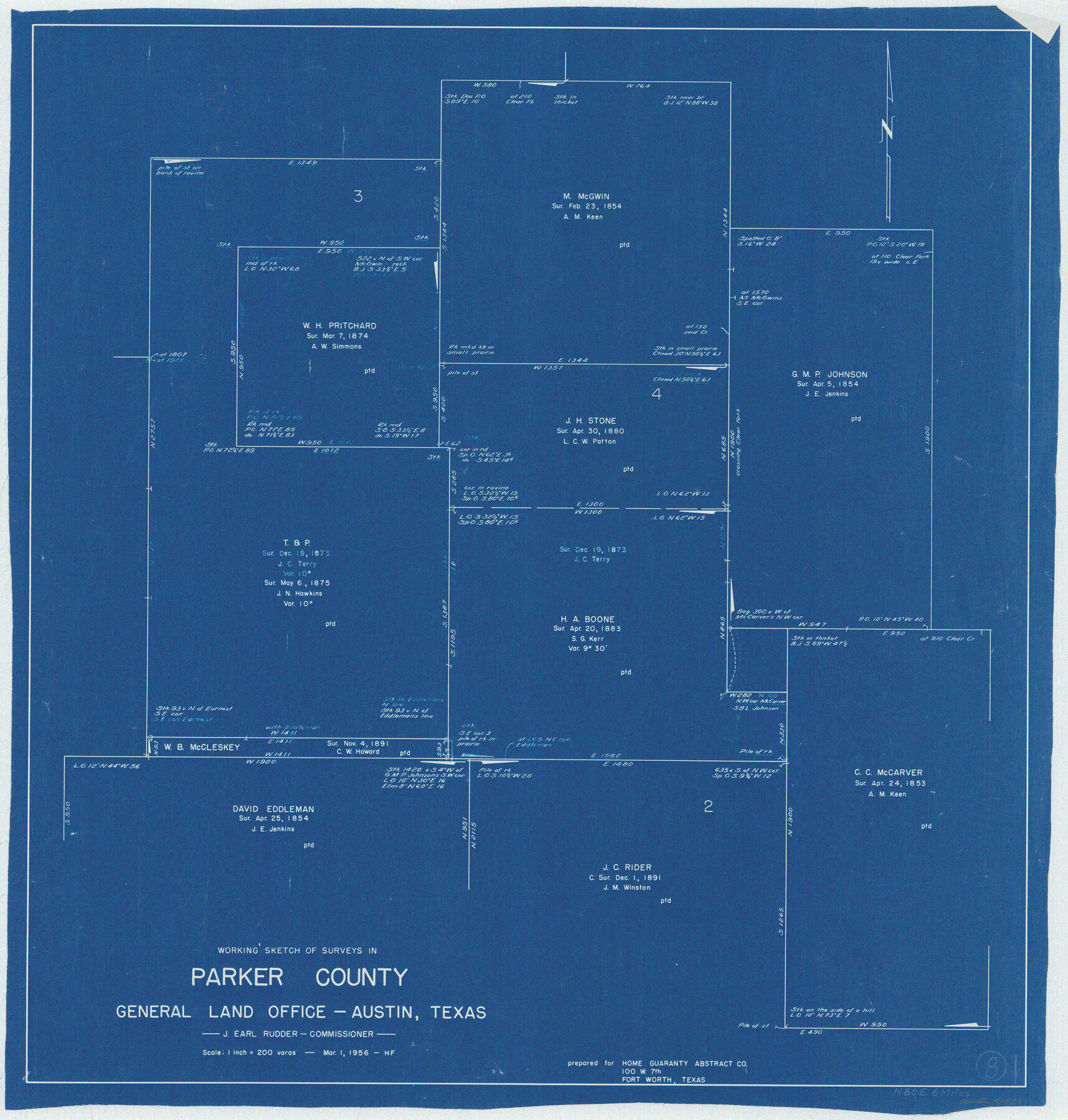
Parker County Working Sketch 8
-
Map/Doc
71458
-
Collection
General Map Collection
-
Counties
Parker
-
Subjects
Cadastral Surveying Working Sketch
-
Height x Width
26.3 x 25.1 inches
66.8 x 63.8 cm
Part of: General Map Collection
Jefferson County Sketch File 55
![28386, Jefferson County Sketch File 55, General Map Collection](https://historictexasmaps.com/wmedia_w700/pdf_converted_jpg/qi_pdf_thumbnail_12317.jpg)
Print $30.00
- Digital $50.00
Jefferson County Sketch File 55
1982
Size 11.1 x 8.5 inches
Map/Doc 28386
La Salle County Working Sketch 40
![70341, La Salle County Working Sketch 40, General Map Collection](https://historictexasmaps.com/wmedia_w700/maps/70341.tif.jpg)
Print $20.00
- Digital $50.00
La Salle County Working Sketch 40
Size 23.0 x 19.2 inches
Map/Doc 70341
Baylor County Sketch File 6a
![14132, Baylor County Sketch File 6a, General Map Collection](https://historictexasmaps.com/wmedia_w700/pdf_converted_jpg/qi_pdf_thumbnail_9280.jpg)
Print $6.00
- Digital $50.00
Baylor County Sketch File 6a
1887
Size 10.8 x 8.1 inches
Map/Doc 14132
Limestone County Working Sketch 11
![70561, Limestone County Working Sketch 11, General Map Collection](https://historictexasmaps.com/wmedia_w700/maps/70561.tif.jpg)
Print $20.00
- Digital $50.00
Limestone County Working Sketch 11
Size 36.1 x 33.9 inches
Map/Doc 70561
Webb County Working Sketch 57
![72423, Webb County Working Sketch 57, General Map Collection](https://historictexasmaps.com/wmedia_w700/maps/72423.tif.jpg)
Print $20.00
- Digital $50.00
Webb County Working Sketch 57
Size 24.9 x 38.0 inches
Map/Doc 72423
[Brown County]
![3337, [Brown County] , General Map Collection](https://historictexasmaps.com/wmedia_w700/maps/3337.tif.jpg)
Print $20.00
- Digital $50.00
[Brown County]
1863
Size 25.4 x 22.5 inches
Map/Doc 3337
Runnels County Sketch File 28
![35493, Runnels County Sketch File 28, General Map Collection](https://historictexasmaps.com/wmedia_w700/pdf_converted_jpg/qi_pdf_thumbnail_13949.jpg)
Print $6.00
Runnels County Sketch File 28
1949
Size 11.3 x 8.8 inches
Map/Doc 35493
[Aerial photograph from Carancahua Bend of Caney Creek to Cedar Lake]
![78640, [Aerial photograph from Carancahua Bend of Caney Creek to Cedar Lake], General Map Collection](https://historictexasmaps.com/wmedia_w700/maps/78640.tif.jpg)
Print $20.00
- Digital $50.00
[Aerial photograph from Carancahua Bend of Caney Creek to Cedar Lake]
1991
Size 24.4 x 30.3 inches
Map/Doc 78640
Kinney County Rolled Sketch 2
![6534, Kinney County Rolled Sketch 2, General Map Collection](https://historictexasmaps.com/wmedia_w700/maps/6534.tif.jpg)
Print $20.00
- Digital $50.00
Kinney County Rolled Sketch 2
Size 24.5 x 36.2 inches
Map/Doc 6534
Flight Mission No. DCL-5C, Frame 30, Kenedy County
![85842, Flight Mission No. DCL-5C, Frame 30, Kenedy County, General Map Collection](https://historictexasmaps.com/wmedia_w700/pdf_converted_jpg/qi_pdf_thumbnail_33032.jpg)
Print $20.00
- Digital $50.00
Flight Mission No. DCL-5C, Frame 30, Kenedy County
1943
Size 18.6 x 22.3 inches
Map/Doc 85842
Brazoria County Boundary File 2
![50704, Brazoria County Boundary File 2, General Map Collection](https://historictexasmaps.com/wmedia_w700/pdf_converted_jpg/qi_pdf_thumbnail_15678.jpg)
Print $140.00
- Digital $50.00
Brazoria County Boundary File 2
Size 12.8 x 9.8 inches
Map/Doc 50704
Dimmit County Working Sketch 49
![68710, Dimmit County Working Sketch 49, General Map Collection](https://historictexasmaps.com/wmedia_w700/maps/68710.tif.jpg)
Print $40.00
- Digital $50.00
Dimmit County Working Sketch 49
Size 78.8 x 44.7 inches
Map/Doc 68710
You may also like
Harris County Sketch File 90
![25596, Harris County Sketch File 90, General Map Collection](https://historictexasmaps.com/wmedia_w700/pdf_converted_jpg/qi_pdf_thumbnail_11762.jpg)
Print $46.00
- Digital $50.00
Harris County Sketch File 90
1967
Size 12.2 x 14.4 inches
Map/Doc 25596
Red River County Working Sketch 21
![72004, Red River County Working Sketch 21, General Map Collection](https://historictexasmaps.com/wmedia_w700/maps/72004.tif.jpg)
Print $6.00
- Digital $50.00
Red River County Working Sketch 21
Size 33.2 x 18.5 inches
Map/Doc 72004
Navarro County Working Sketch 7
![71237, Navarro County Working Sketch 7, General Map Collection](https://historictexasmaps.com/wmedia_w700/maps/71237.tif.jpg)
Print $20.00
- Digital $50.00
Navarro County Working Sketch 7
Size 28.2 x 23.4 inches
Map/Doc 71237
Culberson County Rolled Sketch 51
![5670, Culberson County Rolled Sketch 51, General Map Collection](https://historictexasmaps.com/wmedia_w700/maps/5670.tif.jpg)
Print $20.00
- Digital $50.00
Culberson County Rolled Sketch 51
1966
Size 35.2 x 27.0 inches
Map/Doc 5670
Hudspeth County Rolled Sketch 23
![9207, Hudspeth County Rolled Sketch 23, General Map Collection](https://historictexasmaps.com/wmedia_w700/maps/9207.tif.jpg)
Print $40.00
- Digital $50.00
Hudspeth County Rolled Sketch 23
Size 43.7 x 70.3 inches
Map/Doc 9207
Flight Mission No. BRE-2P, Frame 94, Nueces County
![86779, Flight Mission No. BRE-2P, Frame 94, Nueces County, General Map Collection](https://historictexasmaps.com/wmedia_w700/pdf_converted_jpg/qi_pdf_thumbnail_33916.jpg)
Print $20.00
- Digital $50.00
Flight Mission No. BRE-2P, Frame 94, Nueces County
1956
Size 18.6 x 22.3 inches
Map/Doc 86779
Jeff Davis County Working Sketch 6
![66501, Jeff Davis County Working Sketch 6, General Map Collection](https://historictexasmaps.com/wmedia_w700/maps/66501.tif.jpg)
Print $20.00
- Digital $50.00
Jeff Davis County Working Sketch 6
Size 43.5 x 39.8 inches
Map/Doc 66501
Hardeman County Working Sketch 10
![63391, Hardeman County Working Sketch 10, General Map Collection](https://historictexasmaps.com/wmedia_w700/maps/63391.tif.jpg)
Print $20.00
- Digital $50.00
Hardeman County Working Sketch 10
Size 21.9 x 29.9 inches
Map/Doc 63391
Map of part of the island of Hawaii Sandwich Islands shewing the craters and eruption of May and June 1840 by the U.S. Ex. Ex.
![94061, Map of part of the island of Hawaii Sandwich Islands shewing the craters and eruption of May and June 1840 by the U.S. Ex. Ex., Rees-Jones Digital Map Collection](https://historictexasmaps.com/wmedia_w700/maps/94061.tif.jpg)
Print $20.00
- Digital $50.00
Map of part of the island of Hawaii Sandwich Islands shewing the craters and eruption of May and June 1840 by the U.S. Ex. Ex.
1841
Size 18.4 x 25.9 inches
Map/Doc 94061
Sketch Showing Original Corners Affecting Block I and Adjacent Surveys from Actual Connections by W. D. Twichell
![90285, Sketch Showing Original Corners Affecting Block I and Adjacent Surveys from Actual Connections by W. D. Twichell, Twichell Survey Records](https://historictexasmaps.com/wmedia_w700/maps/90285-1.tif.jpg)
Print $20.00
- Digital $50.00
Sketch Showing Original Corners Affecting Block I and Adjacent Surveys from Actual Connections by W. D. Twichell
Size 23.9 x 24.2 inches
Map/Doc 90285
Henderson County Working Sketch 8
![66141, Henderson County Working Sketch 8, General Map Collection](https://historictexasmaps.com/wmedia_w700/maps/66141.tif.jpg)
Print $20.00
- Digital $50.00
Henderson County Working Sketch 8
Size 15.9 x 16.1 inches
Map/Doc 66141