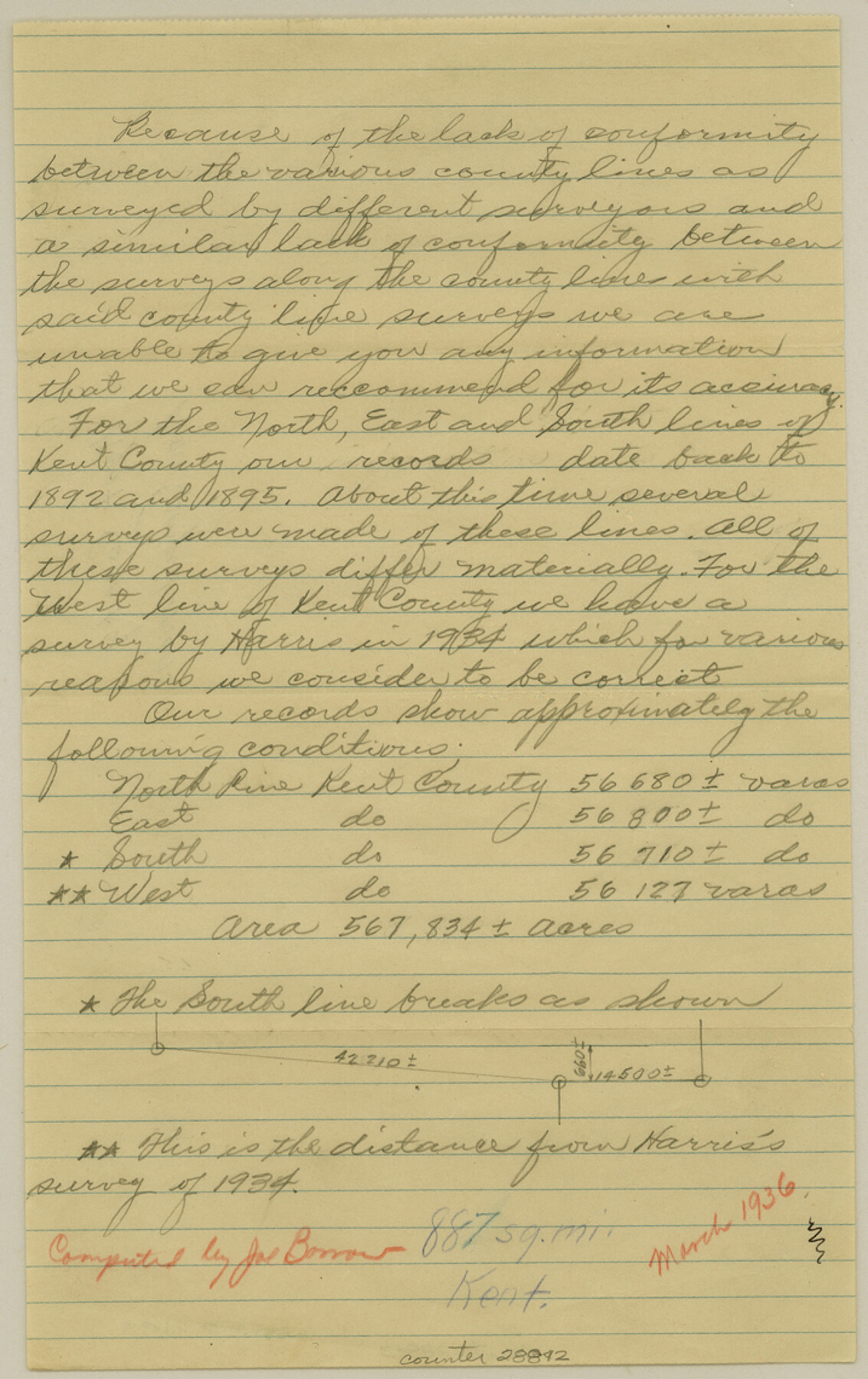
Kent County Sketch File 15
[Computations of area of Kent County showing 887 square miles]
-
Map/Doc
28842
-
Collection
General Map Collection
-
Object Dates
3/11/1936 (Creation Date)
3/11/1936 (File Date)
1934 (Survey Date)
-
People and Organizations
Harris (Surveyor/Engineer)
J.O. Barrow (Surveyor/Engineer)
-
Counties
Kent
-
Subjects
Surveying Sketch File
-
Height x Width
11.4 x 7.2 inches
29.0 x 18.3 cm
-
Medium
paper, manuscript
Part of: General Map Collection
Terry County Sketch File 4

Print $20.00
- Digital $50.00
Terry County Sketch File 4
1913
Size 14.4 x 8.7 inches
Map/Doc 38016
Dickens County Boundary File 1

Print $6.00
- Digital $50.00
Dickens County Boundary File 1
Size 8.8 x 3.7 inches
Map/Doc 52530
Robertson County Working Sketch 7

Print $20.00
- Digital $50.00
Robertson County Working Sketch 7
1983
Size 36.4 x 38.5 inches
Map/Doc 63580
Flight Mission No. CRC-2R, Frame 188, Chambers County

Print $20.00
- Digital $50.00
Flight Mission No. CRC-2R, Frame 188, Chambers County
1956
Size 18.5 x 22.3 inches
Map/Doc 84766
Map of Chicago, Rock Island & Texas Railway through Wise and Tarrant County, Texas

Print $40.00
- Digital $50.00
Map of Chicago, Rock Island & Texas Railway through Wise and Tarrant County, Texas
1893
Size 19.4 x 121.0 inches
Map/Doc 64428
[Surveys on the Rio Frio]
![267, [Surveys on the Rio Frio], General Map Collection](https://historictexasmaps.com/wmedia_w700/maps/267.tif.jpg)
Print $2.00
- Digital $50.00
[Surveys on the Rio Frio]
1847
Size 11.8 x 7.3 inches
Map/Doc 267
Hartley County

Print $40.00
- Digital $50.00
Hartley County
1925
Size 41.9 x 52.1 inches
Map/Doc 1851
Gaines County Rolled Sketch 33

Print $20.00
- Digital $50.00
Gaines County Rolled Sketch 33
1995
Size 17.4 x 18.2 inches
Map/Doc 76413
Ward County Working Sketch 49

Print $40.00
- Digital $50.00
Ward County Working Sketch 49
1974
Size 54.8 x 37.1 inches
Map/Doc 72355
Hale County Boundary File 4

Print $40.00
- Digital $50.00
Hale County Boundary File 4
Size 8.8 x 4.2 inches
Map/Doc 54048
Gaines County Working Sketch 2

Print $20.00
- Digital $50.00
Gaines County Working Sketch 2
1939
Size 29.4 x 39.9 inches
Map/Doc 69302
Pecos County Sketch File 64

Print $12.00
- Digital $50.00
Pecos County Sketch File 64
1919
Size 11.1 x 8.8 inches
Map/Doc 33818
You may also like
Liberty County Working Sketch 55

Print $20.00
- Digital $50.00
Liberty County Working Sketch 55
1962
Size 30.4 x 31.4 inches
Map/Doc 70515
Palo Pinto County Sketch File B

Print $20.00
- Digital $50.00
Palo Pinto County Sketch File B
Size 45.3 x 45.5 inches
Map/Doc 10566
Jeff Davis County Sketch File 40

Print $40.00
- Digital $50.00
Jeff Davis County Sketch File 40
1959
Size 12.8 x 18.2 inches
Map/Doc 28062
Parker County Working Sketch 22

Print $20.00
- Digital $50.00
Parker County Working Sketch 22
2007
Map/Doc 88607
Subdivision Map of Childress County School Land situated in Bailey and Cochran Counties, Tex.

Print $20.00
- Digital $50.00
Subdivision Map of Childress County School Land situated in Bailey and Cochran Counties, Tex.
Size 22.8 x 26.2 inches
Map/Doc 90200
Cooke County Boundary File 2a

Print $8.00
- Digital $50.00
Cooke County Boundary File 2a
Size 12.2 x 7.7 inches
Map/Doc 51849
Flight Mission No. DQO-7K, Frame 77, Galveston County

Print $20.00
- Digital $50.00
Flight Mission No. DQO-7K, Frame 77, Galveston County
1952
Size 18.9 x 22.6 inches
Map/Doc 85104
Floyd County Sketch File A

Print $4.00
- Digital $50.00
Floyd County Sketch File A
1893
Size 9.0 x 11.3 inches
Map/Doc 22684
[I. & G. N. Block 1]
![91588, [I. & G. N. Block 1], Twichell Survey Records](https://historictexasmaps.com/wmedia_w700/maps/91588-1.tif.jpg)
Print $20.00
- Digital $50.00
[I. & G. N. Block 1]
Size 11.8 x 18.6 inches
Map/Doc 91588
Mapa de los Estados Unidos de Méjico, Segun lo organizado y definido por las varias actas del Congreso de dicha Republica: y construido por las mejores autoridades

Print $20.00
Mapa de los Estados Unidos de Méjico, Segun lo organizado y definido por las varias actas del Congreso de dicha Republica: y construido por las mejores autoridades
1828
Size 29.3 x 41.6 inches
Map/Doc 76217
Harris County Working Sketch 85

Print $20.00
- Digital $50.00
Harris County Working Sketch 85
1971
Size 41.5 x 44.0 inches
Map/Doc 65977
Flight Mission No. CRC-5R, Frame 37, Chambers County

Print $20.00
- Digital $50.00
Flight Mission No. CRC-5R, Frame 37, Chambers County
1956
Size 18.6 x 22.4 inches
Map/Doc 84956