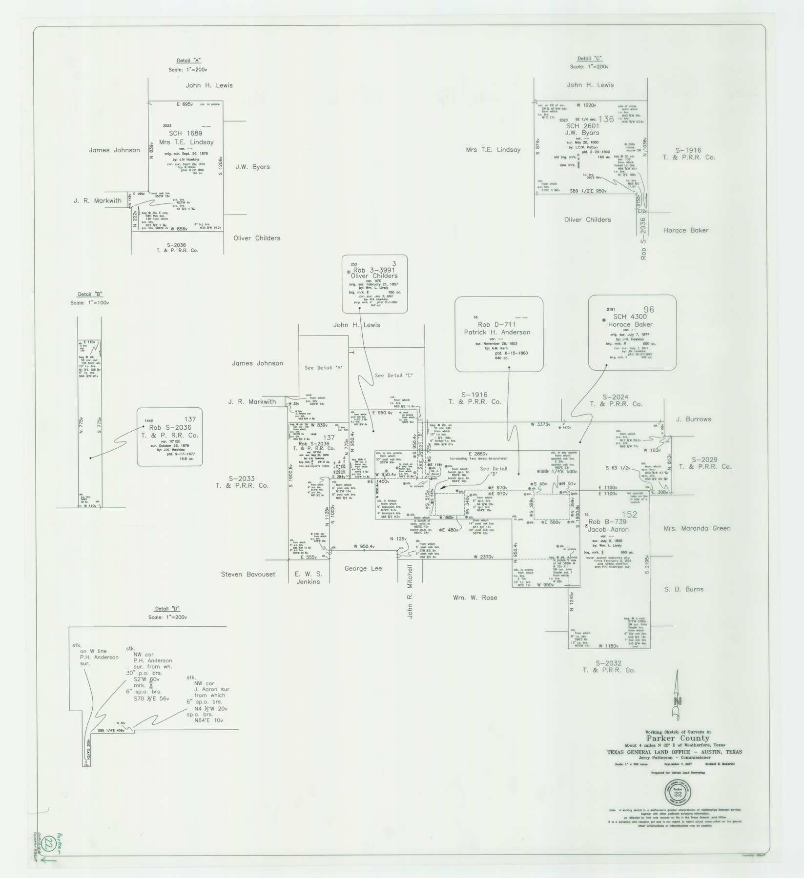
Parker County Working Sketch 22
-
Map/Doc
88607
-
Collection
General Map Collection
-
Object Dates
9/7/2007 (Creation Date)
-
People and Organizations
Jerry E. Patterson (GLO Commissioner)
Michael R. Mokarzel (Draftsman)
-
Counties
Parker
-
Subjects
Surveying Working Sketch
-
Scale
1" = 300 varas
Part of: General Map Collection
Kenedy County Rolled Sketch 9

Print $20.00
- Digital $50.00
Kenedy County Rolled Sketch 9
Size 27.1 x 41.7 inches
Map/Doc 6469
Lipscomb County Boundary File 7

Print $4.00
- Digital $50.00
Lipscomb County Boundary File 7
Size 6.6 x 8.1 inches
Map/Doc 56331
Bandera County Working Sketch 41

Print $20.00
- Digital $50.00
Bandera County Working Sketch 41
1977
Size 31.3 x 37.7 inches
Map/Doc 67637
Hammond's continental map of the United States

Digital $50.00
Hammond's continental map of the United States
1940
Size 33.2 x 50.2 inches
Map/Doc 3118
Garza County Working Sketch 7

Print $20.00
- Digital $50.00
Garza County Working Sketch 7
1949
Size 26.0 x 28.2 inches
Map/Doc 63154
Baylor County Working Sketch 5

Print $20.00
- Digital $50.00
Baylor County Working Sketch 5
1940
Size 11.9 x 30.4 inches
Map/Doc 67290
Hudspeth County Sketch File 44

Print $6.00
- Digital $50.00
Hudspeth County Sketch File 44
1886
Size 11.0 x 8.5 inches
Map/Doc 27027
Webb County Rolled Sketch 63

Print $20.00
- Digital $50.00
Webb County Rolled Sketch 63
1948
Size 39.4 x 37.0 inches
Map/Doc 10129
Uvalde County Boundary File 3

Print $28.00
- Digital $50.00
Uvalde County Boundary File 3
Size 13.1 x 8.4 inches
Map/Doc 59558

Baylor County Working Sketch 10

Print $20.00
- Digital $50.00
Baylor County Working Sketch 10
1956
Size 37.7 x 18.7 inches
Map/Doc 67295
Hemphill County Working Sketch 34

Print $40.00
- Digital $50.00
Hemphill County Working Sketch 34
1976
Size 33.9 x 64.2 inches
Map/Doc 66129
You may also like
Hardin County Sketch File 39 and 40

Print $36.00
- Digital $50.00
Hardin County Sketch File 39 and 40
Size 8.4 x 13.2 inches
Map/Doc 25180
Hardin County Sketch File 69

Print $20.00
- Digital $50.00
Hardin County Sketch File 69
1944
Size 25.1 x 22.0 inches
Map/Doc 11641
Hays County Working Sketch 14

Print $20.00
- Digital $50.00
Hays County Working Sketch 14
1964
Size 23.7 x 19.7 inches
Map/Doc 66088
Starr County Rolled Sketch 41

Print $6.00
- Digital $50.00
Starr County Rolled Sketch 41
1971
Size 10.8 x 15.8 inches
Map/Doc 49030
Flight Mission No. CRC-3R, Frame 47, Chambers County

Print $20.00
- Digital $50.00
Flight Mission No. CRC-3R, Frame 47, Chambers County
1956
Size 18.6 x 22.3 inches
Map/Doc 84820
Flight Mission No. DAG-22K, Frame 73, Matagorda County

Print $20.00
- Digital $50.00
Flight Mission No. DAG-22K, Frame 73, Matagorda County
1953
Size 18.7 x 22.4 inches
Map/Doc 86460
Burnet County Working Sketch 13

Print $40.00
- Digital $50.00
Burnet County Working Sketch 13
1977
Size 40.5 x 49.2 inches
Map/Doc 67856
Hutchinson County Rolled Sketch 18

Print $20.00
- Digital $50.00
Hutchinson County Rolled Sketch 18
Size 30.4 x 32.6 inches
Map/Doc 9244
Flight Mission No. BQY-4M, Frame 60, Harris County

Print $20.00
- Digital $50.00
Flight Mission No. BQY-4M, Frame 60, Harris County
1953
Size 18.6 x 22.3 inches
Map/Doc 85269
[Surveys in Austin's Colony along the San Bernardo River, West Bernardo River, and Lone Tree Creek]
![194, [Surveys in Austin's Colony along the San Bernardo River, West Bernardo River, and Lone Tree Creek], General Map Collection](https://historictexasmaps.com/wmedia_w700/maps/194-1.tif.jpg)
Print $20.00
- Digital $50.00
[Surveys in Austin's Colony along the San Bernardo River, West Bernardo River, and Lone Tree Creek]
1830
Size 28.3 x 17.8 inches
Map/Doc 194
Flight Mission No. BRE-1P, Frame 100, Nueces County

Print $20.00
- Digital $50.00
Flight Mission No. BRE-1P, Frame 100, Nueces County
1956
Size 18.4 x 22.1 inches
Map/Doc 86671
[Surveys along the San Jacinto River]
![62, [Surveys along the San Jacinto River], General Map Collection](https://historictexasmaps.com/wmedia_w700/maps/62.tif.jpg)
Print $3.00
- Digital $50.00
[Surveys along the San Jacinto River]
1841
Size 10.7 x 14.5 inches
Map/Doc 62