Hudspeth County Sketch File 44
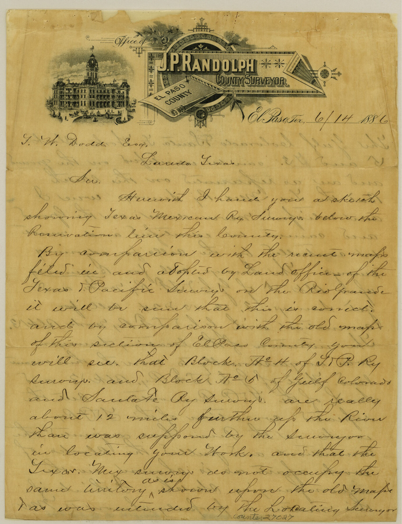
[Correspondence regarding T. M. RR. Co. Block lying west of G. C. & S. F. RR. Block 3, south of the T. & P. RR. Reservation and east of G. S. & S. F. RR. Block 5]
-
Map/Doc
27027
-
Collection
General Map Collection
-
Object Dates
6/14/1886 (Creation Date)
1/26/1983 (File Date)
6/14/1886 (Correspondence Date)
-
People and Organizations
Jno. P. Randolph (Surveyor/Engineer)
-
Counties
Hudspeth El Paso
-
Subjects
Surveying Sketch File
-
Height x Width
11.0 x 8.5 inches
27.9 x 21.6 cm
-
Medium
paper, manuscript
Part of: General Map Collection
Brewster County Rolled Sketch 24B

Print $20.00
- Digital $50.00
Brewster County Rolled Sketch 24B
Size 17.2 x 22.4 inches
Map/Doc 5209
Comanche County Sketch File 20a

Print $2.00
- Digital $50.00
Comanche County Sketch File 20a
Size 12.9 x 8.2 inches
Map/Doc 19105
Chambers County Rolled Sketch 8

Print $20.00
- Digital $50.00
Chambers County Rolled Sketch 8
Size 39.8 x 30.5 inches
Map/Doc 8612
Wheeler County Boundary File 1

Print $24.00
- Digital $50.00
Wheeler County Boundary File 1
Size 14.4 x 8.7 inches
Map/Doc 59856
[Palmer and Castro Counties]
![1763, [Palmer and Castro Counties], General Map Collection](https://historictexasmaps.com/wmedia_w700/maps/1763-1.tif.jpg)
Print $20.00
- Digital $50.00
[Palmer and Castro Counties]
1910
Size 19.3 x 26.3 inches
Map/Doc 1763
Crockett County Sketch File 38

Print $20.00
- Digital $50.00
Crockett County Sketch File 38
1887
Size 20.8 x 30.3 inches
Map/Doc 11220
Sutton County Working Sketch 14

Print $40.00
- Digital $50.00
Sutton County Working Sketch 14
1972
Size 59.5 x 36.8 inches
Map/Doc 62357
Edwards County Working Sketch 59

Print $20.00
- Digital $50.00
Edwards County Working Sketch 59
1954
Size 22.7 x 22.4 inches
Map/Doc 68935

Wood County Sketch File 14

Print $46.00
- Digital $50.00
Wood County Sketch File 14
1907
Size 14.3 x 8.7 inches
Map/Doc 40671
Nautical Chart 885-SC Intracoastal Waterway - Ellender to Galveston Bay, Louisiana-Texas

Print $20.00
- Digital $50.00
Nautical Chart 885-SC Intracoastal Waterway - Ellender to Galveston Bay, Louisiana-Texas
1972
Size 15.9 x 26.8 inches
Map/Doc 75910
[Map of Zapata County]
![4178, [Map of Zapata County], General Map Collection](https://historictexasmaps.com/wmedia_w700/maps/4178.tif.jpg)
Print $20.00
- Digital $50.00
[Map of Zapata County]
1883
Size 20.5 x 20.9 inches
Map/Doc 4178
You may also like
Kendall County Boundary File 2b

Print $4.00
- Digital $50.00
Kendall County Boundary File 2b
Size 10.0 x 8.0 inches
Map/Doc 55754
Flight Mission No. DCL-5C, Frame 48, Kenedy County

Print $20.00
- Digital $50.00
Flight Mission No. DCL-5C, Frame 48, Kenedy County
1943
Size 18.6 x 22.2 inches
Map/Doc 85844
Pecos County Working Sketch 43

Print $40.00
- Digital $50.00
Pecos County Working Sketch 43
1943
Size 19.5 x 50.7 inches
Map/Doc 71515
Tyler County Sketch File 17a

Print $4.00
- Digital $50.00
Tyler County Sketch File 17a
1853
Size 6.6 x 8.0 inches
Map/Doc 38664
Flight Mission No. DCL-7C, Frame 46, Kenedy County

Print $20.00
- Digital $50.00
Flight Mission No. DCL-7C, Frame 46, Kenedy County
1943
Size 15.4 x 15.3 inches
Map/Doc 86034
Liberty County Sketch File 61

Print $12.00
- Digital $50.00
Liberty County Sketch File 61
1950
Size 14.2 x 8.8 inches
Map/Doc 30077
Flight Mission No. DCL-6C, Frame 134, Kenedy County

Print $20.00
- Digital $50.00
Flight Mission No. DCL-6C, Frame 134, Kenedy County
1943
Size 18.5 x 22.2 inches
Map/Doc 85964
Bandera County Working Sketch 53

Print $20.00
- Digital $50.00
Bandera County Working Sketch 53
1985
Size 34.0 x 36.0 inches
Map/Doc 67649
Kent County Boundary File 1

Print $54.00
- Digital $50.00
Kent County Boundary File 1
Size 14.2 x 8.5 inches
Map/Doc 55795
Copy of Surveyor's Field Book, Morris Browning - In Blocks 7, 5 & 4, I&GNRRCo., Hutchinson and Carson Counties, Texas

Print $2.00
- Digital $50.00
Copy of Surveyor's Field Book, Morris Browning - In Blocks 7, 5 & 4, I&GNRRCo., Hutchinson and Carson Counties, Texas
1888
Size 8.9 x 7.1 inches
Map/Doc 62287
Map of Texas. The Proposed Reoccupation of the Rio Grande -- Its Importance to the Union

Print $20.00
Map of Texas. The Proposed Reoccupation of the Rio Grande -- Its Importance to the Union
1965
Size 14.1 x 8.6 inches
Map/Doc 76264
Hudspeth County Sketch File 21a

Print $10.00
- Digital $50.00
Hudspeth County Sketch File 21a
Size 10.6 x 8.4 inches
Map/Doc 26969