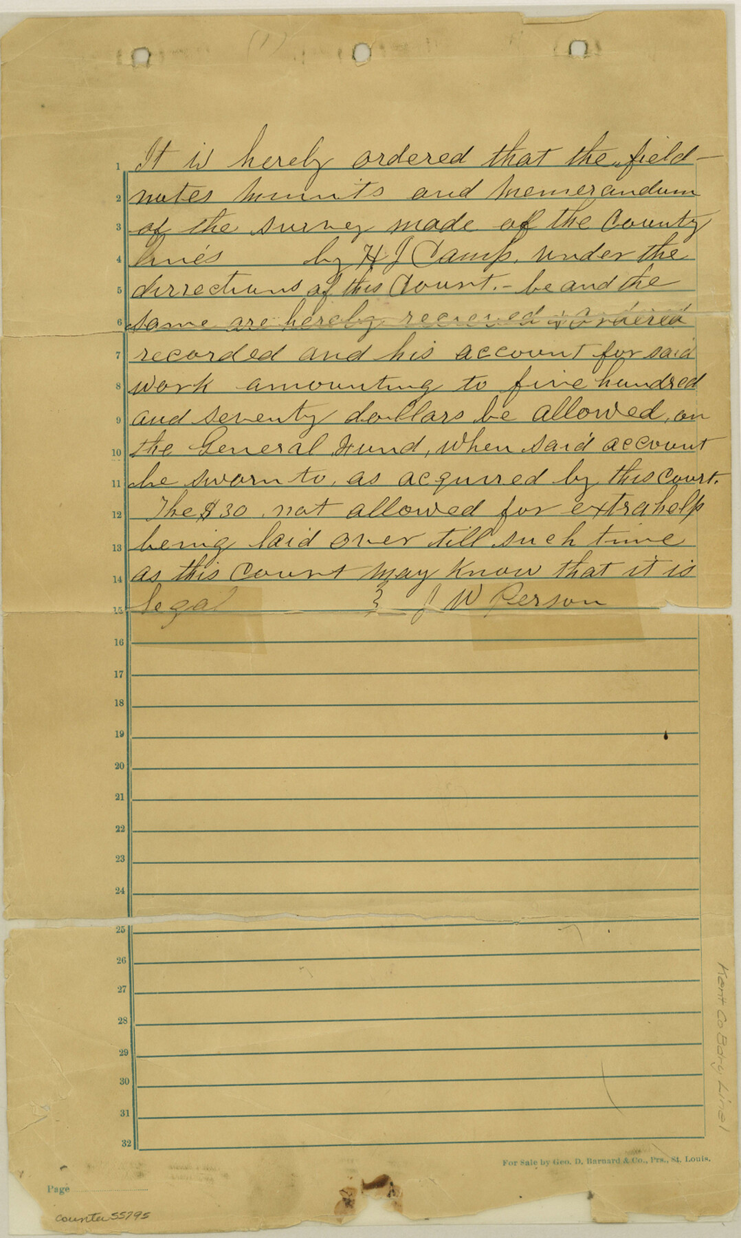
Kent County Boundary File 1
[Fieldnotes of the County lines of Kent County]
-
Map/Doc
55795
-
Collection
General Map Collection
-
Counties
Kent
-
Subjects
County Boundaries
-
Height x Width
14.2 x 8.5 inches
36.1 x 21.6 cm
Part of: General Map Collection

Kent County Boundary File 4a

Print $18.00
- Digital $50.00
Kent County Boundary File 4a
Size 14.2 x 8.5 inches
Map/Doc 55838
Duval County Rolled Sketch 37

Print $20.00
- Digital $50.00
Duval County Rolled Sketch 37
Size 27.1 x 17.9 inches
Map/Doc 5752
Coleman County Sketch File 48

Print $29.00
- Digital $50.00
Coleman County Sketch File 48
1898
Size 8.2 x 12.7 inches
Map/Doc 18799
Crockett County Sketch File 23

Print $2.00
- Digital $50.00
Crockett County Sketch File 23
Size 8.6 x 8.5 inches
Map/Doc 19697
Irion County Rolled Sketch 4

Print $20.00
- Digital $50.00
Irion County Rolled Sketch 4
Size 25.6 x 36.4 inches
Map/Doc 6319
Flight Mission No. CRE-1R, Frame 195, Jackson County

Print $20.00
- Digital $50.00
Flight Mission No. CRE-1R, Frame 195, Jackson County
1956
Size 18.6 x 22.3 inches
Map/Doc 85349
Travis County State Real Property Sketch 8

Print $20.00
- Digital $50.00
Travis County State Real Property Sketch 8
1996
Size 30.5 x 42.6 inches
Map/Doc 77192
Uvalde County Sketch File 12

Print $18.00
- Digital $50.00
Uvalde County Sketch File 12
1887
Size 9.3 x 17.0 inches
Map/Doc 38977
Willacy County Sketch File 3

Print $2.00
- Digital $50.00
Willacy County Sketch File 3
Size 8.5 x 11.0 inches
Map/Doc 90000
Sutton County Working Sketch 51

Print $20.00
- Digital $50.00
Sutton County Working Sketch 51
1955
Size 12.1 x 27.7 inches
Map/Doc 62394
Flight Mission No. DAG-23K, Frame 59, Matagorda County

Print $20.00
- Digital $50.00
Flight Mission No. DAG-23K, Frame 59, Matagorda County
1953
Size 18.5 x 22.3 inches
Map/Doc 86486
You may also like
Leon County Sketch File 36

Print $6.00
- Digital $50.00
Leon County Sketch File 36
1994
Size 14.2 x 8.7 inches
Map/Doc 29850
Hudspeth County Working Sketch 47

Print $20.00
- Digital $50.00
Hudspeth County Working Sketch 47
1984
Size 27.3 x 38.6 inches
Map/Doc 78211
Aransas County Boundary File 7

Print $2.00
- Digital $50.00
Aransas County Boundary File 7
Size 8.8 x 14.2 inches
Map/Doc 50042
City of Andrews

Print $20.00
- Digital $50.00
City of Andrews
1951
Size 25.1 x 24.2 inches
Map/Doc 92454

Cameron County Sketch File 10

Print $8.00
- Digital $50.00
Cameron County Sketch File 10
1989
Size 11.1 x 8.6 inches
Map/Doc 17205

Crosby County Working Sketch 15

Print $20.00
- Digital $50.00
Crosby County Working Sketch 15
1977
Size 34.0 x 35.9 inches
Map/Doc 68449
Jack County Sketch File 4

Print $4.00
- Digital $50.00
Jack County Sketch File 4
1857
Size 9.0 x 12.7 inches
Map/Doc 27506
Outer Continental Shelf Leasing Maps (Louisiana Offshore Operations)

Print $20.00
- Digital $50.00
Outer Continental Shelf Leasing Maps (Louisiana Offshore Operations)
1955
Size 9.7 x 11.3 inches
Map/Doc 76089
Orange County Boundary File 7

Print $10.00
- Digital $50.00
Orange County Boundary File 7
Size 4.1 x 7.6 inches
Map/Doc 57775
Mapa Original de Texas por El Ciudadano Estevan F. Austin Presentado al Exmo. Sr. Presidente por su autor 1829

Print $20.00
- Digital $50.00
Mapa Original de Texas por El Ciudadano Estevan F. Austin Presentado al Exmo. Sr. Presidente por su autor 1829
1830
Size 32.3 x 25.3 inches
Map/Doc 2106