Orange County Boundary File 7
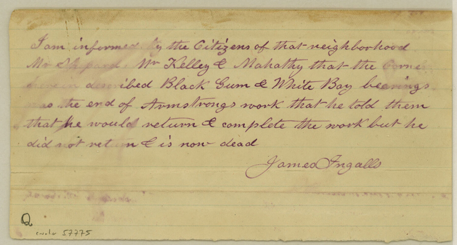
[Description of the line between (Orange and) Jasper and Newton Counties]
-
Map/Doc
57775
-
Collection
General Map Collection
-
Counties
Orange
-
Subjects
County Boundaries
-
Height x Width
4.1 x 7.6 inches
10.4 x 19.3 cm
Part of: General Map Collection
Rio Grande Rectification Project, El Paso and Juarez Valley

Print $20.00
- Digital $50.00
Rio Grande Rectification Project, El Paso and Juarez Valley
1935
Size 11.0 x 29.7 inches
Map/Doc 60864
Presidio County Rolled Sketch 114

Print $20.00
- Digital $50.00
Presidio County Rolled Sketch 114
Size 28.2 x 40.3 inches
Map/Doc 7390
Johnson County Sketch File 26

Print $28.00
- Digital $50.00
Johnson County Sketch File 26
1892
Size 14.3 x 8.8 inches
Map/Doc 28474
Delta County Working Sketch 2

Print $20.00
- Digital $50.00
Delta County Working Sketch 2
1963
Size 26.6 x 25.2 inches
Map/Doc 68639
Tyler County Sketch File 19a

Print $4.00
- Digital $50.00
Tyler County Sketch File 19a
Size 8.1 x 14.1 inches
Map/Doc 38672
Flight Mission No. CGI-3N, Frame 170, Cameron County

Print $20.00
- Digital $50.00
Flight Mission No. CGI-3N, Frame 170, Cameron County
1954
Size 18.6 x 22.3 inches
Map/Doc 84634
Flight Mission No. BRA-9M, Frame 78, Jefferson County

Print $20.00
- Digital $50.00
Flight Mission No. BRA-9M, Frame 78, Jefferson County
1953
Size 18.5 x 22.5 inches
Map/Doc 85661
Concho County Working Sketch 1

Print $20.00
- Digital $50.00
Concho County Working Sketch 1
Size 29.3 x 36.8 inches
Map/Doc 68183
Angelina County Sketch File 15d

Print $20.00
- Digital $50.00
Angelina County Sketch File 15d
1863
Size 8.0 x 6.6 inches
Map/Doc 12980
Coryell County Sketch File 1

Print $13.00
- Digital $50.00
Coryell County Sketch File 1
1852
Size 15.9 x 11.0 inches
Map/Doc 19334
Hardin County Rolled Sketch 22

Print $20.00
- Digital $50.00
Hardin County Rolled Sketch 22
1977
Size 32.0 x 44.4 inches
Map/Doc 9110
Throckmorton County Working Sketch 10

Print $20.00
- Digital $50.00
Throckmorton County Working Sketch 10
1986
Size 22.8 x 36.8 inches
Map/Doc 62119
You may also like
Wheeler County Working Sketch 18

Print $20.00
- Digital $50.00
Wheeler County Working Sketch 18
1985
Size 38.0 x 41.8 inches
Map/Doc 72507
Upton County Sketch File 26

Print $20.00
- Digital $50.00
Upton County Sketch File 26
1928
Size 22.6 x 14.2 inches
Map/Doc 12520
No. 2 Chart of Corpus Christi Pass, Texas

Print $20.00
- Digital $50.00
No. 2 Chart of Corpus Christi Pass, Texas
1878
Size 18.3 x 27.3 inches
Map/Doc 73024
Blanco County Working Sketch 3

Print $20.00
- Digital $50.00
Blanco County Working Sketch 3
Size 14.4 x 16.1 inches
Map/Doc 78189
The Pringle and Grieve Colony. November 1, 1843

Print $20.00
The Pringle and Grieve Colony. November 1, 1843
2020
Size 23.0 x 17.7 inches
Map/Doc 96371
Galveston County NRC Article 33.136 Location Key Sheet

Print $20.00
- Digital $50.00
Galveston County NRC Article 33.136 Location Key Sheet
1993
Size 27.3 x 23.0 inches
Map/Doc 83000
Presidio County Rolled Sketch 115

Print $20.00
- Digital $50.00
Presidio County Rolled Sketch 115
1980
Size 19.3 x 22.2 inches
Map/Doc 7391
Garza County Rolled Sketch 11 & 11A

Print $31.00
- Digital $50.00
Garza County Rolled Sketch 11 & 11A
1915
Size 10.3 x 15.5 inches
Map/Doc 45214
Madison County Working Sketch Graphic Index

Print $20.00
- Digital $50.00
Madison County Working Sketch Graphic Index
1922
Size 29.4 x 47.6 inches
Map/Doc 76628
Texas, Copano Bay, Mission Bay and Fish Point

Print $40.00
- Digital $50.00
Texas, Copano Bay, Mission Bay and Fish Point
1934
Size 33.3 x 48.9 inches
Map/Doc 73433
Plat of South Side Addition on Section 37 Block 17, Wheeler County, Texas

Print $20.00
- Digital $50.00
Plat of South Side Addition on Section 37 Block 17, Wheeler County, Texas
Size 12.0 x 16.9 inches
Map/Doc 92103
Zavalla County School Land Hockley County, Texas

Print $20.00
- Digital $50.00
Zavalla County School Land Hockley County, Texas
1956
Size 41.6 x 20.2 inches
Map/Doc 92254