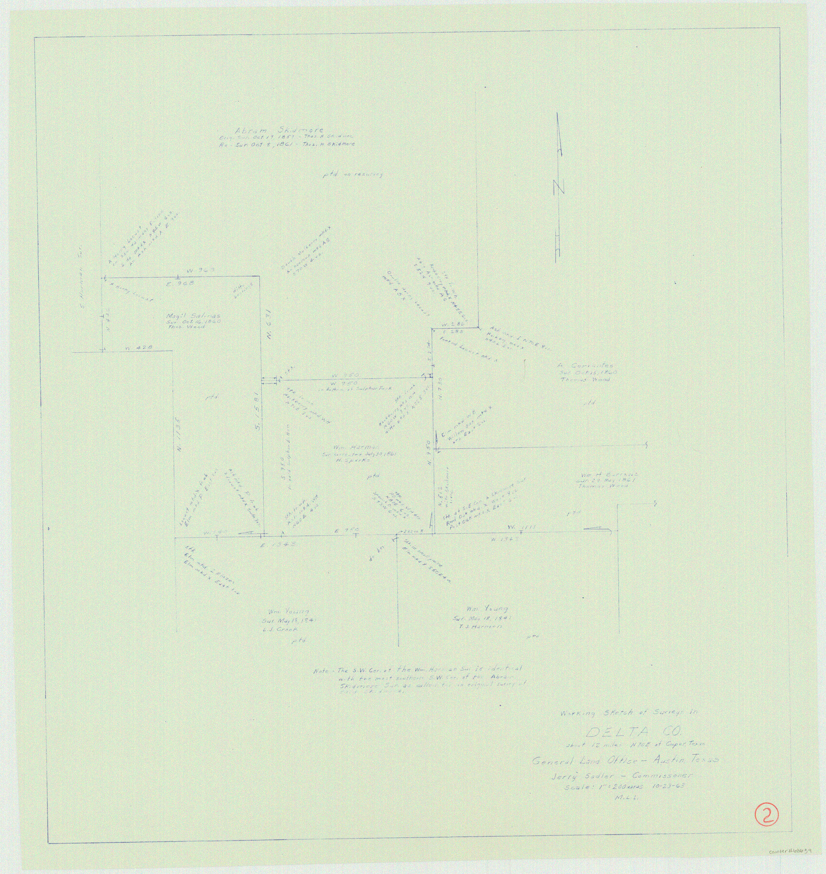
Delta County Working Sketch 2
-
Map/Doc
68639
-
Collection
General Map Collection
-
Object Dates
10/23/1963 (Creation Date)
-
People and Organizations
M. L. Liles (Draftsman)
-
Counties
Delta
-
Subjects
Surveying Working Sketch
-
Height x Width
26.6 x 25.2 inches
67.6 x 64.0 cm
-
Scale
1" = 200 varas
Part of: General Map Collection
Guadalupe County Working Sketch 8

Print $20.00
- Digital $50.00
Guadalupe County Working Sketch 8
1955
Size 23.6 x 38.6 inches
Map/Doc 63317
Map of Parker County

Print $20.00
- Digital $50.00
Map of Parker County
1871
Size 20.9 x 18.4 inches
Map/Doc 3942
Township No. 5 South Range No. 15 West, Indian Meridian, Oklahoma

Print $4.00
- Digital $50.00
Township No. 5 South Range No. 15 West, Indian Meridian, Oklahoma
1927
Size 18.2 x 23.9 inches
Map/Doc 75136
Stephens County Working Sketch 24

Print $20.00
- Digital $50.00
Stephens County Working Sketch 24
1976
Size 39.2 x 31.9 inches
Map/Doc 63967
Baylor County Working Sketch 14

Print $40.00
- Digital $50.00
Baylor County Working Sketch 14
1982
Size 33.5 x 55.1 inches
Map/Doc 67299
Gaines County Rolled Sketch 27

Print $20.00
- Digital $50.00
Gaines County Rolled Sketch 27
1983
Size 35.6 x 41.8 inches
Map/Doc 9042
Limestone County Sketch File 2

Print $2.00
- Digital $50.00
Limestone County Sketch File 2
Size 8.0 x 6.2 inches
Map/Doc 30157
Kenedy County Aerial Photograph Index Sheet 5

Print $20.00
- Digital $50.00
Kenedy County Aerial Photograph Index Sheet 5
1943
Size 23.5 x 19.6 inches
Map/Doc 89046
Flight Mission No. BQY-4M, Frame 44, Harris County

Print $20.00
- Digital $50.00
Flight Mission No. BQY-4M, Frame 44, Harris County
1953
Size 18.5 x 22.4 inches
Map/Doc 85259
Hunt County Rolled Sketch 2

Print $20.00
- Digital $50.00
Hunt County Rolled Sketch 2
Size 31.8 x 29.9 inches
Map/Doc 9240
Edwards County Working Sketch 28

Print $20.00
- Digital $50.00
Edwards County Working Sketch 28
1946
Size 30.0 x 33.5 inches
Map/Doc 68904
Jefferson Co.

Print $20.00
- Digital $50.00
Jefferson Co.
1918
Size 47.1 x 41.0 inches
Map/Doc 66884
You may also like
Map of Silverton, County Seat of Briscoe County, Texas

Print $20.00
- Digital $50.00
Map of Silverton, County Seat of Briscoe County, Texas
1891
Size 24.3 x 19.8 inches
Map/Doc 4832
Williamson County Rolled Sketch 6

Print $20.00
- Digital $50.00
Williamson County Rolled Sketch 6
1941
Size 26.0 x 18.9 inches
Map/Doc 8264
Report on the Meridional Boundary between Louisiana and Texas, retracement by the Louisiana Geodetic Survey

Print $2.00
- Digital $50.00
Report on the Meridional Boundary between Louisiana and Texas, retracement by the Louisiana Geodetic Survey
Size 11.2 x 8.8 inches
Map/Doc 61174
Rio Grande - Fernando Sheet

Print $40.00
- Digital $50.00
Rio Grande - Fernando Sheet
1925
Size 28.8 x 66.7 inches
Map/Doc 65115
Culberson County Working Sketch 1

Print $20.00
- Digital $50.00
Culberson County Working Sketch 1
Size 21.6 x 42.7 inches
Map/Doc 68453
Kerr County Working Sketch 35

Print $20.00
- Digital $50.00
Kerr County Working Sketch 35
1981
Size 35.2 x 15.5 inches
Map/Doc 70066
Brazoria County NRC Article 33.136 Sketch 8

Print $20.00
- Digital $50.00
Brazoria County NRC Article 33.136 Sketch 8
2006
Size 17.1 x 11.2 inches
Map/Doc 83649
Flight Mission No. DCL-7C, Frame 134, Kenedy County

Print $20.00
- Digital $50.00
Flight Mission No. DCL-7C, Frame 134, Kenedy County
1943
Size 18.5 x 22.3 inches
Map/Doc 86091
[Sketch showing I. G. Yates SF 12341 and surrounding surveys]
![93106, [Sketch showing I. G. Yates SF 12341 and surrounding surveys], Twichell Survey Records](https://historictexasmaps.com/wmedia_w700/maps/93106-1.tif.jpg)
Print $20.00
- Digital $50.00
[Sketch showing I. G. Yates SF 12341 and surrounding surveys]
Size 25.9 x 21.6 inches
Map/Doc 93106
Hardin County Sketch File 59

Print $6.00
- Digital $50.00
Hardin County Sketch File 59
Size 16.8 x 11.6 inches
Map/Doc 25233
Roberts County Working Sketch 31

Print $20.00
- Digital $50.00
Roberts County Working Sketch 31
1978
Size 26.6 x 22.4 inches
Map/Doc 63557
Schönberg's map of Texas.

Print $20.00
Schönberg's map of Texas.
1866
Size 11.0 x 13.0 inches
Map/Doc 93575