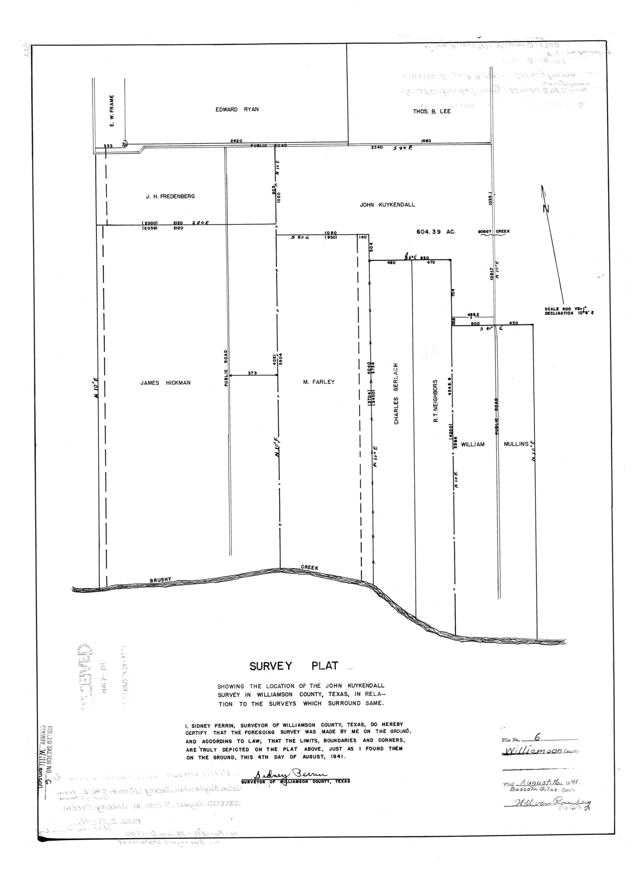
Williamson County Rolled Sketch 6
Survey plat showing the location of the John Kuykendall survey in Williamson County, Texas, in relation to the surveys which surround same
-
Map/Doc
8264
-
Collection
General Map Collection
-
Object Dates
1941/8/4 (Creation Date)
1941/8/16 (File Date)
-
People and Organizations
Sidney Perrin (Surveyor/Engineer)
-
Counties
Williamson
-
Subjects
Surveying Rolled Sketch
-
Height x Width
26.0 x 18.9 inches
66.0 x 48.0 cm
-
Scale
1" = 400 varas
Part of: General Map Collection
Kaufman County Sketch File 16

Print $4.00
- Digital $50.00
Kaufman County Sketch File 16
Size 10.1 x 8.1 inches
Map/Doc 28655
Travis County Sketch File XYZ

Print $4.00
- Digital $50.00
Travis County Sketch File XYZ
Size 10.1 x 8.3 inches
Map/Doc 38352

Webb County Rolled Sketch EF4

Print $20.00
- Digital $50.00
Webb County Rolled Sketch EF4
1929
Size 33.2 x 24.4 inches
Map/Doc 8226
Knox County Sketch File 25

Print $10.00
- Digital $50.00
Knox County Sketch File 25
1872
Size 12.8 x 8.2 inches
Map/Doc 29257
Flight Mission No. BQR-13K, Frame 164, Brazoria County

Print $20.00
- Digital $50.00
Flight Mission No. BQR-13K, Frame 164, Brazoria County
1952
Size 18.8 x 22.4 inches
Map/Doc 84089
El Paso County Working Sketch 5

Print $20.00
- Digital $50.00
El Paso County Working Sketch 5
1916
Size 21.5 x 37.2 inches
Map/Doc 69027
Hall County Sketch File 18

Print $20.00
- Digital $50.00
Hall County Sketch File 18
Size 16.8 x 35.1 inches
Map/Doc 11609
Amistad International Reservoir on Rio Grande 65

Print $20.00
- Digital $50.00
Amistad International Reservoir on Rio Grande 65
1949
Size 28.2 x 39.8 inches
Map/Doc 73350
Real County Sketch File 18

Print $28.00
- Digital $50.00
Real County Sketch File 18
1964
Size 14.3 x 8.9 inches
Map/Doc 35076

Flight Mission No. CLL-1N, Frame 185, Willacy County

Print $20.00
- Digital $50.00
Flight Mission No. CLL-1N, Frame 185, Willacy County
1954
Size 18.4 x 22.1 inches
Map/Doc 87055
You may also like
Menard County Working Sketch 34

Print $20.00
- Digital $50.00
Menard County Working Sketch 34
2003
Size 27.1 x 44.4 inches
Map/Doc 82028
Motley County Boundary File 2e

Print $40.00
- Digital $50.00
Motley County Boundary File 2e
Size 29.4 x 96.1 inches
Map/Doc 57561
Harris County Rolled Sketch 85

Print $20.00
- Digital $50.00
Harris County Rolled Sketch 85
1968
Size 22.0 x 32.0 inches
Map/Doc 6119
Reeves County Working Sketch 37

Print $40.00
- Digital $50.00
Reeves County Working Sketch 37
1971
Size 57.7 x 36.7 inches
Map/Doc 63480
Brazos River, Brazos River Sheet 2

Print $6.00
- Digital $50.00
Brazos River, Brazos River Sheet 2
1926
Size 25.0 x 31.4 inches
Map/Doc 65294
Coast of Texas from head of East Bay Galveston Harbor to Sabine Pass

Print $40.00
- Digital $50.00
Coast of Texas from head of East Bay Galveston Harbor to Sabine Pass
1882
Size 32.3 x 53.9 inches
Map/Doc 69840
Hunt County Sketch File 30

Print $6.00
- Digital $50.00
Hunt County Sketch File 30
1862
Size 8.1 x 7.5 inches
Map/Doc 27132
Bexar County Sketch File 27

Print $4.00
- Digital $50.00
Bexar County Sketch File 27
1860
Size 8.6 x 6.5 inches
Map/Doc 14490
[Section 34, Block 194 G. C. & S. F.]
![91672, [Section 34, Block 194 G. C. & S. F.], Twichell Survey Records](https://historictexasmaps.com/wmedia_w700/maps/91672-1.tif.jpg)
Print $2.00
- Digital $50.00
[Section 34, Block 194 G. C. & S. F.]
1927
Size 7.5 x 5.9 inches
Map/Doc 91672
[Aransas and Corpus Christi Bays]
![140, [Aransas and Corpus Christi Bays], General Map Collection](https://historictexasmaps.com/wmedia_w700/maps/140.tif.jpg)
Print $3.00
- Digital $50.00
[Aransas and Corpus Christi Bays]
1839
Size 11.4 x 16.5 inches
Map/Doc 140
Treaty to Resolve Pending Boundary Differences and Maintain the Rio Grande and Colorado River as the International Boundary Between the United States of American and Mexico

Print $4.00
- Digital $50.00
Treaty to Resolve Pending Boundary Differences and Maintain the Rio Grande and Colorado River as the International Boundary Between the United States of American and Mexico
1970
Size 10.9 x 18.1 inches
Map/Doc 83101
Flight Mission No. DCL-5C, Frame 69, Kenedy County

Print $20.00
- Digital $50.00
Flight Mission No. DCL-5C, Frame 69, Kenedy County
1943
Size 18.5 x 22.3 inches
Map/Doc 85852