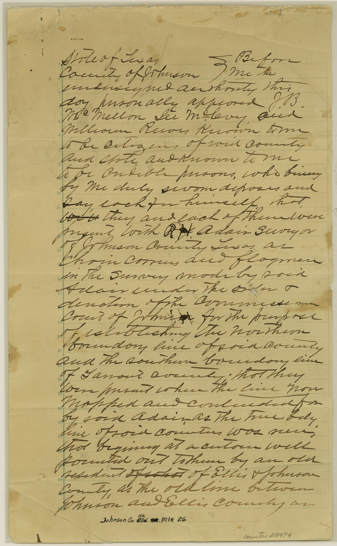
Johnson County Sketch File 26
[Report regarding true northern boundary of Johnson County]
-
Map/Doc
28474
-
Collection
General Map Collection
-
Object Dates
2/1/1892 (Creation Date)
11/18/1891 (Survey Date)
-
People and Organizations
R.H. Adair (Surveyor/Engineer)
Lee McCoy (Chainman)
William Reeves (Chainman)
Goodfellow (Surveyor/Engineer)
John R. Ransone (Surveyor/Engineer)
Finly (Surveyor/Engineer)
-
Counties
Johnson Ellis Tarrant Fannin Denton
-
Subjects
Surveying Sketch File
-
Height x Width
14.3 x 8.8 inches
36.3 x 22.4 cm
-
Medium
multi-page, multi-format
-
Comments
See Johnson County Rolled Sketch B (6449) for sketch.
-
Features
Mountain Creek
Cedar Hill Road
Mansfield Road
Birdsville Crossing
Related maps
Johnson County Rolled Sketch B

Print $20.00
- Digital $50.00
Johnson County Rolled Sketch B
1891
Size 28.2 x 38.9 inches
Map/Doc 6449
Part of: General Map Collection
El Paso County Working Sketch 17

Print $20.00
- Digital $50.00
El Paso County Working Sketch 17
1958
Size 28.4 x 26.3 inches
Map/Doc 69039
Fannin County Rolled Sketch 18B

Print $20.00
- Digital $50.00
Fannin County Rolled Sketch 18B
Size 12.7 x 16.1 inches
Map/Doc 5869
Houston Ship Channel, Alexander Island to Carpenter Bayou

Print $20.00
- Digital $50.00
Houston Ship Channel, Alexander Island to Carpenter Bayou
1971
Size 35.1 x 46.7 inches
Map/Doc 69907
Borden County

Print $20.00
- Digital $50.00
Borden County
1922
Size 44.7 x 38.7 inches
Map/Doc 66718
Angelina County Sketch File 13

Print $4.00
- Digital $50.00
Angelina County Sketch File 13
1860
Size 13.0 x 8.2 inches
Map/Doc 12957
America's Fun-Tier: Texas 1967 Official State Highway Map

Digital $50.00
America's Fun-Tier: Texas 1967 Official State Highway Map
Size 28.3 x 36.6 inches
Map/Doc 94322
[San Antonio & Aransas Pass Railway Co.]
![64261, [San Antonio & Aransas Pass Railway Co.], General Map Collection](https://historictexasmaps.com/wmedia_w700/maps/64261.tif.jpg)
Print $20.00
- Digital $50.00
[San Antonio & Aransas Pass Railway Co.]
Size 22.9 x 35.1 inches
Map/Doc 64261
Central Part of Jeff Davis Co.

Print $40.00
- Digital $50.00
Central Part of Jeff Davis Co.
1982
Size 54.2 x 41.6 inches
Map/Doc 77326
Map of the lower surveys in Robertsons Colony Sold by the State of Coahuila and Texas

Print $20.00
- Digital $50.00
Map of the lower surveys in Robertsons Colony Sold by the State of Coahuila and Texas
1834
Size 22.0 x 28.5 inches
Map/Doc 122
Flight Mission No. DQN-1K, Frame 51, Calhoun County

Print $20.00
- Digital $50.00
Flight Mission No. DQN-1K, Frame 51, Calhoun County
1953
Size 18.6 x 22.3 inches
Map/Doc 84151
Moore County Sketch File 13

Print $24.00
- Digital $50.00
Moore County Sketch File 13
1919
Size 7.0 x 8.7 inches
Map/Doc 31949
[Geological Map of Texas]
![62962, [Geological Map of Texas], General Map Collection](https://historictexasmaps.com/wmedia_w700/maps/62962.tif.jpg)
Print $20.00
- Digital $50.00
[Geological Map of Texas]
Size 17.6 x 18.1 inches
Map/Doc 62962
You may also like
Liberty County Sketch File 27

Print $5.00
- Digital $50.00
Liberty County Sketch File 27
Size 11.5 x 9.3 inches
Map/Doc 29948
Garza County Working Sketch 13

Print $20.00
- Digital $50.00
Garza County Working Sketch 13
1956
Size 19.0 x 12.7 inches
Map/Doc 63160
Edwards County Working Sketch 122

Print $20.00
- Digital $50.00
Edwards County Working Sketch 122
1976
Size 25.8 x 33.9 inches
Map/Doc 68998
Nueces County Sketch File 26 1/2

Print $20.00
- Digital $50.00
Nueces County Sketch File 26 1/2
1902
Size 18.4 x 23.0 inches
Map/Doc 42186
Jefferson County Working Sketch 42

Print $20.00
- Digital $50.00
Jefferson County Working Sketch 42
1996
Size 31.7 x 47.2 inches
Map/Doc 66586
King County Sketch File 6 (1)

Print $43.00
- Digital $50.00
King County Sketch File 6 (1)
1897
Size 14.5 x 15.7 inches
Map/Doc 29027
A. H. Baer Estate

Print $20.00
- Digital $50.00
A. H. Baer Estate
Size 18.4 x 15.6 inches
Map/Doc 92748
Flight Mission No. CLL-3N, Frame 37, Willacy County

Print $20.00
- Digital $50.00
Flight Mission No. CLL-3N, Frame 37, Willacy County
1954
Size 18.6 x 22.2 inches
Map/Doc 87095
Trinity River, Sycamore Crossing Sheet/Denton Creek

Print $6.00
- Digital $50.00
Trinity River, Sycamore Crossing Sheet/Denton Creek
1928
Size 26.7 x 34.7 inches
Map/Doc 65224
Sheet 2 copied from Peck Book 6 [Strip Map showing T. & P. connecting lines]
![93172, Sheet 2 copied from Peck Book 6 [Strip Map showing T. & P. connecting lines], Twichell Survey Records](https://historictexasmaps.com/wmedia_w700/maps/93172-1.tif.jpg)
Print $40.00
- Digital $50.00
Sheet 2 copied from Peck Book 6 [Strip Map showing T. & P. connecting lines]
1909
Size 6.5 x 53.9 inches
Map/Doc 93172
Flight Mission No. DQN-2K, Frame 119, Calhoun County

Print $20.00
- Digital $50.00
Flight Mission No. DQN-2K, Frame 119, Calhoun County
1953
Size 16.8 x 16.5 inches
Map/Doc 84295
Duval County Working Sketch 58

Print $20.00
- Digital $50.00
Duval County Working Sketch 58
Size 21.0 x 33.0 inches
Map/Doc 67498