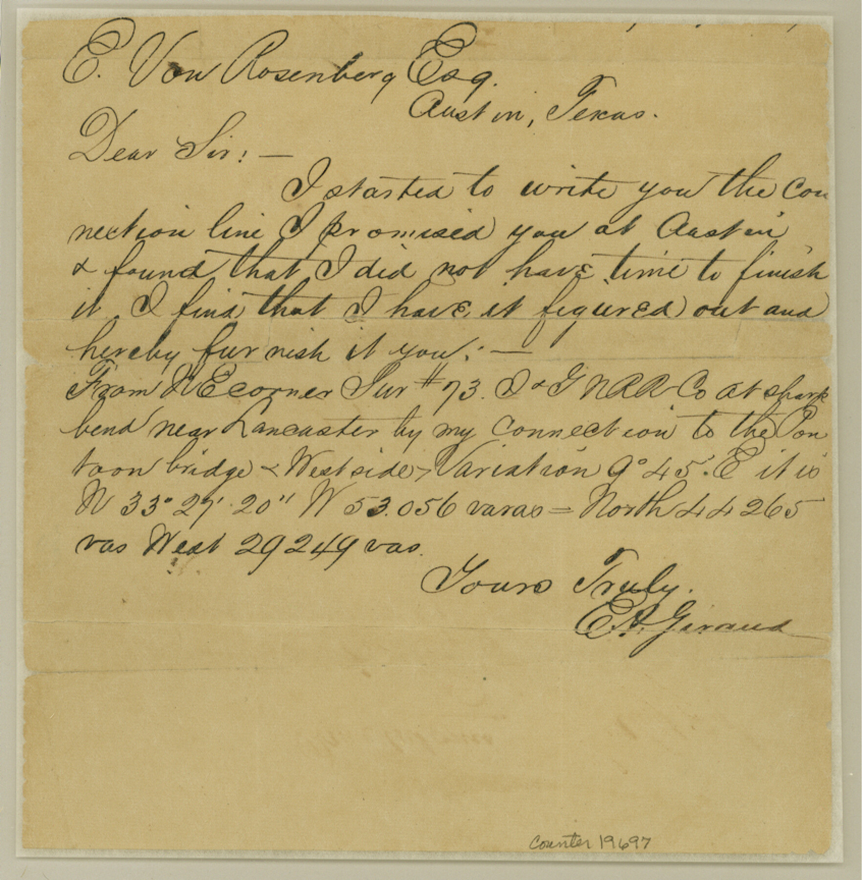
Crockett County Sketch File 23
[Connecting line from northeast corner of 73, I. & G. N. RR. Co. to Pontoon Bridge]
-
Map/Doc
19697
-
Collection
General Map Collection
-
People and Organizations
E.A. Giraud (Surveyor/Engineer)
-
Counties
Crockett
-
Subjects
Surveying Sketch File
-
Height x Width
8.6 x 8.5 inches
21.8 x 21.6 cm
-
Medium
paper, manuscript
Part of: General Map Collection
Flight Mission No. BRA-7M, Frame 83, Jefferson County

Print $20.00
- Digital $50.00
Flight Mission No. BRA-7M, Frame 83, Jefferson County
1953
Size 16.1 x 16.1 inches
Map/Doc 85505
Bailey County Working Sketch 4

Print $20.00
- Digital $50.00
Bailey County Working Sketch 4
1937
Size 27.0 x 32.0 inches
Map/Doc 67591
Gregg County Sketch File 1F

Print $4.00
- Digital $50.00
Gregg County Sketch File 1F
1850
Size 12.2 x 7.8 inches
Map/Doc 24547
Pecos County Rolled Sketch 163

Print $20.00
- Digital $50.00
Pecos County Rolled Sketch 163
Size 28.2 x 23.9 inches
Map/Doc 7286
Sabine County Working Sketch 4

Print $20.00
- Digital $50.00
Sabine County Working Sketch 4
1913
Size 23.7 x 32.0 inches
Map/Doc 63675
Terry County Sketch File 5

Print $40.00
- Digital $50.00
Terry County Sketch File 5
1916
Size 15.6 x 58.6 inches
Map/Doc 10391
Fannin County Boundary File 3

Print $36.00
- Digital $50.00
Fannin County Boundary File 3
Size 13.2 x 8.8 inches
Map/Doc 53295
Knox County Working Sketch 18

Print $20.00
- Digital $50.00
Knox County Working Sketch 18
1988
Size 40.0 x 29.7 inches
Map/Doc 70260
Anderson County Sketch File 2

Print $4.00
- Digital $50.00
Anderson County Sketch File 2
1847
Size 12.6 x 8.2 inches
Map/Doc 12739
[Texas Gulf Coast from Rio Grande to Sabine Lake]
![72687, [Texas Gulf Coast from Rio Grande to Sabine Lake], General Map Collection](https://historictexasmaps.com/wmedia_w700/maps/72687.tif.jpg)
Print $20.00
- Digital $50.00
[Texas Gulf Coast from Rio Grande to Sabine Lake]
Size 28.1 x 18.3 inches
Map/Doc 72687
Tarrant County Working Sketch 1

Print $20.00
- Digital $50.00
Tarrant County Working Sketch 1
1939
Size 12.2 x 18.9 inches
Map/Doc 62418
Willacy County Aerial Photograph Index Sheet 1

Print $20.00
- Digital $50.00
Willacy County Aerial Photograph Index Sheet 1
1940
Size 24.0 x 19.7 inches
Map/Doc 83755
You may also like
Flight Mission No. DAG-17K, Frame 125, Matagorda County

Print $20.00
- Digital $50.00
Flight Mission No. DAG-17K, Frame 125, Matagorda County
1952
Size 18.6 x 22.4 inches
Map/Doc 86345
Map showing lands acquired for reservoir purposes in connection with Lake Worth and the boundary of territory annexed to the City of Fort Worth, Texas

Print $40.00
- Digital $50.00
Map showing lands acquired for reservoir purposes in connection with Lake Worth and the boundary of territory annexed to the City of Fort Worth, Texas
Size 46.6 x 59.6 inches
Map/Doc 62210
Official Map City of Lubbock Lubbock County, Texas

Print $20.00
- Digital $50.00
Official Map City of Lubbock Lubbock County, Texas
1927
Size 44.6 x 33.4 inches
Map/Doc 93220
Flight Mission No. BRA-7M, Frame 134, Jefferson County

Print $20.00
- Digital $50.00
Flight Mission No. BRA-7M, Frame 134, Jefferson County
1953
Size 18.6 x 22.5 inches
Map/Doc 85528
Wichita County

Print $20.00
- Digital $50.00
Wichita County
1971
Size 35.8 x 37.7 inches
Map/Doc 77457
South Part Brewster Co.

Print $40.00
- Digital $50.00
South Part Brewster Co.
1915
Size 50.0 x 35.2 inches
Map/Doc 89723
Gulf, Texas & Western Railway

Print $40.00
- Digital $50.00
Gulf, Texas & Western Railway
1909
Size 18.7 x 103.5 inches
Map/Doc 64431
Eastland County Sketch File 6

Print $4.00
- Digital $50.00
Eastland County Sketch File 6
1871
Size 8.3 x 12.8 inches
Map/Doc 21572
Sketch Showing all that Portion of Block 24 North of Santa Fe R. R. Right-of-Way in Original Town of Lubbock

Print $20.00
- Digital $50.00
Sketch Showing all that Portion of Block 24 North of Santa Fe R. R. Right-of-Way in Original Town of Lubbock
1925
Size 26.9 x 34.4 inches
Map/Doc 92809
Clay County Sketch File 19

Print $5.00
- Digital $50.00
Clay County Sketch File 19
Size 9.2 x 9.9 inches
Map/Doc 18429
[H. & G. N. Block B3]
![90273, [H. & G. N. Block B3], Twichell Survey Records](https://historictexasmaps.com/wmedia_w700/maps/90273-1.tif.jpg)
Print $20.00
- Digital $50.00
[H. & G. N. Block B3]
1887
Size 20.3 x 18.8 inches
Map/Doc 90273
Atascosa County Sketch File 15

Print $6.00
- Digital $50.00
Atascosa County Sketch File 15
1879
Size 7.1 x 13.5 inches
Map/Doc 13775