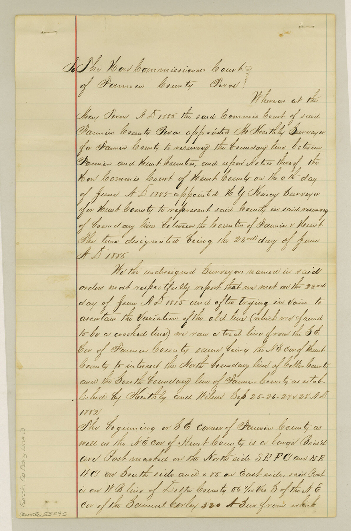
Fannin County Boundary File 3
Map of Fannin and Hunt County Line
-
Map/Doc
53295
-
Collection
General Map Collection
-
Counties
Fannin
-
Subjects
County Boundaries
-
Height x Width
13.2 x 8.8 inches
33.5 x 22.4 cm
Part of: General Map Collection
Le Nouveau Mexique avec la partie Septentrionale de l'Ancien ou de la Nouvelle Espagne

Print $20.00
- Digital $50.00
Le Nouveau Mexique avec la partie Septentrionale de l'Ancien ou de la Nouvelle Espagne
1780
Size 10.0 x 14.4 inches
Map/Doc 97277
Office sketch of surveys on St. Joseph Island and Mustang Island in Aransas & Nueces Cos.

Print $20.00
- Digital $50.00
Office sketch of surveys on St. Joseph Island and Mustang Island in Aransas & Nueces Cos.
1978
Size 42.8 x 17.7 inches
Map/Doc 2252
Map of [Coleman County]
![3413, Map of [Coleman County], General Map Collection](https://historictexasmaps.com/wmedia_w700/maps/3413-1.tif.jpg)
Print $20.00
- Digital $50.00
Map of [Coleman County]
1878
Size 24.9 x 21.9 inches
Map/Doc 3413
Brazoria County NRC Article 33.136 Sketch 30

Print $24.00
Brazoria County NRC Article 33.136 Sketch 30
2025
Map/Doc 97475
Carson County Sketch File 6a

Print $10.00
- Digital $50.00
Carson County Sketch File 6a
1928
Size 14.1 x 8.4 inches
Map/Doc 17374
Flight Mission No. DIX-6P, Frame 120, Aransas County

Print $20.00
- Digital $50.00
Flight Mission No. DIX-6P, Frame 120, Aransas County
1956
Size 18.7 x 22.2 inches
Map/Doc 83826
Hockley County Rolled Sketch 5

Print $40.00
- Digital $50.00
Hockley County Rolled Sketch 5
Size 80.8 x 29.5 inches
Map/Doc 9175
Edwards County Working Sketch 48

Print $20.00
- Digital $50.00
Edwards County Working Sketch 48
1950
Size 46.3 x 38.2 inches
Map/Doc 68924
Flight Mission No. CRK-5P, Frame 158, Refugio County

Print $20.00
- Digital $50.00
Flight Mission No. CRK-5P, Frame 158, Refugio County
1956
Size 18.6 x 22.5 inches
Map/Doc 86939
[Map of Located Land of Gulf, Colorado & Santa Fe Ry. Co. through Denton]
![64340, [Map of Located Land of Gulf, Colorado & Santa Fe Ry. Co. through Denton], General Map Collection](https://historictexasmaps.com/wmedia_w700/maps/64340.tif.jpg)
Print $40.00
- Digital $50.00
[Map of Located Land of Gulf, Colorado & Santa Fe Ry. Co. through Denton]
Size 122.8 x 28.3 inches
Map/Doc 64340
Brewster County Rolled Sketch 22F

Print $20.00
- Digital $50.00
Brewster County Rolled Sketch 22F
1909
Size 19.0 x 25.4 inches
Map/Doc 5206
Hudspeth County Sketch File 16

Print $10.00
- Digital $50.00
Hudspeth County Sketch File 16
1925
Size 14.3 x 8.8 inches
Map/Doc 26948
You may also like
Travis County Sketch File 6

Print $8.00
- Digital $50.00
Travis County Sketch File 6
1841
Size 13.8 x 10.9 inches
Map/Doc 38283
Gulf Intracoastal Waterway, Tex. - Aransas Bay to Corpus Christi Bay - Modified Route of Main Channel/Dredging

Print $20.00
- Digital $50.00
Gulf Intracoastal Waterway, Tex. - Aransas Bay to Corpus Christi Bay - Modified Route of Main Channel/Dredging
1958
Size 31.3 x 42.6 inches
Map/Doc 61894
Crosby County Sketch File 31

Print $20.00
- Digital $50.00
Crosby County Sketch File 31
Size 35.0 x 14.0 inches
Map/Doc 11257
Cherokee County Sketch File 4

Print $7.00
- Digital $50.00
Cherokee County Sketch File 4
1850
Size 10.3 x 8.2 inches
Map/Doc 18117
Tyler County Rolled Sketch 8

Print $20.00
- Digital $50.00
Tyler County Rolled Sketch 8
1965
Size 18.1 x 25.4 inches
Map/Doc 8058
Concho County Sketch File 21

Print $6.00
- Digital $50.00
Concho County Sketch File 21
Size 7.3 x 11.1 inches
Map/Doc 19143

Dallas County Working Sketch 17

Print $40.00
- Digital $50.00
Dallas County Working Sketch 17
Size 23.3 x 50.5 inches
Map/Doc 68583
Bandera County Working Sketch 59

Print $20.00
- Digital $50.00
Bandera County Working Sketch 59
2003
Size 41.1 x 33.9 inches
Map/Doc 78346
Floyd County Rolled Sketch 11

Print $20.00
- Digital $50.00
Floyd County Rolled Sketch 11
2000
Size 15.5 x 20.9 inches
Map/Doc 5884
Pecos County Rolled Sketch 35

Print $20.00
- Digital $50.00
Pecos County Rolled Sketch 35
Size 33.2 x 38.1 inches
Map/Doc 9693
Williamson County

Print $40.00
- Digital $50.00
Williamson County
1888
Size 37.1 x 54.0 inches
Map/Doc 16930