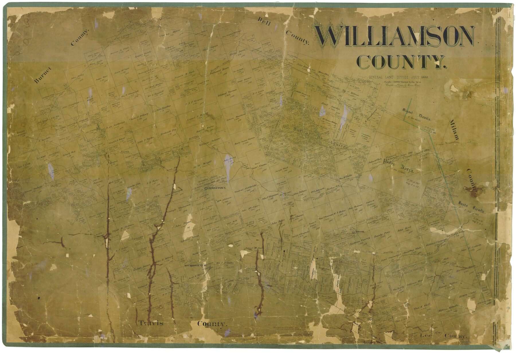
Williamson County
-
Map/Doc
16930
-
Collection
General Map Collection
-
Object Dates
7/1888 (Creation Date)
-
People and Organizations
Herman Pressler (Draftsman)
-
Counties
Williamson
-
Subjects
County
-
Height x Width
37.1 x 54.0 inches
94.2 x 137.2 cm
-
Medium
paper, manuscript
-
Comments
Help Save Texas History - Adopt Me!
-
Features
South Fork of San Gabriel River
Mustang Creek
Cummings
Dry Fork [of Brushy Creek]
Battleground Creek
Lake Creek
Brueggerhoff
Round Rock
Taylor
Brushy Creek
Leander
Thorndale
Turkey Creek
San Gabriel River
Salado River
Georgetown
Circleville
Liberty Hill
North Fork of San Gabriel River
Oppossum Creek
Williamson Creek
Berry's Fork of San Gabriel River
Yankee Creek
Granger
Bear Creek
Bartlett
Donaho Creek
Indian Creek
Part of: General Map Collection
Duval County Working Sketch 43

Print $20.00
- Digital $50.00
Duval County Working Sketch 43
1977
Size 30.8 x 30.5 inches
Map/Doc 68767
Flight Mission No. BRE-1P, Frame 53, Nueces County

Print $20.00
- Digital $50.00
Flight Mission No. BRE-1P, Frame 53, Nueces County
1956
Size 18.5 x 22.4 inches
Map/Doc 86642
[Sketch for Mineral Application 13440]
![65673, [Sketch for Mineral Application 13440], General Map Collection](https://historictexasmaps.com/wmedia_w700/maps/65673-1.tif.jpg)
Print $40.00
- Digital $50.00
[Sketch for Mineral Application 13440]
Size 42.4 x 66.0 inches
Map/Doc 65673
Hardeman County Boundary File 38

Print $70.00
- Digital $50.00
Hardeman County Boundary File 38
Size 12.9 x 8.2 inches
Map/Doc 54400
Jefferson County Rolled Sketch 20

Print $60.00
- Digital $50.00
Jefferson County Rolled Sketch 20
1935
Size 29.2 x 36.2 inches
Map/Doc 9285
Map of Clay County

Print $20.00
- Digital $50.00
Map of Clay County
1874
Size 30.3 x 20.1 inches
Map/Doc 3403
Hudspeth County Sketch File 50

Print $20.00
- Digital $50.00
Hudspeth County Sketch File 50
Size 11.2 x 8.7 inches
Map/Doc 42948

[Maps of surveys in Reeves & Culberson Cos]
![61139, [Maps of surveys in Reeves & Culberson Cos], General Map Collection](https://historictexasmaps.com/wmedia_w700/maps/61139.tif.jpg)
Print $20.00
- Digital $50.00
[Maps of surveys in Reeves & Culberson Cos]
1937
Size 30.7 x 24.7 inches
Map/Doc 61139
Runnels County Rolled Sketch 38

Print $20.00
- Digital $50.00
Runnels County Rolled Sketch 38
1950
Size 33.9 x 46.6 inches
Map/Doc 7524
Webb County Working Sketch 26

Print $20.00
- Digital $50.00
Webb County Working Sketch 26
1931
Size 17.9 x 18.4 inches
Map/Doc 72391
Cooke County Sketch File 27

Print $24.00
- Digital $50.00
Cooke County Sketch File 27
Size 9.8 x 8.5 inches
Map/Doc 19279
You may also like
Bandera County Sketch File 30A

Print $40.00
- Digital $50.00
Bandera County Sketch File 30A
Size 18.7 x 17.0 inches
Map/Doc 10899
Briscoe County Rolled Sketch 16

Print $20.00
- Digital $50.00
Briscoe County Rolled Sketch 16
1934
Size 17.8 x 19.9 inches
Map/Doc 5330
Davis Mountains State Park Area Showing Scenic Drive

Print $20.00
Davis Mountains State Park Area Showing Scenic Drive
1935
Size 26.9 x 34.5 inches
Map/Doc 76312
Van Zandt County Sketch File 9

Print $18.00
- Digital $50.00
Van Zandt County Sketch File 9
1859
Size 12.9 x 8.4 inches
Map/Doc 39384

East Part of Houston County

Print $40.00
- Digital $50.00
East Part of Houston County
1944
Size 49.0 x 42.1 inches
Map/Doc 77316
Culberson County Working Sketch 80

Print $40.00
- Digital $50.00
Culberson County Working Sketch 80
1978
Size 56.4 x 43.4 inches
Map/Doc 68534
Randall County Sketch File 7

Print $14.00
- Digital $50.00
Randall County Sketch File 7
1931
Size 7.3 x 8.9 inches
Map/Doc 34963
Flight Mission No. BRA-16M, Frame 113, Jefferson County

Print $20.00
- Digital $50.00
Flight Mission No. BRA-16M, Frame 113, Jefferson County
1953
Size 18.5 x 22.2 inches
Map/Doc 85723
Topographical Map of the Rio Grande, Sheet No. 3

Print $20.00
- Digital $50.00
Topographical Map of the Rio Grande, Sheet No. 3
1912
Map/Doc 89527
Edwards County Working Sketch 56

Print $20.00
- Digital $50.00
Edwards County Working Sketch 56
1952
Size 23.6 x 35.7 inches
Map/Doc 68932
Trinity County Boundary File 102a

Print $50.00
- Digital $50.00
Trinity County Boundary File 102a
Size 9.6 x 4.7 inches
Map/Doc 59487