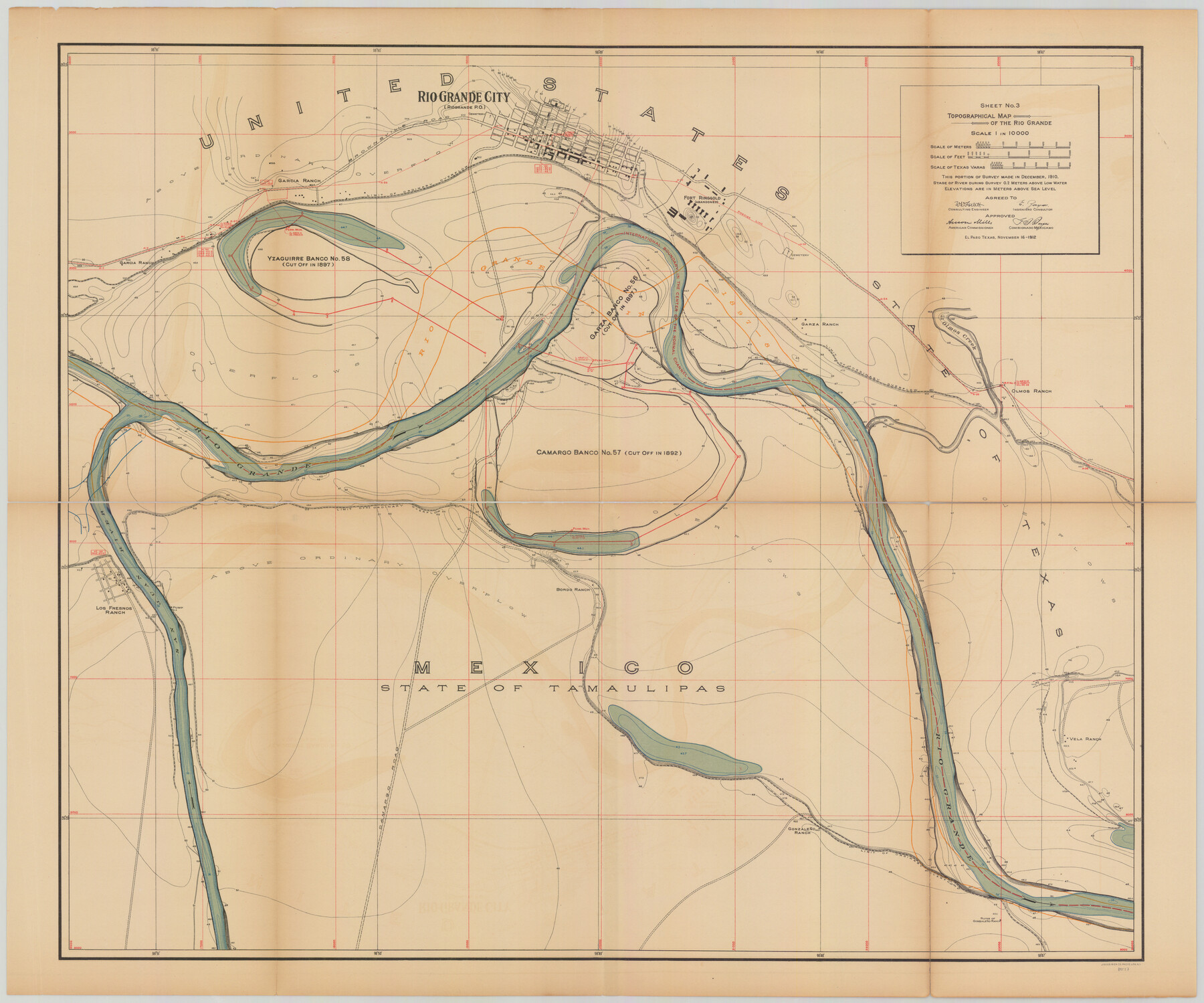
Topographical Map of the Rio Grande, Sheet No. 3
[from book: "Survey of the Rio Grande, Roma to the Gulf of Mexico, Reports and Maps"]
-
Map/Doc
89527
-
Collection
General Map Collection
-
Object Dates
1912/11/16 (Creation Date)
-
People and Organizations
International Boundary Commission (Publisher)
Anson Mills (Author)
E. Zayas (Surveyor/Engineer)
F.B. Puga (Author)
W.W. Follett (Surveyor/Engineer)
-
Subjects
River Surveys Texas Boundaries Topographic
-
Medium
paper
-
Scale
1:10000
-
Comments
This portion of the survey made in December 1910. State of river during survey 0.2 meters above low water. Elevations are in meters above sea level. This map and 31 others were originally folded and bound into a book titled "Survey of the Rio Grande,
Part of: General Map Collection
Flight Mission No. CGI-1N, Frame 133, Cameron County

Print $20.00
- Digital $50.00
Flight Mission No. CGI-1N, Frame 133, Cameron County
1955
Size 18.5 x 22.1 inches
Map/Doc 84489
Smith County Working Sketch 11

Print $20.00
- Digital $50.00
Smith County Working Sketch 11
1960
Size 18.6 x 21.6 inches
Map/Doc 63896
Controlled Mosaic by Jack Amman Photogrammetric Engineers, Inc - Sheet 16

Print $20.00
- Digital $50.00
Controlled Mosaic by Jack Amman Photogrammetric Engineers, Inc - Sheet 16
1954
Size 20.0 x 24.0 inches
Map/Doc 83460
Starr County Rolled Sketch 11

Print $20.00
- Digital $50.00
Starr County Rolled Sketch 11
1912
Size 16.5 x 16.4 inches
Map/Doc 7798
No. 3 Chart of Channel connecting Corpus Christi Bay with Aransas Bay, Texas

Print $20.00
- Digital $50.00
No. 3 Chart of Channel connecting Corpus Christi Bay with Aransas Bay, Texas
1878
Size 18.3 x 27.9 inches
Map/Doc 72779
Flight Mission No. CZW-2R, Frame 25, Hardeman County

Print $20.00
- Digital $50.00
Flight Mission No. CZW-2R, Frame 25, Hardeman County
1956
Size 18.7 x 22.4 inches
Map/Doc 85237
Travis County Sketch File 31

Print $4.00
- Digital $50.00
Travis County Sketch File 31
1889
Size 12.9 x 8.8 inches
Map/Doc 38345
Motley County Boundary File 2d

Print $22.00
- Digital $50.00
Motley County Boundary File 2d
Size 14.3 x 8.7 inches
Map/Doc 57550
Zavala County Boundary File 2

Print $36.00
- Digital $50.00
Zavala County Boundary File 2
Size 9.2 x 4.3 inches
Map/Doc 60239
[Map of the Houston and G. N. R.R. and lands adjacent, from Troupe to the Texas Pacific R.R.]
![64628, [Map of the Houston and G. N. R.R. and lands adjacent, from Troupe to the Texas Pacific R.R.], General Map Collection](https://historictexasmaps.com/wmedia_w700/maps/64628.tif.jpg)
Print $40.00
- Digital $50.00
[Map of the Houston and G. N. R.R. and lands adjacent, from Troupe to the Texas Pacific R.R.]
1873
Size 20.2 x 49.3 inches
Map/Doc 64628
Cooke County Sketch File 36

Print $4.00
- Digital $50.00
Cooke County Sketch File 36
1881
Size 7.8 x 8.4 inches
Map/Doc 19304
Flight Mission No. BRE-2P, Frame 125, Nueces County

Print $20.00
- Digital $50.00
Flight Mission No. BRE-2P, Frame 125, Nueces County
1956
Size 18.5 x 22.6 inches
Map/Doc 86801
You may also like
[Blocks 56 and 57, Townships 1 and 2]
![91315, [Blocks 56 and 57, Townships 1 and 2], Twichell Survey Records](https://historictexasmaps.com/wmedia_w700/maps/91315-1.tif.jpg)
Print $20.00
- Digital $50.00
[Blocks 56 and 57, Townships 1 and 2]
Size 19.3 x 20.5 inches
Map/Doc 91315

Topographic Map of Texas and Oklahoma Boundary, Fort Augur Area

Print $20.00
Topographic Map of Texas and Oklahoma Boundary, Fort Augur Area
1924
Size 17.2 x 33.7 inches
Map/Doc 79754
Industrial Site, Imperial State Prison Farm, Sugarland, Texas

Print $20.00
- Digital $50.00
Industrial Site, Imperial State Prison Farm, Sugarland, Texas
Size 26.6 x 27.5 inches
Map/Doc 73562
Water-Shed of the Pease River Drainage Area

Print $6.00
- Digital $50.00
Water-Shed of the Pease River Drainage Area
Size 14.9 x 31.0 inches
Map/Doc 65102
Jones County Sketch File 13

Print $20.00
- Digital $50.00
Jones County Sketch File 13
Size 43.5 x 35.7 inches
Map/Doc 10511
Erath County Working Sketch 37

Print $20.00
- Digital $50.00
Erath County Working Sketch 37
1973
Size 21.4 x 22.6 inches
Map/Doc 69118
Gregg County Rolled Sketch 16A

Print $20.00
- Digital $50.00
Gregg County Rolled Sketch 16A
1942
Size 30.1 x 40.4 inches
Map/Doc 6039
Amistad International Reservoir on Rio Grande 80

Print $20.00
- Digital $50.00
Amistad International Reservoir on Rio Grande 80
1949
Size 28.4 x 40.2 inches
Map/Doc 75509
Val Verde County Rolled Sketch 65

Print $20.00
- Digital $50.00
Val Verde County Rolled Sketch 65
1956
Size 43.0 x 45.0 inches
Map/Doc 10083
[River Secs. 68 1/2-73, Pt. Blk. GG]
![90478, [River Secs. 68 1/2-73, Pt. Blk. GG], Twichell Survey Records](https://historictexasmaps.com/wmedia_w700/maps/90478-1.tif.jpg)
Print $20.00
- Digital $50.00
[River Secs. 68 1/2-73, Pt. Blk. GG]
Size 27.6 x 20.7 inches
Map/Doc 90478
General Highway Map, Live Oak County, Texas

Print $20.00
General Highway Map, Live Oak County, Texas
1961
Size 18.3 x 24.8 inches
Map/Doc 79575