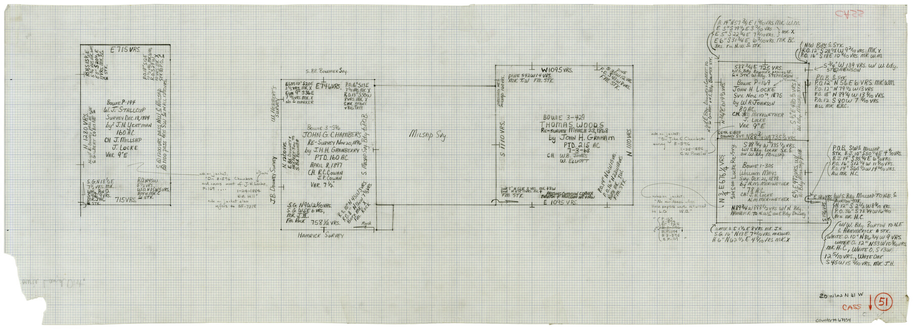
Cass County Working Sketch 51
-
Map/Doc
67954
-
Collection
General Map Collection
-
Counties
Cass
-
Subjects
Surveying Working Sketch
-
Height x Width
13.1 x 36.5 inches
33.3 x 92.7 cm
Part of: General Map Collection
Val Verde County Sketch File Z4

Print $8.00
- Digital $50.00
Val Verde County Sketch File Z4
1885
Size 14.3 x 8.9 inches
Map/Doc 39134
Sutton County Working Sketch 8

Print $20.00
- Digital $50.00
Sutton County Working Sketch 8
Size 14.2 x 21.6 inches
Map/Doc 62351
Webb County Working Sketch 92

Print $20.00
- Digital $50.00
Webb County Working Sketch 92
1988
Size 30.6 x 37.0 inches
Map/Doc 72459
Flight Mission No. BRA-16M, Frame 124, Jefferson County

Print $20.00
- Digital $50.00
Flight Mission No. BRA-16M, Frame 124, Jefferson County
1953
Size 18.7 x 22.5 inches
Map/Doc 85734
Harris County Rolled Sketch P58

Print $20.00
- Digital $50.00
Harris County Rolled Sketch P58
1929
Size 29.4 x 37.7 inches
Map/Doc 9119
Duval County Sketch File 81

Print $18.00
- Digital $50.00
Duval County Sketch File 81
Size 11.2 x 8.8 inches
Map/Doc 21507
Harris County Historic Topographic 25

Print $20.00
- Digital $50.00
Harris County Historic Topographic 25
1916
Size 29.2 x 22.7 inches
Map/Doc 65836
Dawson County Sketch File 20

Print $20.00
- Digital $50.00
Dawson County Sketch File 20
1951
Size 13.2 x 21.5 inches
Map/Doc 11296
Flight Mission No. DQN-1K, Frame 138, Calhoun County

Print $20.00
- Digital $50.00
Flight Mission No. DQN-1K, Frame 138, Calhoun County
1953
Size 18.6 x 22.3 inches
Map/Doc 84201
Polk County Sketch File 15

Print $8.00
- Digital $50.00
Polk County Sketch File 15
Size 12.7 x 8.4 inches
Map/Doc 34157
[Sketch showing the Rio Grande with towns and features annotated]
![72896, [Sketch showing the Rio Grande with towns and features annotated], General Map Collection](https://historictexasmaps.com/wmedia_w700/maps/72896.tif.jpg)
Print $20.00
- Digital $50.00
[Sketch showing the Rio Grande with towns and features annotated]
1854
Size 24.1 x 18.2 inches
Map/Doc 72896
Angelina County Working Sketch 25

Print $20.00
- Digital $50.00
Angelina County Working Sketch 25
1954
Size 25.0 x 17.5 inches
Map/Doc 67107
You may also like
Maverick County Working Sketch 23

Print $20.00
- Digital $50.00
Maverick County Working Sketch 23
1985
Size 37.8 x 36.4 inches
Map/Doc 70915
The Republic County of Milam. December 29, 1845

Print $20.00
The Republic County of Milam. December 29, 1845
2020
Size 17.4 x 21.6 inches
Map/Doc 96233
Map of Hill County

Print $40.00
- Digital $50.00
Map of Hill County
1884
Size 80.1 x 68.0 inches
Map/Doc 82049
Stonewall County Sketch File 30

Print $120.00
- Digital $50.00
Stonewall County Sketch File 30
1986
Size 24.5 x 35.3 inches
Map/Doc 12370
The Coastal and Border League Lines

Print $20.00
The Coastal and Border League Lines
2020
Size 20.2 x 21.6 inches
Map/Doc 95977
Outer Continental Shelf Leasing Maps (Louisiana Offshore Operations)

Print $20.00
- Digital $50.00
Outer Continental Shelf Leasing Maps (Louisiana Offshore Operations)
1954
Size 20.4 x 13.1 inches
Map/Doc 76098
Johnson County

Print $20.00
- Digital $50.00
Johnson County
1943
Size 43.3 x 40.2 inches
Map/Doc 95549
Duval County Rolled Sketch 37

Print $20.00
- Digital $50.00
Duval County Rolled Sketch 37
Size 27.1 x 17.9 inches
Map/Doc 5752
El Paso County Rolled Sketch 64

Print $246.00
- Digital $50.00
El Paso County Rolled Sketch 64
1993
Size 11.3 x 8.7 inches
Map/Doc 41531
Nueces County Sketch File 12

Print $4.00
- Digital $50.00
Nueces County Sketch File 12
1848
Size 9.8 x 8.7 inches
Map/Doc 32528
Potter County

Print $20.00
- Digital $50.00
Potter County
1960
Size 42.6 x 34.6 inches
Map/Doc 66985
Runnels County Rolled Sketch B

Print $20.00
- Digital $50.00
Runnels County Rolled Sketch B
1891
Size 17.4 x 19.3 inches
Map/Doc 7540