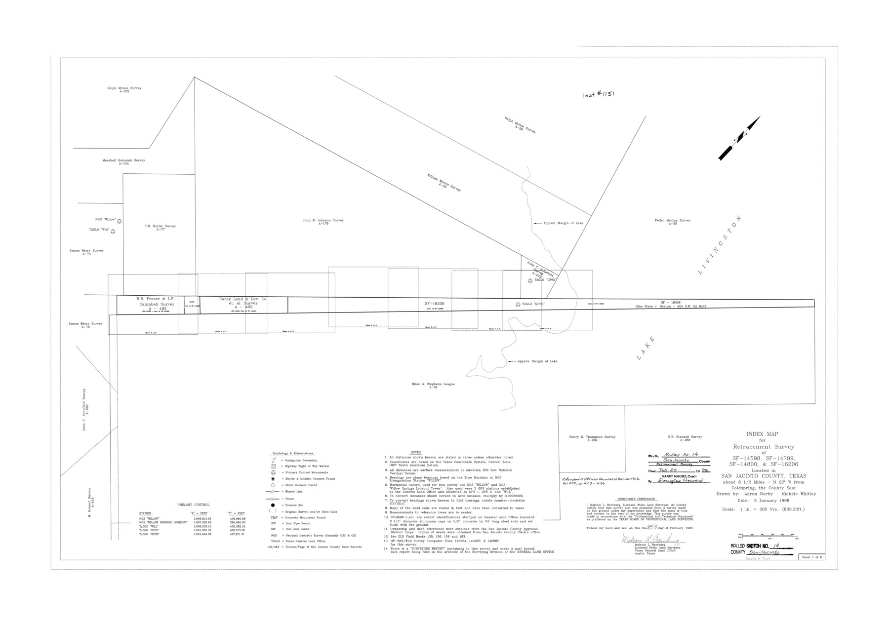
San Jacinto County Rolled Sketch 14
Index map for retracement survey of SF-14598, SF-14799, SF-14800, & SF-16206 located in San Jacinto County, Texas
-
Map/Doc
7563
-
Collection
General Map Collection
-
Object Dates
1998/2/25 (Creation Date)
1998/2/25 (File Date)
-
People and Organizations
Malcom L. Bamburg (Surveyor/Engineer)
Aaron Norby (Draftsman)
Michele Whitley (Draftsman)
-
Counties
San Jacinto
-
Subjects
Surveying Rolled Sketch
-
Height x Width
30.0 x 42.7 inches
76.2 x 108.5 cm
-
Medium
mylar, print
-
Scale
1" = 300 varas
Part of: General Map Collection
San Saba County Sketch File 6

Print $6.00
- Digital $50.00
San Saba County Sketch File 6
1881
Size 10.9 x 8.4 inches
Map/Doc 36414
Hudspeth County Rolled Sketch 36

Print $20.00
- Digital $50.00
Hudspeth County Rolled Sketch 36
1952
Size 30.8 x 19.9 inches
Map/Doc 6249
Atascosa County Rolled Sketch 27

Print $20.00
- Digital $50.00
Atascosa County Rolled Sketch 27
2012
Size 25.9 x 34.1 inches
Map/Doc 95410
Jeff Davis County Sketch File 36

Print $40.00
- Digital $50.00
Jeff Davis County Sketch File 36
1951
Size 17.1 x 14.3 inches
Map/Doc 28048
Chambers County Sketch File 37

Print $20.00
- Digital $50.00
Chambers County Sketch File 37
Size 25.0 x 43.8 inches
Map/Doc 10333
Webb County Boundary File 8

Print $113.00
- Digital $50.00
Webb County Boundary File 8
Size 14.3 x 8.8 inches
Map/Doc 59822
Cherokee County Sketch File 19

Print $4.00
- Digital $50.00
Cherokee County Sketch File 19
1876
Size 8.2 x 8.4 inches
Map/Doc 18161
San Jacinto River and Tributaries, Texas - Survey of 1939

Print $20.00
- Digital $50.00
San Jacinto River and Tributaries, Texas - Survey of 1939
1939
Size 28.0 x 40.3 inches
Map/Doc 60305
Bosque County Sketch File 8

Print $4.00
- Digital $50.00
Bosque County Sketch File 8
1858
Size 12.4 x 8.2 inches
Map/Doc 14752
Armstrong County Rolled Sketch B1

Print $20.00
- Digital $50.00
Armstrong County Rolled Sketch B1
1903
Size 25.8 x 37.8 inches
Map/Doc 5085

Lee County Working Sketch 19

Print $20.00
- Digital $50.00
Lee County Working Sketch 19
1991
Size 33.1 x 20.1 inches
Map/Doc 70398
You may also like
Flight Mission No. BRE-1P, Frame 72, Nueces County

Print $20.00
- Digital $50.00
Flight Mission No. BRE-1P, Frame 72, Nueces County
1956
Size 18.4 x 22.3 inches
Map/Doc 86654
Hill County Sketch File 6

Print $4.00
- Digital $50.00
Hill County Sketch File 6
1848
Size 13.9 x 8.7 inches
Map/Doc 26470
Tarrant County Working Sketch Graphic Index

Print $20.00
- Digital $50.00
Tarrant County Working Sketch Graphic Index
1942
Size 44.0 x 35.8 inches
Map/Doc 76708
Maps of Gulf Intracoastal Waterway, Texas - Sabine River to the Rio Grande and connecting waterways including ship channels

Print $20.00
- Digital $50.00
Maps of Gulf Intracoastal Waterway, Texas - Sabine River to the Rio Grande and connecting waterways including ship channels
1966
Size 14.6 x 20.7 inches
Map/Doc 61999
Atascosa County Sketch File 6

Print $26.00
- Digital $50.00
Atascosa County Sketch File 6
Size 12.2 x 7.8 inches
Map/Doc 13752
Dallas County Working Sketch 9

Print $20.00
- Digital $50.00
Dallas County Working Sketch 9
1960
Size 23.1 x 20.0 inches
Map/Doc 68575
Terrell County Rolled Sketch 14

Print $40.00
- Digital $50.00
Terrell County Rolled Sketch 14
Size 52.6 x 16.0 inches
Map/Doc 10309
[Galveston, Harrisburg & San Antonio Railroad from Cuero to Stockdale]
![64194, [Galveston, Harrisburg & San Antonio Railroad from Cuero to Stockdale], General Map Collection](https://historictexasmaps.com/wmedia_w700/maps/64194.tif.jpg)
Print $20.00
- Digital $50.00
[Galveston, Harrisburg & San Antonio Railroad from Cuero to Stockdale]
1907
Size 13.6 x 34.0 inches
Map/Doc 64194
Seminole, Gaines County, Texas

Print $20.00
- Digital $50.00
Seminole, Gaines County, Texas
Size 25.6 x 39.0 inches
Map/Doc 92692
Coke County Boundary File 2

Print $64.00
- Digital $50.00
Coke County Boundary File 2
Size 49.0 x 9.0 inches
Map/Doc 51580
Montgomery County Working Sketch 55

Print $20.00
- Digital $50.00
Montgomery County Working Sketch 55
1961
Size 23.8 x 34.6 inches
Map/Doc 71162
Lamb County Sketch File B

Print $6.00
- Digital $50.00
Lamb County Sketch File B
1902
Size 11.2 x 8.8 inches
Map/Doc 29344