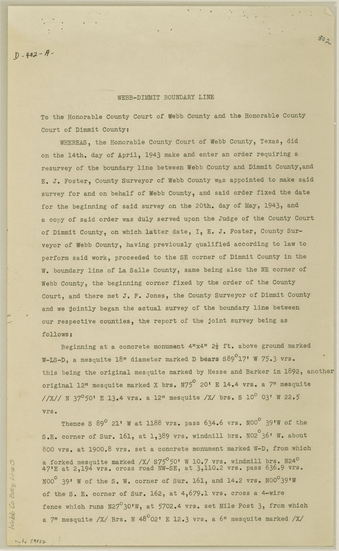
Webb County Boundary File 8
Webb-Dimmit Boundary Lines
-
Map/Doc
59822
-
Collection
General Map Collection
-
Counties
Webb
-
Subjects
County Boundaries
-
Height x Width
14.3 x 8.8 inches
36.3 x 22.4 cm
Part of: General Map Collection
Stieler Map of 1879

Print $4.00
- Digital $50.00
Stieler Map of 1879
1879
Size 28.9 x 23.0 inches
Map/Doc 76057
Smith County Sketch File 9

Print $6.00
- Digital $50.00
Smith County Sketch File 9
1848
Size 16.2 x 10.4 inches
Map/Doc 36763
Lynn County Sketch File 17

Print $20.00
- Digital $50.00
Lynn County Sketch File 17
Size 13.2 x 20.9 inches
Map/Doc 12020
Cameron County NRC Article 33.136 Sketch 1

Print $3.00
- Digital $50.00
Cameron County NRC Article 33.136 Sketch 1
2001
Size 11.3 x 17.4 inches
Map/Doc 61558
Right-of-Way and Track Map, Houston and Brazos Valley Ry. Co. operated by the Houston and Brazos Valley Ry. Co.

Print $40.00
- Digital $50.00
Right-of-Way and Track Map, Houston and Brazos Valley Ry. Co. operated by the Houston and Brazos Valley Ry. Co.
1918
Size 24.9 x 56.4 inches
Map/Doc 64602
Cameron County Rolled Sketch 20C

Print $20.00
- Digital $50.00
Cameron County Rolled Sketch 20C
Size 13.1 x 11.9 inches
Map/Doc 5475
Edwards County Working Sketch 136

Print $20.00
- Digital $50.00
Edwards County Working Sketch 136
1997
Size 18.4 x 25.4 inches
Map/Doc 69012
Flight Mission No. DAG-23K, Frame 61, Matagorda County

Print $20.00
- Digital $50.00
Flight Mission No. DAG-23K, Frame 61, Matagorda County
1953
Size 16.0 x 15.7 inches
Map/Doc 86488
Wharton County Boundary File 1

Print $24.00
- Digital $50.00
Wharton County Boundary File 1
Size 14.2 x 8.9 inches
Map/Doc 59839
Webb County Rolled Sketch 35

Print $20.00
- Digital $50.00
Webb County Rolled Sketch 35
1939
Size 23.1 x 12.7 inches
Map/Doc 8190
San Patricio County Rolled Sketch 20A

Print $20.00
- Digital $50.00
San Patricio County Rolled Sketch 20A
Size 25.9 x 30.3 inches
Map/Doc 7579
Blanco County Boundary File 6

Print $10.00
- Digital $50.00
Blanco County Boundary File 6
Size 8.5 x 9.6 inches
Map/Doc 50560
You may also like
J. O. Jones Land, Gaines County, Texas - Cedar Lake Meridian

Print $20.00
- Digital $50.00
J. O. Jones Land, Gaines County, Texas - Cedar Lake Meridian
Size 8.5 x 32.1 inches
Map/Doc 90792

PSL Field Notes for Block B13 in Crane, Ector, Ward, and Winkler Counties, Blocks B14 and B16 in Crane and Ector Counties, Blocks B7 and B8 in Ector and Winkler Counties and Block B15 in Ector County

PSL Field Notes for Block B13 in Crane, Ector, Ward, and Winkler Counties, Blocks B14 and B16 in Crane and Ector Counties, Blocks B7 and B8 in Ector and Winkler Counties and Block B15 in Ector County
Map/Doc 81651
Coleman County Sketch File 22

Print $10.00
- Digital $50.00
Coleman County Sketch File 22
1871
Size 8.4 x 7.9 inches
Map/Doc 18698
[Sketch showing Block M-20, Sections 9 through 46 and Block 22, Sections 1 through 12]
![91717, [Sketch showing Block M-20, Sections 9 through 46 and Block 22, Sections 1 through 12], Twichell Survey Records](https://historictexasmaps.com/wmedia_w700/maps/91717-1.tif.jpg)
Print $3.00
- Digital $50.00
[Sketch showing Block M-20, Sections 9 through 46 and Block 22, Sections 1 through 12]
Size 10.9 x 13.9 inches
Map/Doc 91717
Map of Liberty County Texas

Print $20.00
- Digital $50.00
Map of Liberty County Texas
1895
Size 29.7 x 29.4 inches
Map/Doc 3811
Presidio County Working Sketch 120

Print $20.00
- Digital $50.00
Presidio County Working Sketch 120
1984
Size 34.6 x 28.9 inches
Map/Doc 71797
Montgomery County Texas Historical Map

Montgomery County Texas Historical Map
Size 23.2 x 35.3 inches
Map/Doc 94404
Map showing surveys made on Mustang Island

Print $40.00
- Digital $50.00
Map showing surveys made on Mustang Island
1945
Size 54.7 x 21.0 inches
Map/Doc 2948
Working Sketch in Gray, Donley, and Carson Counties, Texas

Print $20.00
- Digital $50.00
Working Sketch in Gray, Donley, and Carson Counties, Texas
1909
Size 22.7 x 27.0 inches
Map/Doc 90779
Newton County Sketch File 18

Print $24.00
- Digital $50.00
Newton County Sketch File 18
1886
Size 12.1 x 8.3 inches
Map/Doc 32393
Map of Hays County, Texas

Print $20.00
- Digital $50.00
Map of Hays County, Texas
1880
Size 41.8 x 35.8 inches
Map/Doc 16848