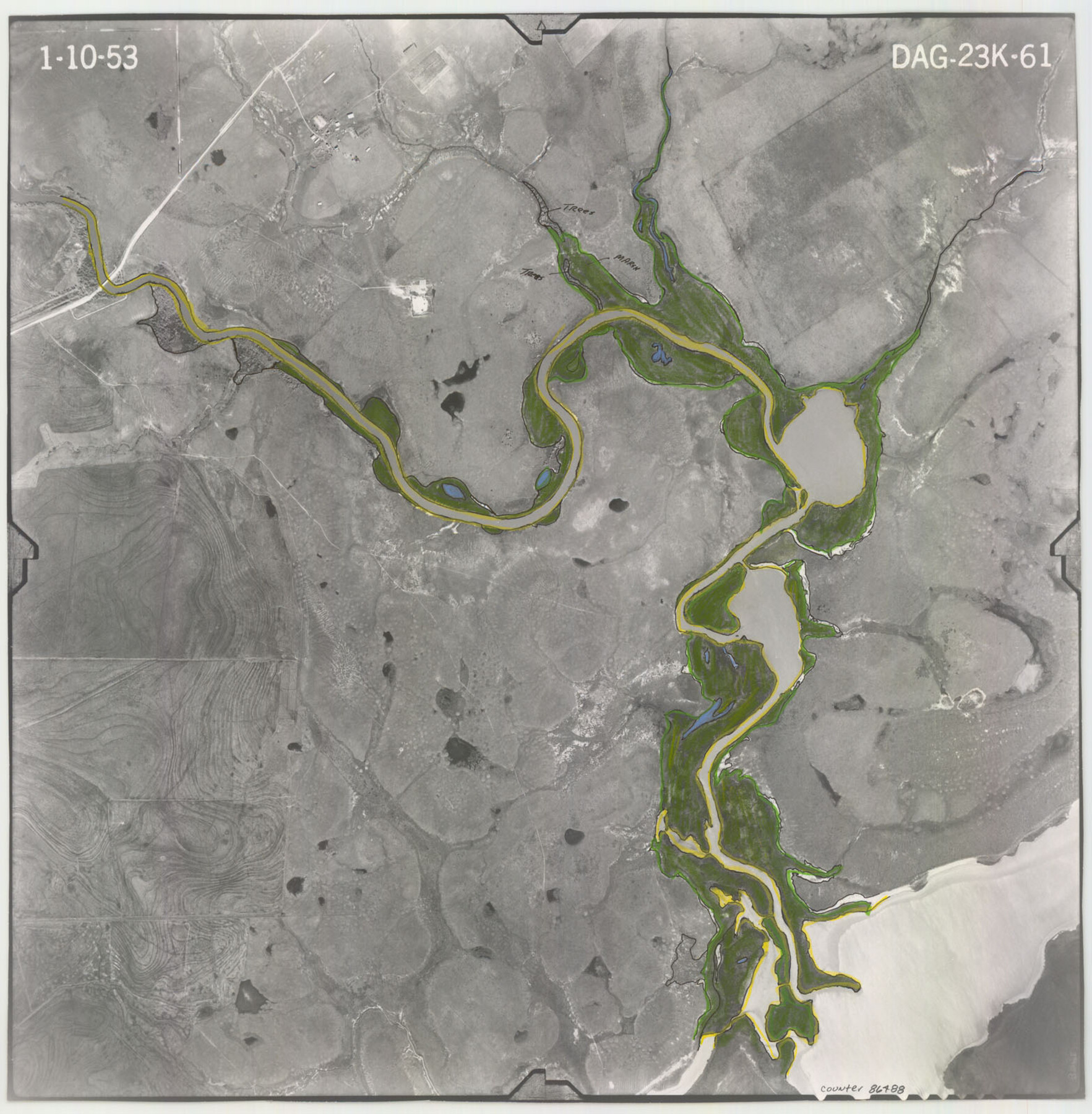
Flight Mission No. DAG-23K, Frame 61, Matagorda County
DAG-23K-61
-
Map/Doc
86488
-
Collection
General Map Collection
-
Object Dates
1953/1/10 (Creation Date)
-
People and Organizations
U. S. Department of Agriculture (Publisher)
-
Counties
Matagorda
-
Subjects
Aerial Photograph
-
Height x Width
16.0 x 15.7 inches
40.6 x 39.9 cm
-
Comments
Flown by Aero Exploration Company of Tulsa, Oklahoma.
Part of: General Map Collection
Galveston County NRC Article 33.136 Sketch 50

Print $24.00
- Digital $50.00
Galveston County NRC Article 33.136 Sketch 50
2008
Size 24.0 x 36.3 inches
Map/Doc 88750
Map of Wharton County

Print $20.00
- Digital $50.00
Map of Wharton County
1878
Size 22.4 x 29.9 inches
Map/Doc 4134
Chart of the West Indies and Spanish Dominions in North America

Print $40.00
- Digital $50.00
Chart of the West Indies and Spanish Dominions in North America
Size 49.1 x 75.6 inches
Map/Doc 97153
Runnels County Sketch File 13

Print $2.00
Runnels County Sketch File 13
Size 8.0 x 6.2 inches
Map/Doc 35456
Houston & Great Northern RR through Smith & other counties

Print $66.00
- Digital $50.00
Houston & Great Northern RR through Smith & other counties
1872
Size 14.2 x 8.4 inches
Map/Doc 64339
Starr County Rolled Sketch 19

Print $20.00
- Digital $50.00
Starr County Rolled Sketch 19
1920
Size 20.8 x 24.9 inches
Map/Doc 7803
Galveston County NRC Article 33.136 Sketch 33

Print $20.00
- Digital $50.00
Galveston County NRC Article 33.136 Sketch 33
2003
Size 42.5 x 30.9 inches
Map/Doc 83285
Cochran County Sketch File 6

Print $10.00
- Digital $50.00
Cochran County Sketch File 6
1938
Size 11.2 x 8.6 inches
Map/Doc 18545
Gillespie County Working Sketch 14

Print $20.00
- Digital $50.00
Gillespie County Working Sketch 14
2011
Size 36.6 x 36.6 inches
Map/Doc 90096
[Sketch for Mineral Application 24072, San Jacinto River]
![65591, [Sketch for Mineral Application 24072, San Jacinto River], General Map Collection](https://historictexasmaps.com/wmedia_w700/maps/65591.tif.jpg)
Print $20.00
- Digital $50.00
[Sketch for Mineral Application 24072, San Jacinto River]
1929
Size 21.0 x 39.8 inches
Map/Doc 65591
Wheeler County Sketch File 2

Print $26.00
- Digital $50.00
Wheeler County Sketch File 2
1881
Size 19.0 x 7.9 inches
Map/Doc 39994
Dimmit County Working Sketch 31

Print $20.00
- Digital $50.00
Dimmit County Working Sketch 31
1959
Size 26.3 x 42.8 inches
Map/Doc 68692
You may also like
Pecos County Working Sketch Graphic Index - northeast part - sheet B

Print $20.00
- Digital $50.00
Pecos County Working Sketch Graphic Index - northeast part - sheet B
1975
Size 36.0 x 42.2 inches
Map/Doc 76667

Map of the South West Railway System - Missouri Pacific Ry., Central Branch U.P. R.R., Missouri, Kansas & Texas Ry., Texas and Pacific Ry., St. Louis, Iron Mountn. and Southern Ry., International and Great Northern Ry., and their connections

Print $20.00
- Digital $50.00
Map of the South West Railway System - Missouri Pacific Ry., Central Branch U.P. R.R., Missouri, Kansas & Texas Ry., Texas and Pacific Ry., St. Louis, Iron Mountn. and Southern Ry., International and Great Northern Ry., and their connections
1883
Size 15.8 x 21.2 inches
Map/Doc 95788
Forester Cemetery

Print $20.00
- Digital $50.00
Forester Cemetery
1925
Size 23.0 x 28.8 inches
Map/Doc 92322
Tyler County Working Sketch 24

Print $20.00
- Digital $50.00
Tyler County Working Sketch 24
1989
Size 34.8 x 40.6 inches
Map/Doc 69494
Jackson County Working Sketch 11

Print $40.00
- Digital $50.00
Jackson County Working Sketch 11
1994
Size 33.8 x 48.4 inches
Map/Doc 66459
Flight Mission No. BQR-9K, Frame 12, Brazoria County

Print $20.00
- Digital $50.00
Flight Mission No. BQR-9K, Frame 12, Brazoria County
1952
Size 18.8 x 22.3 inches
Map/Doc 84041
Plat Showing Sections 11, 12, 19, and 20, Block A-9 Public School Land, Gaines County, Texas

Print $20.00
- Digital $50.00
Plat Showing Sections 11, 12, 19, and 20, Block A-9 Public School Land, Gaines County, Texas
1958
Size 18.2 x 21.8 inches
Map/Doc 92652
Bosque County Sketch File 26

Print $4.00
- Digital $50.00
Bosque County Sketch File 26
1868
Size 8.1 x 7.5 inches
Map/Doc 14811
Gray County Sketch File 8

Print $20.00
- Digital $50.00
Gray County Sketch File 8
1888
Size 17.7 x 20.7 inches
Map/Doc 11577
Stremme General Land Office Drawings, front view

Print $20.00
Stremme General Land Office Drawings, front view
Size 14.0 x 20.8 inches
Map/Doc 79738
